1970s Maps of Duval County, Texas
Explore 9 historic maps of Duval County from the 1970s. These maps offer a rare glimpse into what life looked like during the 1970s — showing old roads, neighborhoods, homes, and landmarks that have changed or disappeared over time.
Whether you're researching your family's past, planning a metal detecting trip, or studying how Duval County's landscape evolved across the 1970s, these high-resolution maps are a powerful tool for exploring the history of this region.
- Focus on a specific era: All maps on this page are from the 1970s, giving you a focused view of this time period.
- See what’s changed: Compare century-old streets, trails, and buildings to today's modern landscape using overlays and satellite layers.
- Research with precision: Use these maps for genealogy, historical research, land use analysis, or educational projects.
- View, download, or print: Maps are fully viewable online in high resolution, and can be downloaded or printed for your own records.
Start exploring Duval County's history through authentic maps from the 1970s. This is your window into the past.
Duval County, TX maps
(9)- 1971 Map of Freer North, 1974 Print
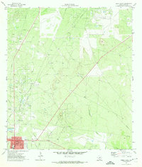 1971 Freer North1974 Print · USGSSouth Texas oil country comes into sharp focus during the early 1970s, as energy production transforms the Duval County landscape. Genealogists and historians can trace the development of Freer, locating the Hahl Memorial Cem and the vast industrial networks of the Seven Sisters Oil Field.
 - 1971 Map of Freer South, 1974 Print
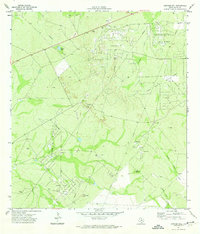
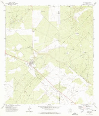
 1971 Freer South1974 Print · USGSOil production dominates the Duval County landscape in the early seventies, centered around the growing hub of Freer. Genealogists and historians can trace the local infrastructure of the Loma Novia Oil Field, find the High Sch, and locate the old Cem near Tarancahuas Creek.2 unique versions available
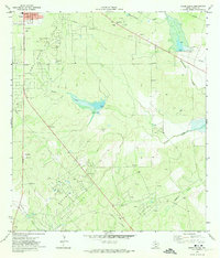
 - 1971 Map of Freer NW, 1974 Print
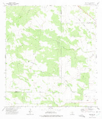
 1971 Freer NW1974 Print · USGSThe oil-rich plains of Duval County are captured here in the early 1970s as the regional energy economy expanded north of town. Researchers can trace the extensive network of the Government Wells Oil Field and historic ranch water features like Piedra Tank and Thomas Tank.
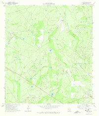
 - 1971 Map of Sarnosa Hill, 1974 Print
 1971 Sarnosa Hill1974 Print · USGSDuval County in the early seventies shows a landscape defined by the Texas energy boom, crisscrossed by pipelines and access roads. Researchers can trace the extensive operations at Government Wells Oil Field and locate local landmarks like Daval Ranch or the Landing Strip.
 - 1972 Map of Bruni SE, 1975 Print
 1972 Bruni SE1975 Print · USGSIn the early 1970s, this corner of South Texas was a hub for energy extraction where Webb, Duval, and Jim Hogg counties meet. Genealogists and historians can trace the Texas Mexican railroad line, locate the Greenhill Cem, and map the extent of the Yeager Oil Field.
 - 1972 Map of Bruni, 1975 Print
 1972 Bruni1975 Print · USGSWebb and Duval County ranchlands are captured here in the 1970s during a period of intense oil exploration. You can trace the Texas Mexican rail line through Bruni, find numerous oil derricks in the Cole Oil Field, and locate named landmarks like El Medio Windmill.
 - 1974 Map of Piedra Creek SE, 1977 Print
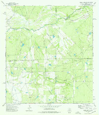 1974 Piedra Creek SE1977 Print · USGSThe South Texas brush country at the meeting of four counties is captured here in the mid-1970s. Researchers can trace family landmarks like the Adami Cem or map the energy footprint of the Rodriguez Oil Field and scattered Gas Wells.
 - 1974 Map of Biel Lake SE, 1977 Print
 1974 Biel Lake SE1977 Print · USGSPetroleum production and ranch land define the border of Webb and Duval counties during the mid-seventies. Researchers can trace energy infrastructure across the Lopez Oil Field, find scattered Oil Wells, and locate the Arroyo de Charco Escondido.
 - 1974 Map of Biel Lake NE, 1977 Print
 1974 Biel Lake NE1977 Print · USGSThe Webb and Duval county line in the mid-seventies was a center of intensive energy production. Researchers can trace the infrastructure of the Charamusca Oil Field, from the central refinery to scattered oil wells and pipelines.
End of results
Showing maps 1-9 of 9
Top cities of Duval County
Frequently asked questions
- What are the different types of historical maps available for Duval County?
- What is the oldest map of Duval County?
- Where can I purchase historical maps of Duval County for my home or office?
- Where can I download high-res historical maps of Duval County?
- Are there historical topographic maps available for Duval County?
- Is there historical aerial imagery available for Duval County?
- Where are historical maps of Duval County sourced from?