1950s Maps of Duval County, Texas
Explore 8 historic maps of Duval County from the 1950s. These maps offer a rare glimpse into what life looked like during the 1950s — showing old roads, neighborhoods, homes, and landmarks that have changed or disappeared over time.
Whether you're researching your family's past, planning a metal detecting trip, or studying how Duval County's landscape evolved across the 1950s, these high-resolution maps are a powerful tool for exploring the history of this region.
- Focus on a specific era: All maps on this page are from the 1950s, giving you a focused view of this time period.
- See what’s changed: Compare century-old streets, trails, and buildings to today's modern landscape using overlays and satellite layers.
- Research with precision: Use these maps for genealogy, historical research, land use analysis, or educational projects.
- View, download, or print: Maps are fully viewable online in high resolution, and can be downloaded or printed for your own records.
Start exploring Duval County's history through authentic maps from the 1950s. This is your window into the past.
Duval County, TX maps
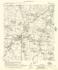
(8)- 1953 Map of Crystal City
 1953 Crystal City1953 Print · USGSSouth Texas in the early fifties was a landscape of expanding oil fields and vital rail connections. Genealogists and researchers can trace family lands along the Nueces River or locate heritage sites in Asherton, Big Wells, and Batesville.
 - 1955 Map of Crystal City, 1976 Print
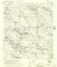
 1955 Crystal City1976 Print · USGSSouth Texas ranching and oil country come into focus in the mid-fifties as the rail lines and rivers connect growing hubs. Researchers can trace the development of energy fields like Washburn Oil Field or locate historic settlements from Asherton to Three Rivers.
 - 1956 Map of Benavides
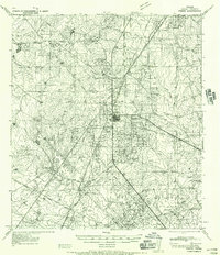
 1956 Benavides1956 Print · USGSCoastal plains ranching and the arrival of the oil industry define this South Texas landscape in the early twentieth century. Genealogists can trace family heritage through numerous named homesteads like Hoffman Ranch and Stein Ranch or the tracks of the Texas Mexican R. R.
 - 1956 Map of Rosita Ranch
 1956 Rosita Ranch1956 Print · USGSSouth Texas cattle country is shown here in the early twentieth century, revealing a landscape of family-owned ranching empires and rail connections. Genealogists and historians can trace lineage and land use through labels like Rosita Ranch, the Mendieto post office, and the path of the T. M. R. R.
 - 1956 Map of Freer
 1956 Freer1956 Print · USGSDuval County is shown during a period of intense oil development and traditional ranching in the mid-1950s. Genealogists and historians can trace family properties like Cuatitas Ranch and R Mendez alongside prolific energy sites like Seven Sisters Field.
 - 1956 Map of Piedra Creek
 1956 Piedra Creek1956 Print · USGSThe ranching country of La Salle and McMullen Counties is captured here in the mid-1950s, following military surveys of the brushy plains. Researchers can locate remote family landmarks like the Dobie Ranch or trace the early Oil Field at Munson.
 - 1956 Map of Las Mujeres
 1956 Las Mujeres1956 Print · USGSRanching life on the Webb and Duval county border is captured here during the mid-twentieth century as new infrastructure began to arrive. Genealogists and historians can trace family land holdings such as Jotana Ranch, Puertacita Ranch, and the homestead of Don Adami.
 - 1956 Map of Laredo, 1960 Print
 1956 Laredo1960 Print · USGSSouth Texas in the mid-fifties reveals a landscape shaped by border commerce, military aviation, and a booming oil industry. Trace the historic Texas and Mexican RR line through Hebbronville or locate the sprawling Mirando City Oil Field and Laredo AFB.3 unique versions available
End of results
Showing maps 1-8 of 8
Top cities of Duval County
Frequently asked questions
- What are the different types of historical maps available for Duval County?
- What is the oldest map of Duval County?
- Where can I purchase historical maps of Duval County for my home or office?
- Where can I download high-res historical maps of Duval County?
- Are there historical topographic maps available for Duval County?
- Is there historical aerial imagery available for Duval County?
- Where are historical maps of Duval County sourced from?