1940s Maps of Socorro, Texas
Explore 4 historic maps of Socorro from the 1940s. These maps offer a rare glimpse into what life looked like during the 1940s — showing old roads, neighborhoods, homes, and landmarks that have changed or disappeared over time.
Whether you're researching your family's past, planning a metal detecting trip, or studying how Socorro's landscape evolved across the 1940s, these high-resolution maps are a powerful tool for exploring the history of this region.
- Focus on a specific era: All maps on this page are from the 1940s, giving you a focused view of this time period.
- See what’s changed: Compare century-old streets, trails, and buildings to today's modern landscape using overlays and satellite layers.
- Research with precision: Use these maps for genealogy, historical research, land use analysis, or educational projects.
- View, download, or print: Maps are fully viewable online in high resolution, and can be downloaded or printed for your own records.
Start exploring Socorro's history through authentic maps from the 1940s. This is your window into the past.
Socorro, TX maps
(4)- 1941 Map of Clint
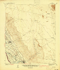 1941 Clint1941 Print · USGSThe Rio Grande valley southeast of El Paso comes alive in the early 1940s, showing a landscape defined by irrigation and iron rails. Researchers can trace the development of Clint, Fabens, and Cuadrilla along the Texas and Pacific railroad.
 - 1941 Map of Ysleta
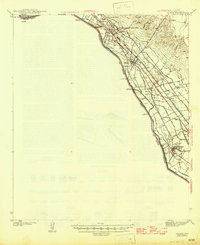
 1941 Ysleta1941 Print · USGSThe El Paso Lower Valley was a thriving corridor of irrigation and international trade just before the war. Researchers can trace the heritage of the Rio Grande through the San Antonio Mission, the Ysleta Jesuit College, and the grounds of the County Farm.
 - 1945 Map of Ysleta
 1945 Ysleta1945 Print · USGSThe Rio Grande valley southeast of El Paso comes alive in the mid-forties, showing the vital irrigation networks and rail lines that sustained the border. Genealogists and historians can trace family roots near San Antonio Mission, Ysleta, and the CCC Camp.
 - 1945 Map of Clint
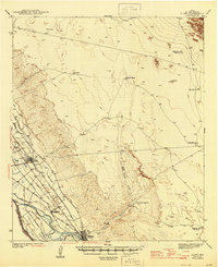 1945 Clint1945 Print · USGSThe irrigated valley of the Rio Grande near El Paso comes alive in this mid-century survey of the West Texas borderlands. Genealogists and historians can trace the rail lines through Clint and Fabens or locate remote outposts like Roberts Ranch and the San Felipe Ranch.
End of results
Showing maps 1-4 of 4
Top cities near Socorro
- El Paso historical maps
- Horizon City historical maps
- San Elizario historical maps
- Fabens historical maps
- Tornillo historical maps
- Clint historical maps
Top neighborhoods of Socorro
- El Campestre Colonia historical maps
- El Gran Valle Colonia historical maps
- El Gran Valle Number 2 Colonia historical maps
- Angie Colonia historical maps
- Lewis Colonia historical maps
- Friedman Estates Number 1 Colonia historical maps
See more
Frequently asked questions
- What are the different types of historical maps available for Socorro?
- What is the oldest map of Socorro?
- Where can I purchase historical maps of Socorro for my home or office?
- Where can I download high-res historical maps of Socorro?
- Are there historical topographic maps available for Socorro?
- Is there historical aerial imagery available for Socorro?
- Where are historical maps of Socorro sourced from?