1990s Maps of Socorro, Texas
Explore 3 historic maps of Socorro from the 1990s. These maps offer a rare glimpse into what life looked like during the 1990s — showing old roads, neighborhoods, homes, and landmarks that have changed or disappeared over time.
Whether you're researching your family's past, planning a metal detecting trip, or studying how Socorro's landscape evolved across the 1990s, these high-resolution maps are a powerful tool for exploring the history of this region.
- Focus on a specific era: All maps on this page are from the 1990s, giving you a focused view of this time period.
- See what’s changed: Compare century-old streets, trails, and buildings to today's modern landscape using overlays and satellite layers.
- Research with precision: Use these maps for genealogy, historical research, land use analysis, or educational projects.
- View, download, or print: Maps are fully viewable online in high resolution, and can be downloaded or printed for your own records.
Start exploring Socorro's history through authentic maps from the 1990s. This is your window into the past.
Socorro, TX maps
(3)- 1994 Map of Ysleta
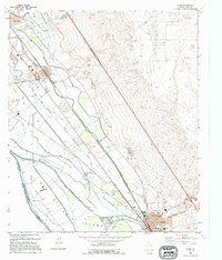
 1994 Ysleta1994 Print · USGSEl Paso's lower valley comes into focus during the early nineties, showing the historic corridor between the river and the desert mesa. Researchers can trace the heritage of the Ysleta Mission, locate La Purisima Cem, and see the layout of Socorro.
 - 1995 Map of Clint NW
 1995 Clint NW1995 Print · USGSEl Paso County's desert periphery underwent significant transformation during the mid-nineties as residential communities like Horizon City expanded. Researchers can trace local infrastructure and landmarks such as West Texas Airport, Desert Hills Sch, and the Ysleta Lateral.
 - 1995 Map of Clint
 1995 Clint1995 Print · USGSEl Paso County's river valley during the mid-nineties shows a landscape shaped by the Rio Grande and its extensive irrigation canals. Genealogists can trace family footprints at San Lorenzo Cemetery or explore the grids of Clint, Fabens, and Cuadrilla.
End of results
Showing maps 1-3 of 3
Top cities near Socorro
- El Paso historical maps
- Horizon City historical maps
- San Elizario historical maps
- Fabens historical maps
- Tornillo historical maps
- Clint historical maps
Top neighborhoods of Socorro
- Aljo Estates Colonia historical maps
- Mesa Verde Colonia historical maps
- Bejar Estates Colonia historical maps
- Cotton Valley Estates Colonia historical maps
- La Fuente Colonia historical maps
- Rancho Miraval Estates Colonia historical maps
See more
Frequently asked questions
- What are the different types of historical maps available for Socorro?
- What is the oldest map of Socorro?
- Where can I purchase historical maps of Socorro for my home or office?
- Where can I download high-res historical maps of Socorro?
- Are there historical topographic maps available for Socorro?
- Is there historical aerial imagery available for Socorro?
- Where are historical maps of Socorro sourced from?