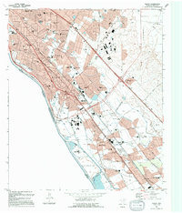
1994 Map of Ysleta
USGS Topo · Published 1994About this map
The Rio Grande defines the international boundary in this detailed look at the lower Valley of El Paso during the early 1990s. The landscape is a dense mixture of residential growth and ancient settlement patterns, most notably around the Ysleta Mission and Socorro. While modern infrastructure like the Zaragosa Port of Entry and the Americas Ave corridor highlight the area's role as a major border crossing, the presence of the Socorro Mission and La Purisima Cem speaks to centuries of cultural history. A complex network of irrigation features, including the Riverside Canal and Playa Lateral, reflects the valley's agricultural roots even as neighborhoods like Hacienda Heights and Loma Terrace expand across the terrain. Public spaces such as Rio Bosque Park and dozens of local schools provide a look at the community's mid-century and modern social footprint.
Find a feature on this map
70 named features on this map. Tap any name to fly to it.
Don’t see what you’re looking for? This feature index may not catch every label — zoom into the map to look around manually.
Map Details
Editions of this 1994 Ysleta Map
This is the sole edition of this map. No revisions or reprints were ever made.
Other maps of this area

1896 · El Paso
USGS Topo · 1:125,000

1908 · El Paso
USGS Topo · 1:125,000

1939 · Ysleta
USGS Topo · 1:62,500

1939 · Heuco Tanks
USGS Topo · 1:62,500

1940 · Heuco Tanks
USGS Topo · 1:62,500

1941 · El Paso
USGS Topo · 1:31,680

1941 · Clint
USGS Topo · 1:62,500

1941 · Ysleta
USGS Topo · 1:62,500

1942 · Fort Bliss
USGS Topo · 1:62,500

1943 · El Paso
USGS Topo · 1:31,680