1960s Maps of Stephenville, Texas
Explore 2 historic maps of Stephenville from the 1960s. These maps offer a rare glimpse into what life looked like during the 1960s — showing old roads, neighborhoods, homes, and landmarks that have changed or disappeared over time.
Whether you're researching your family's past, planning a metal detecting trip, or studying how Stephenville's landscape evolved across the 1960s, these high-resolution maps are a powerful tool for exploring the history of this region.
- Focus on a specific era: All maps on this page are from the 1960s, giving you a focused view of this time period.
- See what’s changed: Compare century-old streets, trails, and buildings to today's modern landscape using overlays and satellite layers.
- Research with precision: Use these maps for genealogy, historical research, land use analysis, or educational projects.
- View, download, or print: Maps are fully viewable online in high resolution, and can be downloaded or printed for your own records.
Start exploring Stephenville's history through authentic maps from the 1960s. This is your window into the past.
Stephenville, TX maps
(2)- 1961 Map of Stephenville, 1963 Print
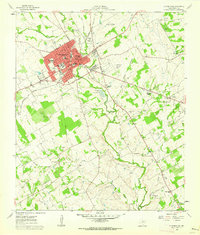 1961 Stephenville1963 Print · USGSStephenville and the surrounding Erath County countryside are documented here during a period of mid-century expansion. Genealogists and local historians can trace legacy sites from Tarleton State College to rural landmarks like Johnson Cemetery and Provident Church.4 unique versions available
 - 1965 Map of Bunyan, 1967 Print
 1965 Bunyan1967 Print · USGSErath County agriculture and water management are at the forefront during the mid-sixties as the region modernized its rural infrastructure. Researchers can trace family history through sites like Corinth Ch, Lone Oak Ch, and the Lower Green Creek Cem while mapping the path of the Atchison Topeka and Santa Fe railroad.
End of results
Showing maps 1-2 of 2
Top cities near Stephenville
Frequently asked questions
- What are the different types of historical maps available for Stephenville?
- What is the oldest map of Stephenville?
- Where can I purchase historical maps of Stephenville for my home or office?
- Where can I download high-res historical maps of Stephenville?
- Are there historical topographic maps available for Stephenville?
- Is there historical aerial imagery available for Stephenville?
- Where are historical maps of Stephenville sourced from?