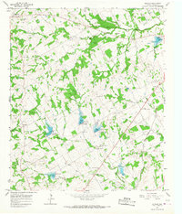
1965 Map of Bunyan
USGS Topo · Published 1967About this map
The South Fork Bosque River and North Bosque River converge in this mid-1960s snapshot of central Erath County, where the landscape is defined by a series of flood control structures and agricultural development. Small rural communities like Lingleville and Bunyan anchor the territory, connected by a network of ranch roads and the Atchison Topeka and Santa Fe railroad line cutting through the southeast.
Find a feature on this map
33 named features on this map. Tap any name to fly to it.
Don’t see what you’re looking for? This feature index may not catch every label — zoom into the map to look around manually.
Map Details
Editions of this 1965 Bunyan Map
This is the sole edition of this map. No revisions or reprints were ever made.
Other maps of this area

1890 · Stephenville
USGS Topo · 1:125,000

1920 · Stephenville
USGS Topo · 1:125,000

1954 · Abilene
USGS Topo · 1:250,000

1958 · Abilene
USGS Topo · 1:250,000
1961 · Alexander
USGS Topo · 1:24,000

1961 · Knob Hill
USGS Topo · 1:24,000

1961 · Stephenville
USGS Topo · 1:24,000

1965 · Huckabay SW
USGS Topo · 1:24,000

1965 · Lingleville
USGS Topo · 1:24,000
1965 · Dublin
USGS Topo · 1:24,000