1970s Maps of Fort Bend County, Texas
Explore 11 historic maps of Fort Bend County from the 1970s. These maps offer a rare glimpse into what life looked like during the 1970s — showing old roads, neighborhoods, homes, and landmarks that have changed or disappeared over time.
Whether you're researching your family's past, planning a metal detecting trip, or studying how Fort Bend County's landscape evolved across the 1970s, these high-resolution maps are a powerful tool for exploring the history of this region.
- Focus on a specific era: All maps on this page are from the 1970s, giving you a focused view of this time period.
- See what’s changed: Compare century-old streets, trails, and buildings to today's modern landscape using overlays and satellite layers.
- Research with precision: Use these maps for genealogy, historical research, land use analysis, or educational projects.
- View, download, or print: Maps are fully viewable online in high resolution, and can be downloaded or printed for your own records.
Start exploring Fort Bend County's history through authentic maps from the 1970s. This is your window into the past.
Fort Bend County, TX maps
(11)- 1970 Map of Alief, 1973 Print
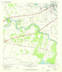
 1970 Alief1973 Print · USGSSouthwest Houston was undergoing rapid suburbanization in the early seventies as new developments bridged the gap between old railroad towns. Trace family history at Riceville Cemetery or locate landmarks like Andrau Airpark and Sharpstown Country Club.
 - 1970 Map of Clodine, 1973 Print
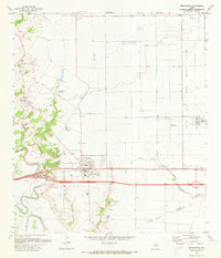
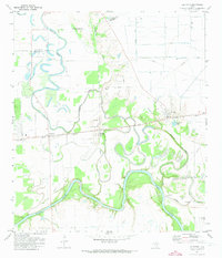
 1970 Clodine1973 Print · USGSFort Bend County in the early seventies shows a landscape of institutional farms and early suburban edges. Genealogists and researchers can trace the roads around Clodine, the grounds of the State Prison Farm, and local landmarks like Hull Field.
 - 1970 Map of Sugar Land, 1973 Print
 1970 Sugar Land1973 Print · USGSFort Bend County reveals its transition from rural prison farming to suburban expansion in the early seventies. Genealogists and researchers can trace family landmarks like Thompson Chapel, Sandberry Cem, and old rail stops at Crabb and Booth.3 unique versions available
 - 1970 Map of Missouri City, 1973 Print
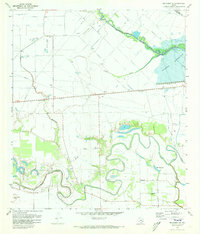
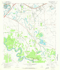 1970 Missouri City1973 Print · USGSFort Bend County's river-bottom lands were transitioning toward suburban growth in the late sixties as the boundaries of Sugar Land and Missouri City expanded. Researchers can trace historic local sites like Dewalt Cem, Trammels, and the John Foster Dulles High Sch.3 unique versions available
 - 1971 Map of Brookshire, 1973 Print
 1971 Brookshire1973 Print · USGSThe towns of Brookshire and Pattison are shown here in the early seventies, caught between traditional rice farming and the expanding oil industry. Researchers can trace family sites like Wilpitz Cemetery or follow the Missouri Kansas Texas rail line through Cardiff.2 unique versions available
 - 1971 Map of Orchard, 1973 Print
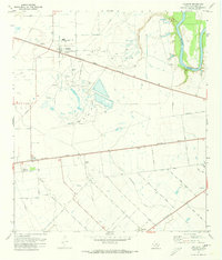 1971 Orchard1973 Print · USGSFort Bend County in the early 1970s shows a landscape defined by the Brazos River and a booming petroleum economy. You can trace industrial roots at the Orchard Dome Oil and Gas Field or locate local landmarks like the Cotton Gin in Tavener.3 unique versions available
 - 1971 Map of Fulshear, 1973 Print
 1971 Fulshear1973 Print · USGSFulshear and Simonton appear in the early 1970s as the Southern Pacific railroad and the winding Brazos River shape the local landscape. Researchers can locate several community landmarks including Jerusalem Starlight Ch, Zion Chapel, and the Huntington Mound.2 unique versions available
 - 1971 Map of Richmond, 1973 Print
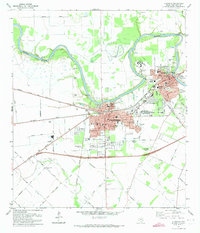 1971 Richmond1973 Print · USGSRichmond and Rosenberg appear during a period of steady growth along the Brazos River in the early seventies. Researchers can trace numerous burial sites and landmarks like Morton Cem, Richmond State Sch, and the Southern Pacific rail lines.2 unique versions available
 - 1971 Map of Richmond NE, 1973 Print
 1971 Richmond NE1973 Print · USGSFort Bend and Harris counties are captured in the early seventies, showcasing a rural landscape defined by creek meanders and early energy development. Genealogists can locate Goss Cem and Briscoe Cem or trace family sites near Foster and Gaston.3 unique versions available
 - 1971 Map of Katy, 1974 Print
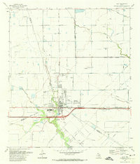 1971 Katy1974 Print · USGSThe town of Katy and its surrounding oil fields are documented here in the early 1970s, showing a prairie landscape transitioning into an industrial and suburban hub. Genealogists and local historians can locate Magnolia Cem, Beckendorf, and the Odessa Kilpatrick Sch along the Missouri Kansas Texas rail line.3 unique versions available
 - 1975 Map of Houston, 1977 Print
 1975 Houston1977 Print · USGSThe Texas Gulf Coast in the mid-seventies shows a sprawling Houston metropolis linked to the sea by the massive Houston Ship Channel. Researchers can trace the mid-century industrial landscape from the Astrodome to the Lyndon B. Johnson Space Center.2 unique versions available
End of results
Showing maps 1-11 of 11
Top cities of Fort Bend County
- Sugar Land historical maps
- Missouri City historical maps
- Rosenberg historical maps
- Fresno historical maps
- Stafford historical maps
- Richmond historical maps
See more
Frequently asked questions
- What are the different types of historical maps available for Fort Bend County?
- What is the oldest map of Fort Bend County?
- Where can I purchase historical maps of Fort Bend County for my home or office?
- Where can I download high-res historical maps of Fort Bend County?
- Are there historical topographic maps available for Fort Bend County?
- Is there historical aerial imagery available for Fort Bend County?
- Where are historical maps of Fort Bend County sourced from?