1990s Maps of Fort Bend County, Texas
Explore 7 historic maps of Fort Bend County from the 1990s. These maps offer a rare glimpse into what life looked like during the 1990s — showing old roads, neighborhoods, homes, and landmarks that have changed or disappeared over time.
Whether you're researching your family's past, planning a metal detecting trip, or studying how Fort Bend County's landscape evolved across the 1990s, these high-resolution maps are a powerful tool for exploring the history of this region.
- Focus on a specific era: All maps on this page are from the 1990s, giving you a focused view of this time period.
- See what’s changed: Compare century-old streets, trails, and buildings to today's modern landscape using overlays and satellite layers.
- Research with precision: Use these maps for genealogy, historical research, land use analysis, or educational projects.
- View, download, or print: Maps are fully viewable online in high resolution, and can be downloaded or printed for your own records.
Start exploring Fort Bend County's history through authentic maps from the 1990s. This is your window into the past.
Fort Bend County, TX maps
(7)- 1992 Map of Houston
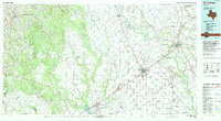
 1992 Houston1992 Print · USGSThe Houston metropolitan area reached its modern sprawl in the early nineties, centered on the Buffalo Bayou and a massive regional rail network. Genealogists and historians can trace the development of satellite cities like Sugar Land and Pasadena, or locate legacy sites like the Humble Oil Field and the NASA Lyndon B Johnson Space Center.
 - 1994 Map of El Campo
 1994 El Campo1994 Print · USGSCoastal Texas in the mid-nineties shows a landscape deeply shaped by the energy industry and rail logistics. Researchers can trace the sprawling Sheridan Gas Field or locate historic rail stops in El Campo, Spanish Camp, and Provident City.
 - 1995 Map of Alief, 1998 Print
 1995 Alief1998 Print · USGSWestern Houston and the Alief area are seen here during the rapid suburban growth of the mid-nineties. Genealogists and historians can trace local landmarks like Andrau Airpark, the Alief Brethren Cem, and the path of the Missouri Pacific railroad.
 - 1995 Map of Missouri City, 1999 Print
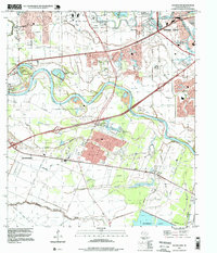
 1995 Missouri City1999 Print · USGSThe Houston suburbs were in the midst of a significant growth phase in the late nineties as residential tracts pushed into the Brazos River bottomlands. Researchers can find old family cemeteries and country churches like Dewalt Cem and St John Ch alongside the rails of the Missouri Pacific.
 - 1995 Map of Sugar Land, 1999 Print
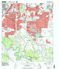
 1995 Sugar Land1999 Print · USGSFort Bend County in the mid-1990s shows a unique landscape where suburban growth meets large-scale institutional land use. Researchers can trace historic local sites like Crabb, the Sandberry Cem, and the sprawling Jester State Prison Farm.
 - 1995 Map of Almeda, 1999 Print
 1995 Almeda1999 Print · USGSThe southern outskirts of Houston and the Fort Bend prairie are shown here during a decade of rapid suburban growth. Genealogists and historians can trace old community landmarks like the Beth Jacob Cem, Mt Corinth Ch, and the rail junction at Arcola.
 - 1995 Map of Clodine, 1999 Print
 1995 Clodine1999 Print · USGSFort Bend and Harris counties were undergoing rapid suburban change in the mid-nineties as residential developments moved west toward the reservoir. Genealogists can locate family landmarks like Magee Cemetery and Hodges Bend Cem or trace the early footprint of Mission Bend.
End of results
Showing maps 1-7 of 7
Top cities of Fort Bend County
- Sugar Land historical maps
- Missouri City historical maps
- Rosenberg historical maps
- Fresno historical maps
- Stafford historical maps
- Richmond historical maps
See more
Frequently asked questions
- What are the different types of historical maps available for Fort Bend County?
- What is the oldest map of Fort Bend County?
- Where can I purchase historical maps of Fort Bend County for my home or office?
- Where can I download high-res historical maps of Fort Bend County?
- Are there historical topographic maps available for Fort Bend County?
- Is there historical aerial imagery available for Fort Bend County?
- Where are historical maps of Fort Bend County sourced from?