1970s Maps of Rosenberg, Texas
Explore 4 historic maps of Rosenberg from the 1970s. These maps offer a rare glimpse into what life looked like during the 1970s — showing old roads, neighborhoods, homes, and landmarks that have changed or disappeared over time.
Whether you're researching your family's past, planning a metal detecting trip, or studying how Rosenberg's landscape evolved across the 1970s, these high-resolution maps are a powerful tool for exploring the history of this region.
- Focus on a specific era: All maps on this page are from the 1970s, giving you a focused view of this time period.
- See what’s changed: Compare century-old streets, trails, and buildings to today's modern landscape using overlays and satellite layers.
- Research with precision: Use these maps for genealogy, historical research, land use analysis, or educational projects.
- View, download, or print: Maps are fully viewable online in high resolution, and can be downloaded or printed for your own records.
Start exploring Rosenberg's history through authentic maps from the 1970s. This is your window into the past.
Rosenberg, TX maps
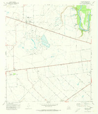
(4)- 1970 Map of Sugar Land, 1973 Print
 1970 Sugar Land1973 Print · USGSFort Bend County reveals its transition from rural prison farming to suburban expansion in the early seventies. Genealogists and researchers can trace family landmarks like Thompson Chapel, Sandberry Cem, and old rail stops at Crabb and Booth.3 unique versions available
 - 1971 Map of Orchard, 1973 Print
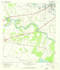
 1971 Orchard1973 Print · USGSFort Bend County in the early 1970s shows a landscape defined by the Brazos River and a booming petroleum economy. You can trace industrial roots at the Orchard Dome Oil and Gas Field or locate local landmarks like the Cotton Gin in Tavener.3 unique versions available
 - 1971 Map of Richmond, 1973 Print
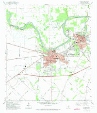 1971 Richmond1973 Print · USGSRichmond and Rosenberg appear during a period of steady growth along the Brazos River in the early seventies. Researchers can trace numerous burial sites and landmarks like Morton Cem, Richmond State Sch, and the Southern Pacific rail lines.2 unique versions available
 - 1975 Map of Houston, 1977 Print
 1975 Houston1977 Print · USGSThe Texas Gulf Coast in the mid-seventies shows a sprawling Houston metropolis linked to the sea by the massive Houston Ship Channel. Researchers can trace the mid-century industrial landscape from the Astrodome to the Lyndon B. Johnson Space Center.2 unique versions available
End of results
Showing maps 1-4 of 4
Top cities near Rosenberg
- Houston historical maps
- Sugar Land historical maps
- Katy historical maps
- Richmond historical maps
- Brookshire historical maps
- Needville historical maps
See more
Top neighborhoods of Rosenberg
Frequently asked questions
- What are the different types of historical maps available for Rosenberg?
- What is the oldest map of Rosenberg?
- Where can I purchase historical maps of Rosenberg for my home or office?
- Where can I download high-res historical maps of Rosenberg?
- Are there historical topographic maps available for Rosenberg?
- Is there historical aerial imagery available for Rosenberg?
- Where are historical maps of Rosenberg sourced from?