1910s Maps of Sugar Land, Texas
Explore 3 historic maps of Sugar Land from the 1910s. These maps offer a rare glimpse into what life looked like during the 1910s — showing old roads, neighborhoods, homes, and landmarks that have changed or disappeared over time.
Whether you're researching your family's past, planning a metal detecting trip, or studying how Sugar Land's landscape evolved across the 1910s, these high-resolution maps are a powerful tool for exploring the history of this region.
- Focus on a specific era: All maps on this page are from the 1910s, giving you a focused view of this time period.
- See what’s changed: Compare century-old streets, trails, and buildings to today's modern landscape using overlays and satellite layers.
- Research with precision: Use these maps for genealogy, historical research, land use analysis, or educational projects.
- View, download, or print: Maps are fully viewable online in high resolution, and can be downloaded or printed for your own records.
Start exploring Sugar Land's history through authentic maps from the 1910s. This is your window into the past.
Sugar Land, TX maps
(3)- 1915 Map of Alief
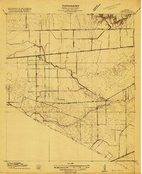 1915 Alief1915 Print · USGSIn the years before Houston's westward sprawl, this prairie landscape was a remote network of dairy farms and rail lines. You can trace the early foundations of these communities at Alief, Traceyville Church, and along the rural paths of Westheimer Road.3 unique versions available
 - 1915 Map of Clodine, 1961 Print
 1915 Clodine1961 Print · USGSSoutheast Texas prairie life is captured here during the mid-teens, when rail lines dictated the growth of small settlements. Trace the early footprints of Clodine and Howell or locate the defunct route of the Texas Western R R (Abandoned).
 - 1919 Map of Clodine
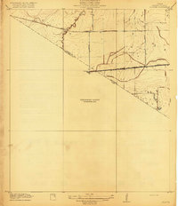 1919 Clodine1919 Print · USGSThe coastal prairie of the Harris and Fort Bend county line is captured here just before the era of major flood control. Genealogists can trace early settlements like Clodine and Howell alongside the remnant Texas Western RR (Abandoned) rail bed.3 unique versions available
End of results
Showing maps 1-3 of 3
Top cities near Sugar Land
- Houston historical maps
- Pearland historical maps
- Missouri City historical maps
- Rosenberg historical maps
- Alvin historical maps
- Fresno historical maps
See more
Top neighborhoods of Sugar Land
- Herbert historical maps
- Paynes historical maps
- First Colony historical maps
- New Territory historical maps
- Greatwood historical maps
Frequently asked questions
- What are the different types of historical maps available for Sugar Land?
- What is the oldest map of Sugar Land?
- Where can I purchase historical maps of Sugar Land for my home or office?
- Where can I download high-res historical maps of Sugar Land?
- Are there historical topographic maps available for Sugar Land?
- Is there historical aerial imagery available for Sugar Land?
- Where are historical maps of Sugar Land sourced from?