1940s Maps of Galveston County, Texas
Explore 18 historic maps of Galveston County from the 1940s. These maps offer a rare glimpse into what life looked like during the 1940s — showing old roads, neighborhoods, homes, and landmarks that have changed or disappeared over time.
Whether you're researching your family's past, planning a metal detecting trip, or studying how Galveston County's landscape evolved across the 1940s, these high-resolution maps are a powerful tool for exploring the history of this region.
- Focus on a specific era: All maps on this page are from the 1940s, giving you a focused view of this time period.
- See what’s changed: Compare century-old streets, trails, and buildings to today's modern landscape using overlays and satellite layers.
- Research with precision: Use these maps for genealogy, historical research, land use analysis, or educational projects.
- View, download, or print: Maps are fully viewable online in high resolution, and can be downloaded or printed for your own records.
Start exploring Galveston County's history through authentic maps from the 1940s. This is your window into the past.
Galveston County, TX maps
(18)- 1943 Map of San Luis Pass
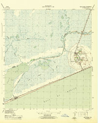
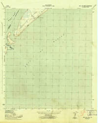 1943 San Luis Pass1943 Print · USGSCoastal Galveston during the war years focused on maritime defense and navigation at the mouth of the bay. Researchers can trace the early layout of West Beach and the location of the San Luis Coast Guard Station at San Luis Pass.3 unique versions available
 - 1943 Map of Virginia Point
 1943 Virginia Point1943 Print · USGSGalveston County was a hive of industrial and maritime activity during the war years. Local historians can trace the critical rail lines of the Santa Fe and the strategic connection at Virginia Point leading toward Galveston Island.2 unique versions available
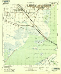
 - 1943 Map of Texas City
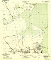 1943 Texas City1943 Print · USGSThe Galveston Bay shoreline and the industrial expansion of the Texas City area are captured in detail during the early 1940s. Genealogists and local historians can trace the early layouts of Lamarque, the waterfront at San Leon, and the rail infrastructure of the Southern Pacific.2 unique versions available
 - 1943 Map of Lake Como
 1943 Lake Como1943 Print · USGSGalveston Island's central reaches are shown here in the early 1940s, highlighting the natural drainage systems and coastal topography. Trace the early road network from Eight Mile Road to Thirteen Mile Road while exploring landmarks like the Lookout Tower and Lake Como.2 unique versions available
 - 1943 Map of High Island
 1943 High Island1943 Print · USGSCoastal Texas during the early 1940s reveals a landscape of vital waterways and isolated gulf settlements. Genealogists and researchers can trace the routes of the Santa Fe railroad and Intracoastal Waterway near High Island and Gilchrist.2 unique versions available
 - 1943 Map of Flake
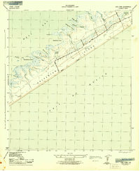
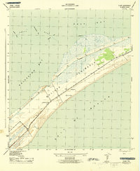 1943 Flake1943 Print · USGSThe Bolivar Peninsula appears here during the early 1940s, showing its vital coastal role between the Gulf and the Galveston Bay system. Historians can trace the wartime landscape near Flake, including the Lookout Tower and Port Bolivar Cem.2 unique versions available
 - 1943 Map of Mustang Bayou
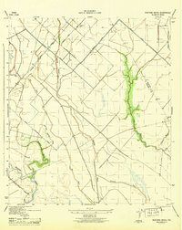 1943 Mustang Bayou1943 Print · USGSThe coastal prairie south of Houston during the 1940s reveals a landscape of tidal bayous and early irrigation. Genealogists and historians can trace the Missouri Pacific Road and find landmarks like the German Cem and Briscoe Canal.2 unique versions available
 - 1943 Map of Port Bolivar, 1952 Print
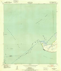
 1943 Port Bolivar1952 Print · USGSGalveston Bay and the Bolivar Peninsula are captured here during the mid-forties, showing a landscape defined by maritime defense and industrial shipping. Researchers can locate Fort Travis, the Texas City Dike, and the early layout of Port Bolivar.
 - 1943 Map of Frozen Point, 1952 Print
 1943 Frozen Point1952 Print · USGSThe Texas coast near the Bolivar Peninsula is captured here during the early forties, showing a landscape defined by expansive salt marshes and new industrial waterways. Researchers can trace the development of the Intracoastal Waterway and locate early sites like Rollover and the Sun Oil Company Canal.
 - 1943 Map of Smith Point, 1952 Print
 1943 Smith Point1952 Print · USGSCoastal Chambers County is captured here during the 1940s, showing the strategic maritime convergence of three major bays. Marine researchers and genealogists can trace early industrial markers like oil wells and windmills near the Smith Point settlement and the Vingt-et-un Islands.3 unique versions available
 - 1943 Map of Clifton By The Sea, 1952 Print
 1943 Clifton By The Sea1952 Print · USGSThe western shores of Galveston Bay come alive in the 1940s, showcasing early coastal developments and maritime industry. Trace old waterfront family sites at Clifton by the Sea and San Leon, or locate historic burials at Harris Cem and Seabrook Cem.
 - 1943 Map of The Jetties, 1952 Print
 1943 The Jetties1952 Print · USGSThe Galveston coastline during the early 1940s reveals the intricate maritime engineering used to guide ships through the Bolivar Roads. Trace the alignment of the South Jetty Lighthouse and North Jetty Light guarding the Outer Bar Channel.
 - 1943 Map of Carancahua Lake, 1952 Print
 1943 Carancahua Lake1952 Print · USGSThe Galveston and Brazoria county line met in the tidal marshes and open waters of the West Bay during the 1940s. Researchers can trace the early path of the Intracoastal Waterway and locate landmarks like Rattlesnake Mound and Boathouse Ruins.
 - 1943 Map of Lake Stephenson, 1952 Print
 1943 Lake Stephenson1952 Print · USGSChambers County coastal marshes are captured in detail in the 1940s, highlighting the remote settlements of the Texas shoreline. Genealogists and historians can locate family landmarks like the Frankland Cemetery, Smith Point School, and Lake Surprise.
 - 1943 Map of Galveston, 1952 Print
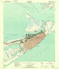 1943 Galveston1952 Print · USGSGalveston at the height of the mid-century maritime era is a dense landscape of coastal defenses and rail terminals. Researchers can trace the legacy of the Southern Pacific lines or locate old military installations like Old Fort San Jacinto and Fort Crockett.
 - 1943 Map of Caplen, 1953 Print
 1943 Caplen1953 Print · USGSThe Bolivar Peninsula during the wartime era shows a shift from maritime isolation toward oil extraction and coastal defense. Researchers can trace the early petroleum footprint at Oil Wells, find the local Cem, and locate the Coast Guard Station near Caplen.
 - 1943 Map of Dickinson, 1953 Print
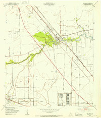 1943 Dickinson1953 Print · USGSCoastal Galveston County comes alive during the war years, showing a landscape defined by military sites and the winding Dickinson Bayou. You can trace family roots at Arcadia, locate the Santa Fe Consolidated Sch, and explore the layout of Camp Wallace.
 - 1943 Map of Christmas Point, 1958 Print
 1943 Christmas Point1958 Print · USGSThe Texas Gulf Coast at Christmas Bay appears here in the 1940s, showing a landscape of barrier islands and marshy bayous. Trace the historic route of the Intracoastal Waterway and locate early landmarks like Christmas Point and Rattlesnake Point.
End of results
Showing maps 1-18 of 18
Top cities of Galveston County
- League City historical maps
- Galveston historical maps
- Texas City historical maps
- Dickinson historical maps
- La Marque historical maps
- Santa Fe historical maps
See more
Frequently asked questions
- What are the different types of historical maps available for Galveston County?
- What is the oldest map of Galveston County?
- Where can I purchase historical maps of Galveston County for my home or office?
- Where can I download high-res historical maps of Galveston County?
- Are there historical topographic maps available for Galveston County?
- Is there historical aerial imagery available for Galveston County?
- Where are historical maps of Galveston County sourced from?