Old Maps of Galveston County, Texas for Metal Detecting
Plan your next treasure hunt with 134 historic maps of Galveston County. Find old homesites, ghost towns, trails, and gathering spots that may be lost to time — perfect for identifying promising metal detecting locations.
- Locate forgotten sites: Uncover places like long-lost settlements, abandoned rail lines, or gathering spots.
- Plan better hunts: Use map overlays combined with LiDAR or satellite views to narrow in on historically rich areas.
- Made for detectorists: Thousands of hobbyists use these maps to discover relics, coins, and hidden history.
Use these historic maps to boost your research and find new opportunities beneath the surface of Galveston County.
Galveston County, TX maps
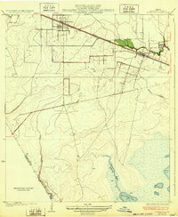
(134)- 1916 Map of Genoa
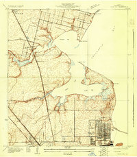
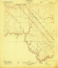 1916 Genoa1916 Print · USGSSoutheast Texas coastal prairie development is captured here during the First World War era, showing the intersection of early electric rail and county life. Trace the old routes of the Galveston Houston Electric or locate the Friendswood Bridge and Genoa Sta along the Harris County line.2 unique versions available
 - 1916 Map of Seabrook
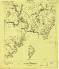 1916 Seabrook1916 Print · USGSThe Galveston Bay shoreline comes to life in the years before heavy industrialization, showing the early coastal developments of Seabrook and Bayview. Genealogists can trace the Old Middle Bayou School and early rail lines like the Galveston Houston Electric Ry.2 unique versions available
 - 1920 Map of Seabrook
 1920 Seabrook1920 Print · USGSCoastal Harris County near the end of the Great War was a network of bayous and new rail lines. Genealogists and local historians can locate early landmarks like the Old Middle Bayou School, the Clear Lake Inn, and the transit hub at Webster.
 - 1920 Map of Genoa
 1920 Genoa1920 Print · USGSSoutheast Texas at the end of the Great War shows a landscape defined by new airfields and electric transit. Genealogists and historians can trace the early rail corridor serving Genoa, the initial layout of Ellington Field, and the crossing at Friendswood Bridge.
 - 1929 Map of Dickinson
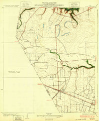
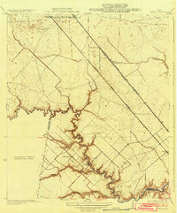
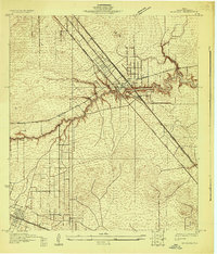 1929 Dickinson1929 Print · USGSGalveston County is captured here in the late twenties, showing a landscape defined by tidewater bayous and competing transit lines. Trace early rail corridors like the Missouri Pacific and find local landmarks such as Arcadia and the Santa Fe Sch.
 - 1929 Map of Karankawa Lake
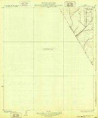
 1929 Karankawa Lake1929 Print · USGSThe Galveston and Brazoria county line meets the Gulf Coast in the late 1920s, revealing an era of undeveloped marshland and barrier island terrain. Researchers can trace the shifting shoreline of Galveston Island and identify historical landmarks like Karankawa Lake and Halls.
 - 1929 Map of Algoa
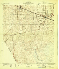
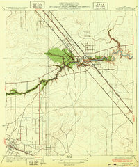
 1929 Algoa1929 Print · USGSThe coastal plains of Galveston County come into focus during the late twenties as the rail economy of Algoa took shape. Genealogists and historians can trace the early path of the Gulf Colorado and Santa Fe and locate unique geological Gas Bumps.
 - 1929 Map of Hitchcock
 1929 Hitchcock1929 Print · USGSCoastal Galveston County is captured here in the late twenties, showing the transition from inland prairie to marshy bayou. Genealogists and historians can trace early infrastructure along the Gulf Colorado and Santa Fe Railway near Hitchcock and Alta Loma.
 - 1929 Map of Virginia Point
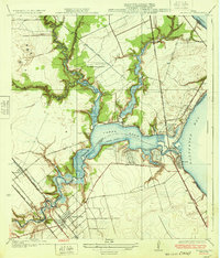
 1929 Virginia Point1929 Print · USGSThe Galveston shoreline in the late twenties was a hub of heavy industry and rail transport as the region expanded toward the mainland. Family historians can trace the early layout of La Marque and the dense rail junctions at Texas City Junction and Virginia Point.
 - 1929 Map of Texas City
 1929 Texas City1929 Print · USGSCoastal Galveston County is caught in a moment of early industrial and transit growth during the late twenties. Genealogists and historians can trace the early grids of Texas City and Lamarque, or locate coastal landmarks like Clifton By the Sea and April Fool Point.
 - 1930 Map of Galveston
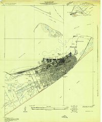 1930 Galveston1930 Print · USGSGalveston thrived as a premier Gulf port and rail terminus during the interwar years. Genealogists and maritime historians can trace the harbor's layout through Union Station, the Fort Crockett Flying Field, and the Immigrant Station.
 - 1931 Map of Lake Como
 1931 Lake Como1931 Print · USGSGalveston Island's coastal geography is shown in the early 1930s just as aerial mapping was coming into its own. Local historians can trace the early settlement at Dana and the natural shorelines of Lake Como and Sweetwater Lake before modern expansion.
 - 1931 Map of Flake
 1931 Flake1931 Print · USGSGalveston County's coastal landscape appears in 1931 as a network of rail lines and marshes on the Bolivar Peninsula. Researchers can trace the early footprint of the Flake settlement and locate landmarks like Parrs Grove and Elm Grove.
 - 1931 Map of High Island
 1931 High Island1931 Print · USGSCoastal Texas in the early thirties reveals a landscape of salt domes and rail-linked settlements along the gulf. Trace the early footprint of High Island, the railroad at Gilchrist Sta, and the historic High Island Hotel before the era of modern development.
 - 1931 Map of Frozen Point
 1931 Frozen Point1931 Print · USGSCoastal Chambers and Galveston counties are shown in the early 1930s just as aerial photography began to modernize mapping. Trace the shoreline of East Bay and the rail line of the Gulf Colorado and Santa Fe at Frozen Point.
 - 1932 Map of Algoa
 1932 Algoa1932 Print · USGSCoastal Texas in the early thirties centers on the railroad junction at Algoa, where steam-era transportation met the early automotive age. Genealogists and historians can trace the crossing of the Missouri Pacific and Gulf Colorado and Santa Fe near Dickinson Bayou.3 unique versions available
 - 1932 Map of Clifton By The Sea
 1932 Clifton By The Sea1932 Print · USGSThe Texas coastline along Galveston Bay appears in the early 1930s as a landscape of maritime navigation and rail-side settlements. Genealogists and historians can trace the streets of Clifton by the Sea and locate the Red Fish Bar L H lighthouse.2 unique versions available
 - 1932 Map of Genoa
 1932 Genoa1932 Print · USGSSoutheast Texas coastal prairie life in the early thirties is defined by emerging aviation and rail corridors. Genealogists can trace family footprints near Genoa or find the early layout of Olcott (Ellington Field) and the Friendswood Bridge.3 unique versions available
 - 1932 Map of Dickinson
 1932 Dickinson1932 Print · USGSGalveston County was a bustling hub of rail and road traffic in the early thirties, centered on the winding waters of the Dickinson Bayou. Researchers can trace the routes of the Houston Galveston Electric line and locate local landmarks like the Santa Fe Sch in Arcadia.2 unique versions available
 - 1932 Map of Seabrook
 1932 Seabrook1932 Print · USGSThe Texas coastline between Houston and Galveston appears here in the early thirties, showcasing the growth of bayside communities. Genealogists and local historians can trace the early footprints of Seabrook, Kemah, and League City, or locate the Old Middle Bayou School and the Clear Lake Inn.3 unique versions available
 - 1932 Map of Texas City
 1932 Texas City1932 Print · USGSThe Galveston County coast in the early 1930s shows a landscape defined by rail lines and nascent port infrastructure. Genealogists and historians can trace the early grids of Texas City and locate coastal communities like Clifton by the Sea and San Leon.2 unique versions available
 - 1932 Map of Bolivar Point
 1932 Bolivar Point1932 Print · USGSThe tip of the Bolivar Peninsula is captured in the early 1930s just as aerial surveying began to transform coastal mapping. Researchers can trace the path of the G C & S F railroad near Bolivar Point or study the shoals of Hannah Reef.
 - 1932 Map of Hitchcock
 1932 Hitchcock1932 Print · USGSThe coastal prairies of Galveston County come into focus during the early thirties as rail and ranching shaped the landscape. Genealogists and local researchers can trace early settlements at Hitchcock and Alta Loma, or locate the Galveston Memorial Cemetery near the banks of Highland Bayou.2 unique versions available
 - 1932 Map of Mustang Bayou
 1932 Mustang Bayou1932 Print · USGSThe coastal prairie of the upper Gulf Coast is captured here in the early thirties as local officials began formalizing land boundaries. Genealogists and historians can trace the early layout of Arcadia and the boundary between Galveston Co and Brazoria Co.2 unique versions available
 - 1932 Map of Virginia Point, 1943 Print
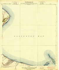
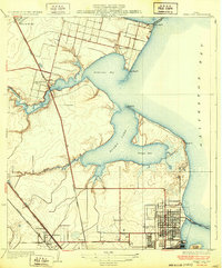
 1932 Virginia Point1943 Print · USGSThe Galveston mainland in the late twenties was a hub of industrial transit, dominated by rail lines converging at the shore. Trace the path of the Interurban and Southern Pacific as they reach Virginia Point and the Galveston Causeway.
Showing maps 1-25 of 134
Top cities of Galveston County
- League City historical maps
- Galveston historical maps
- Texas City historical maps
- Dickinson historical maps
- La Marque historical maps
- Santa Fe historical maps
See more
Frequently asked questions
- What are the different types of historical maps available for Galveston County?
- What is the oldest map of Galveston County?
- Where can I purchase historical maps of Galveston County for my home or office?
- Where can I download high-res historical maps of Galveston County?
- Are there historical topographic maps available for Galveston County?
- Is there historical aerial imagery available for Galveston County?
- Where are historical maps of Galveston County sourced from?