1990s Maps of Galveston County, Texas
Explore 19 historic maps of Galveston County from the 1990s. These maps offer a rare glimpse into what life looked like during the 1990s — showing old roads, neighborhoods, homes, and landmarks that have changed or disappeared over time.
Whether you're researching your family's past, planning a metal detecting trip, or studying how Galveston County's landscape evolved across the 1990s, these high-resolution maps are a powerful tool for exploring the history of this region.
- Focus on a specific era: All maps on this page are from the 1990s, giving you a focused view of this time period.
- See what’s changed: Compare century-old streets, trails, and buildings to today's modern landscape using overlays and satellite layers.
- Research with precision: Use these maps for genealogy, historical research, land use analysis, or educational projects.
- View, download, or print: Maps are fully viewable online in high resolution, and can be downloaded or printed for your own records.
Start exploring Galveston County's history through authentic maps from the 1990s. This is your window into the past.
Galveston County, TX maps
(19)- 1992 Map of Houston
 1992 Houston1992 Print · USGSThe Houston metropolitan area reached its modern sprawl in the early nineties, centered on the Buffalo Bayou and a massive regional rail network. Genealogists and historians can trace the development of satellite cities like Sugar Land and Pasadena, or locate legacy sites like the Humble Oil Field and the NASA Lyndon B Johnson Space Center.
 - 1993 Map of Bacliff
 1993 Bacliff1993 Print · USGSThe Galveston Bay shoreline in the early nineties reveals a landscape of growing coastal communities and offshore energy production. Genealogists and local historians can map out residential areas like Bacliff and San Leon or locate landmarks such as Bayshore Church and the Houston Yacht Club.
 - 1993 Map of Smith Point, 1994 Print
 1993 Smith Point1994 Print · USGSThe Texas Gulf Coast at the convergence of three bays is captured here in the early 1990s. Trace local history through family-named landmarks like Davis Cem or explore the vast offshore industry at Umbrella Point Oil Field and Redfish Reef.
 - 1994 Map of Lake Stephenson
 1994 Lake Stephenson1994 Print · USGSThe Texas coastline at the edge of Chambers and Galveston counties was a landscape of dense wetlands and active energy extraction in the 1990s. Researchers can locate the Frankland Cem or trace the early oil and gas industry through the Oil Wells peppered across Gordy Marsh.
 - 1994 Map of Mud Lake
 1994 Mud Lake1994 Print · USGSThe Texas coastline in the mid-nineties reveals a landscape of protected wetlands and vital shipping channels. Researchers can trace the intersection of the Intracoastal Waterway and the expansive Mc Faddin National Wildlife Refuge.
 - 1994 Map of The Jetties
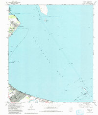
 1994 The Jetties1994 Print · USGSThe Galveston harbor entrance in the mid-nineties shows the critical infrastructure connecting Texas to the sea. Maritime researchers can trace the expansive North Jetty and South Jetty or locate coastal landmarks like Apffel Park and the Galveston Jetty Light.
 - 1994 Map of Galveston
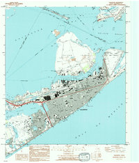 1994 Galveston1994 Print · USGSThe island city of Galveston and the Bolivar Peninsula are shown here in the mid-1990s, capturing the dense urban grid and maritime infrastructure. Researchers can locate specific sites like City Cem, the Old Fort San Jacinto (Site), and Moody Gardens.
 - 1994 Map of Caplen
 1994 Caplen1994 Print · USGSThe Bolivar Peninsula during the mid-1990s reveals a narrow landscape shaped by the Gulf and the Intracoastal Waterway. Researchers can trace the energy infrastructure of the Caplen Oil Field or locate the Indian Graveyard and Crystal Beach settlements.
 - 1994 Map of Frozen Point
 1994 Frozen Point1994 Print · USGSCoastal Texas marshes and the barrier islands of Chambers County are captured here during the 1990s. Researchers can trace the industrial footprints of the Sun Oil Company Canal and Oil Wells alongside settlements like Caplen and Pierce.
 - 1994 Map of Port Bolivar
 1994 Port Bolivar1994 Print · USGSThe Texas coast at the tip of the Bolivar Peninsula comes into focus in the mid-nineties, showing the heavy industrial maritime corridors. Trace the path of the Houston Ship Channel or locate local landmarks like the Old Railroad Gr and Horseshoe Lake.
 - 1994 Map of High Island
 1994 High Island1994 Print · USGSThe Texas coastline at the Galveston and Chambers county line appears here in the mid-nineties, showing the salt dome geology of the region. Researchers can trace the Oil Field infrastructure near High Island or locate the coastal community of Gilchrist near Rollover Bay.
 - 1994 Map of Texas City
 1994 Texas City1994 Print · USGSTexas City and the Galveston Bay shoreline are captured here in the mid-1990s, showcasing a landscape of industrial infrastructure and coastal protection. Genealogists and historians can trace neighborhood developments like Bacliff and San Leon, or locate family markers at Texas City Memorial Cem and Phillips Memorial Cem.
 - 1994 Map of Virginia Point
 1994 Virginia Point1994 Print · USGSThe Texas Gulf Coast in the early nineties shows the dense intersection of industrial shipping and modern canal-front living. Trace the transition from the mainland to Galveston Island via Virginia Point, or locate local landmarks like Lamar Cem and the Village of Tiki Island.
 - 1994 Map of Flake
 1994 Flake1994 Print · USGSThe Bolivar Peninsula in the late eighties shows a dynamic coastal landscape of resort growth and maritime industry. Trace the legacy of this barrier strip through the Port Bolivar Cemetery, the Old Railroad Grade, and the bayside reaches of Goat Island.
 - 1994 Map of Lake Como
 1994 Lake Como1994 Print · USGSGalveston Island's western reach is shown in the mid-1990s, where residential growth meets protected coastal marshes. Researchers can trace the development of Jamaica Beach or locate historical landmarks like Lafitte Grove and the Mary Moody Northern Amphitheater Footbridge.
 - 1995 Map of League City, 1998 Print
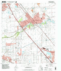
 1995 League City1998 Print · USGSCoastal Harris and Galveston Counties in the mid-nineties show the meeting point of space-age industry and bayside living. Genealogists and historians can trace the growth of League City and find local landmarks like Fairview Cem and the Houston Gulf Airport.
 - 1995 Map of Dickinson, 1999 Print
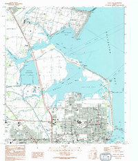
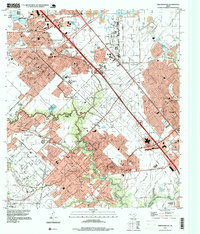
 1995 Dickinson1999 Print · USGSCoastal Galveston County is captured here during a period of significant suburban and industrial growth. Researchers can trace the legacy of Camp Wallace, locate the Mt Olivet Cemetery, and explore the reaches of Dickinson Bayou.
 - 1995 Map of Friendswood, 1999 Print
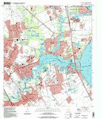
 1995 Friendswood1999 Print · USGSCoastal Texas industry and suburban growth converge south of Houston in the mid-1990s as oil fields meet new residential subdivisions. Genealogists and historians can trace the development of Friendswood and Pearland alongside Whitcomb Cem and the Friendswood Oil Field.
 - 1995 Map of Virginia Point, 2000 Print
 1995 Virginia Point2000 Print · USGSThe Texas Gulf Coast comes into focus in the mid-nineties as industrial centers and master-planned waterfront communities expand toward the bay. Genealogists and historians can trace the development of Tiki Island and find local landmarks like La Marque Cem and Texas City Terminal Junction.
End of results
Showing maps 1-19 of 19
Top cities of Galveston County
- League City historical maps
- Galveston historical maps
- Texas City historical maps
- Dickinson historical maps
- La Marque historical maps
- Santa Fe historical maps
See more
Frequently asked questions
- What are the different types of historical maps available for Galveston County?
- What is the oldest map of Galveston County?
- Where can I purchase historical maps of Galveston County for my home or office?
- Where can I download high-res historical maps of Galveston County?
- Are there historical topographic maps available for Galveston County?
- Is there historical aerial imagery available for Galveston County?
- Where are historical maps of Galveston County sourced from?