1960s Maps of Texas City, Texas
Explore 2 historic maps of Texas City from the 1960s. These maps offer a rare glimpse into what life looked like during the 1960s — showing old roads, neighborhoods, homes, and landmarks that have changed or disappeared over time.
Whether you're researching your family's past, planning a metal detecting trip, or studying how Texas City's landscape evolved across the 1960s, these high-resolution maps are a powerful tool for exploring the history of this region.
- Focus on a specific era: All maps on this page are from the 1960s, giving you a focused view of this time period.
- See what’s changed: Compare century-old streets, trails, and buildings to today's modern landscape using overlays and satellite layers.
- Research with precision: Use these maps for genealogy, historical research, land use analysis, or educational projects.
- View, download, or print: Maps are fully viewable online in high resolution, and can be downloaded or printed for your own records.
Start exploring Texas City's history through authentic maps from the 1960s. This is your window into the past.
Texas City, TX maps
(2)- 1961 Map of Smith Point, 1964 Print
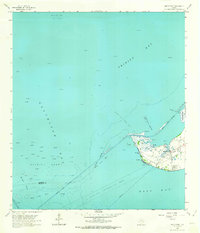 1961 Smith Point1964 Print · USGSThe tip of Chambers County at the start of the 1960s shows a landscape transformed by the offshore energy boom. Genealogists and local historians can trace family markers at Davis Cem or locate old industrial landmarks like Morgan Pt and Red Fish Bar.2 unique versions available
 - 1961 Map of Lake Stephenson, 1964 Print
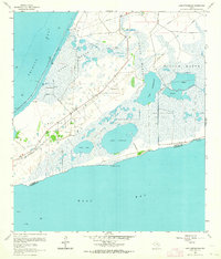 1961 Lake Stephenson1964 Print · USGSThe Texas coastline in the early sixties reveals a landscape of industrial extraction and wetlands between Trinity Bay and East Bay. Trace petroleum history through the White Lake Oil Field or locate the Frankland Cem among the marshlands.2 unique versions available
End of results
Showing maps 1-2 of 2
Top cities near Texas City
- Houston historical maps
- Pasadena historical maps
- League City historical maps
- Galveston historical maps
- La Porte historical maps
- Alvin historical maps
See more
Top neighborhoods of Texas City
- Texas City Junction historical maps
- Nadeau historical maps
- Heights historical maps
- Virginia Point historical maps
- Lago Mar historical maps
Frequently asked questions
- What are the different types of historical maps available for Texas City?
- What is the oldest map of Texas City?
- Where can I purchase historical maps of Texas City for my home or office?
- Where can I download high-res historical maps of Texas City?
- Are there historical topographic maps available for Texas City?
- Is there historical aerial imagery available for Texas City?
- Where are historical maps of Texas City sourced from?