Old Maps of Texas City, Texas for Hiking & Exploration
Hike through history with 59 historic maps of Texas City. Explore old trails, ghost towns, and forgotten backroads — perfect for outdoor adventurers and local explorers.
- Rediscover forgotten places: Map out old mining camps, roads, and footpaths that no longer exist on modern maps.
- Layer with modern tools: Combine with LiDAR or satellite views to plan hikes through historical terrain.
- Made for exploration: Popular among hikers, overlanders, and local history lovers.
Use these maps to find adventure and explore the hidden past of Texas City.
Texas City, TX maps
(59)- 1929 Map of Dickinson
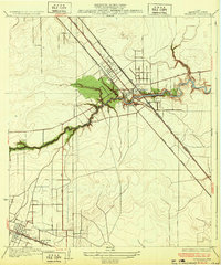
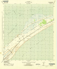
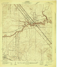 1929 Dickinson1929 Print · USGSGalveston County is captured here in the late twenties, showing a landscape defined by tidewater bayous and competing transit lines. Trace early rail corridors like the Missouri Pacific and find local landmarks such as Arcadia and the Santa Fe Sch.
 - 1929 Map of Virginia Point
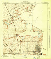
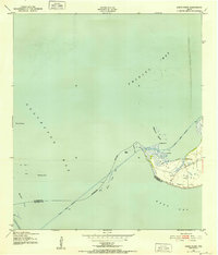
 1929 Virginia Point1929 Print · USGSThe Galveston shoreline in the late twenties was a hub of heavy industry and rail transport as the region expanded toward the mainland. Family historians can trace the early layout of La Marque and the dense rail junctions at Texas City Junction and Virginia Point.
 - 1929 Map of Texas City
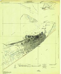
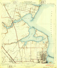
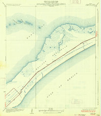
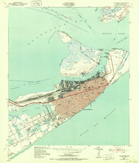
 1929 Texas City1929 Print · USGSCoastal Galveston County is caught in a moment of early industrial and transit growth during the late twenties. Genealogists and historians can trace the early grids of Texas City and Lamarque, or locate coastal landmarks like Clifton By the Sea and April Fool Point.
 - 1930 Map of Galveston
 1930 Galveston1930 Print · USGSGalveston thrived as a premier Gulf port and rail terminus during the interwar years. Genealogists and maritime historians can trace the harbor's layout through Union Station, the Fort Crockett Flying Field, and the Immigrant Station.
 - 1931 Map of Flake
 1931 Flake1931 Print · USGSGalveston County's coastal landscape appears in 1931 as a network of rail lines and marshes on the Bolivar Peninsula. Researchers can trace the early footprint of the Flake settlement and locate landmarks like Parrs Grove and Elm Grove.
 - 1932 Map of Clifton By The Sea
 1932 Clifton By The Sea1932 Print · USGSThe Texas coastline along Galveston Bay appears in the early 1930s as a landscape of maritime navigation and rail-side settlements. Genealogists and historians can trace the streets of Clifton by the Sea and locate the Red Fish Bar L H lighthouse.2 unique versions available
 - 1932 Map of Dickinson
 1932 Dickinson1932 Print · USGSGalveston County was a bustling hub of rail and road traffic in the early thirties, centered on the winding waters of the Dickinson Bayou. Researchers can trace the routes of the Houston Galveston Electric line and locate local landmarks like the Santa Fe Sch in Arcadia.2 unique versions available
 - 1932 Map of Texas City
 1932 Texas City1932 Print · USGSThe Galveston County coast in the early 1930s shows a landscape defined by rail lines and nascent port infrastructure. Genealogists and historians can trace the early grids of Texas City and locate coastal communities like Clifton by the Sea and San Leon.2 unique versions available
 - 1932 Map of Bolivar Point
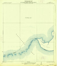
 1932 Bolivar Point1932 Print · USGSThe tip of the Bolivar Peninsula is captured in the early 1930s just as aerial surveying began to transform coastal mapping. Researchers can trace the path of the G C & S F railroad near Bolivar Point or study the shoals of Hannah Reef.
 - 1932 Map of Virginia Point, 1943 Print
 1932 Virginia Point1943 Print · USGSThe Galveston mainland in the late twenties was a hub of industrial transit, dominated by rail lines converging at the shore. Trace the path of the Interurban and Southern Pacific as they reach Virginia Point and the Galveston Causeway.
 - 1933 Map of Whites Lake
 1933 Whites Lake1933 Print · USGSThe Galveston County coastline at the start of the 1930s is preserved in this maritime-focused survey. Researchers can trace the early county boundary at Stevenson Point and the interface between Galveston Bay and East Bay.
 - 1933 Map of Smith Point
 1933 Smith Point1933 Print · USGSCoastal Chambers County is captured here in the early 1930s, showing the intricate shoreline and maritime boundaries of Galveston Bay. Map collectors can trace the shifting sands and channels of Fish Bar, Possum Pass, and Red Pass.2 unique versions available
 - 1933 Map of Bolivar Point
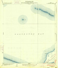 1933 Bolivar Point1933 Print · USGSGalveston Bay and the Bolivar Peninsula are captured here in the early 1930s as vital maritime and rail corridors. Researchers can trace the path of the G C & S F railroad toward Bolivar Point or examine the reach of the Texas City Dike.2 unique versions available
 - 1933 Map of Flake
 1933 Flake1933 Print · USGSThe Texas coast at the Bolivar Peninsula is captured here in the early 1930s as a corridor of rail and road. Researchers can trace the early path of the Gulf Colorado and Santa Fe railroad and the small settlement at Flake.2 unique versions available
 - 1933 Map of Galveston, 1943 Print
 1933 Galveston1943 Print · USGSGalveston and the Bolivar Peninsula are shown in the early 1930s as a major hub for rail, sea, and military defense. Trace the dense network of rail lines ending at Union Sta, the numerous harbor docks, and coastal fortifications like Fort Crockett and Fort Travis.
 - 1943 Map of Virginia Point
 1943 Virginia Point1943 Print · USGSGalveston County was a hive of industrial and maritime activity during the war years. Local historians can trace the critical rail lines of the Santa Fe and the strategic connection at Virginia Point leading toward Galveston Island.2 unique versions available
 - 1943 Map of Texas City
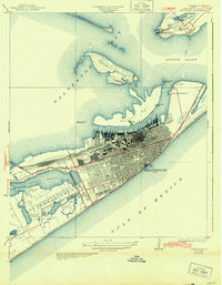
 1943 Texas City1943 Print · USGSThe Galveston Bay shoreline and the industrial expansion of the Texas City area are captured in detail during the early 1940s. Genealogists and local historians can trace the early layouts of Lamarque, the waterfront at San Leon, and the rail infrastructure of the Southern Pacific.2 unique versions available
 - 1943 Map of Flake
 1943 Flake1943 Print · USGSThe Bolivar Peninsula appears here during the early 1940s, showing its vital coastal role between the Gulf and the Galveston Bay system. Historians can trace the wartime landscape near Flake, including the Lookout Tower and Port Bolivar Cem.2 unique versions available
 - 1943 Map of Port Bolivar, 1952 Print
 1943 Port Bolivar1952 Print · USGSGalveston Bay and the Bolivar Peninsula are captured here during the mid-forties, showing a landscape defined by maritime defense and industrial shipping. Researchers can locate Fort Travis, the Texas City Dike, and the early layout of Port Bolivar.
 - 1943 Map of Smith Point, 1952 Print
 1943 Smith Point1952 Print · USGSCoastal Chambers County is captured here during the 1940s, showing the strategic maritime convergence of three major bays. Marine researchers and genealogists can trace early industrial markers like oil wells and windmills near the Smith Point settlement and the Vingt-et-un Islands.3 unique versions available
 - 1943 Map of Clifton By The Sea, 1952 Print
 1943 Clifton By The Sea1952 Print · USGSThe western shores of Galveston Bay come alive in the 1940s, showcasing early coastal developments and maritime industry. Trace old waterfront family sites at Clifton by the Sea and San Leon, or locate historic burials at Harris Cem and Seabrook Cem.
 - 1943 Map of Lake Stephenson, 1952 Print
 1943 Lake Stephenson1952 Print · USGSChambers County coastal marshes are captured in detail in the 1940s, highlighting the remote settlements of the Texas shoreline. Genealogists and historians can locate family landmarks like the Frankland Cemetery, Smith Point School, and Lake Surprise.
 - 1943 Map of Galveston, 1952 Print
 1943 Galveston1952 Print · USGSGalveston at the height of the mid-century maritime era is a dense landscape of coastal defenses and rail terminals. Researchers can trace the legacy of the Southern Pacific lines or locate old military installations like Old Fort San Jacinto and Fort Crockett.
 - 1943 Map of Dickinson, 1953 Print
 1943 Dickinson1953 Print · USGSCoastal Galveston County comes alive during the war years, showing a landscape defined by military sites and the winding Dickinson Bayou. You can trace family roots at Arcadia, locate the Santa Fe Consolidated Sch, and explore the layout of Camp Wallace.
 - 1950 Map of Houston, 1953 Print
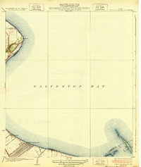
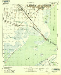
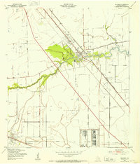
 1950 Houston1953 Print · USGSCoastal Texas in the early fifties reveals a landscape of massive civil engineering and industrial transit. Genealogists and researchers can trace the growth of the Houston suburbs and the maritime infrastructure of Galveston Bay, including the Gulf Freeway and the Texas City Dike.
Showing maps 1-25 of 59
Top cities near Texas City
- Houston historical maps
- Pasadena historical maps
- League City historical maps
- Galveston historical maps
- La Porte historical maps
- Alvin historical maps
See more
Top neighborhoods of Texas City
- Texas City Junction historical maps
- Nadeau historical maps
- Heights historical maps
- Virginia Point historical maps
- Lago Mar historical maps
Frequently asked questions
- What are the different types of historical maps available for Texas City?
- What is the oldest map of Texas City?
- Where can I purchase historical maps of Texas City for my home or office?
- Where can I download high-res historical maps of Texas City?
- Are there historical topographic maps available for Texas City?
- Is there historical aerial imagery available for Texas City?
- Where are historical maps of Texas City sourced from?