1930s Maps of Texas City, Texas
Explore 12 historic maps of Texas City from the 1930s. These maps offer a rare glimpse into what life looked like during the 1930s — showing old roads, neighborhoods, homes, and landmarks that have changed or disappeared over time.
Whether you're researching your family's past, planning a metal detecting trip, or studying how Texas City's landscape evolved across the 1930s, these high-resolution maps are a powerful tool for exploring the history of this region.
- Focus on a specific era: All maps on this page are from the 1930s, giving you a focused view of this time period.
- See what’s changed: Compare century-old streets, trails, and buildings to today's modern landscape using overlays and satellite layers.
- Research with precision: Use these maps for genealogy, historical research, land use analysis, or educational projects.
- View, download, or print: Maps are fully viewable online in high resolution, and can be downloaded or printed for your own records.
Start exploring Texas City's history through authentic maps from the 1930s. This is your window into the past.
Texas City, TX maps
(12)- 1930 Map of Galveston
 1930 Galveston1930 Print · USGSGalveston thrived as a premier Gulf port and rail terminus during the interwar years. Genealogists and maritime historians can trace the harbor's layout through Union Station, the Fort Crockett Flying Field, and the Immigrant Station.
 - 1931 Map of Flake
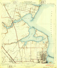
 1931 Flake1931 Print · USGSGalveston County's coastal landscape appears in 1931 as a network of rail lines and marshes on the Bolivar Peninsula. Researchers can trace the early footprint of the Flake settlement and locate landmarks like Parrs Grove and Elm Grove.
 - 1932 Map of Clifton By The Sea
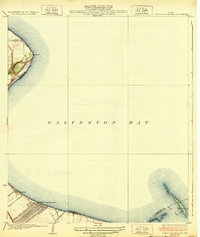 1932 Clifton By The Sea1932 Print · USGSThe Texas coastline along Galveston Bay appears in the early 1930s as a landscape of maritime navigation and rail-side settlements. Genealogists and historians can trace the streets of Clifton by the Sea and locate the Red Fish Bar L H lighthouse.2 unique versions available
 - 1932 Map of Dickinson
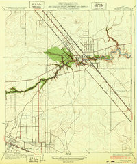 1932 Dickinson1932 Print · USGSGalveston County was a bustling hub of rail and road traffic in the early thirties, centered on the winding waters of the Dickinson Bayou. Researchers can trace the routes of the Houston Galveston Electric line and locate local landmarks like the Santa Fe Sch in Arcadia.2 unique versions available
 - 1932 Map of Texas City
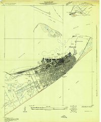
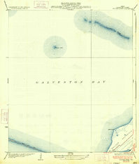
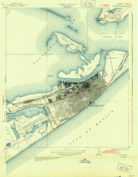
 1932 Texas City1932 Print · USGSThe Galveston County coast in the early 1930s shows a landscape defined by rail lines and nascent port infrastructure. Genealogists and historians can trace the early grids of Texas City and locate coastal communities like Clifton by the Sea and San Leon.2 unique versions available
 - 1932 Map of Bolivar Point
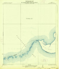
 1932 Bolivar Point1932 Print · USGSThe tip of the Bolivar Peninsula is captured in the early 1930s just as aerial surveying began to transform coastal mapping. Researchers can trace the path of the G C & S F railroad near Bolivar Point or study the shoals of Hannah Reef.
 - 1932 Map of Virginia Point, 1943 Print
 1932 Virginia Point1943 Print · USGSThe Galveston mainland in the late twenties was a hub of industrial transit, dominated by rail lines converging at the shore. Trace the path of the Interurban and Southern Pacific as they reach Virginia Point and the Galveston Causeway.
 - 1933 Map of Whites Lake
 1933 Whites Lake1933 Print · USGSThe Galveston County coastline at the start of the 1930s is preserved in this maritime-focused survey. Researchers can trace the early county boundary at Stevenson Point and the interface between Galveston Bay and East Bay.
 - 1933 Map of Smith Point
 1933 Smith Point1933 Print · USGSCoastal Chambers County is captured here in the early 1930s, showing the intricate shoreline and maritime boundaries of Galveston Bay. Map collectors can trace the shifting sands and channels of Fish Bar, Possum Pass, and Red Pass.2 unique versions available
 - 1933 Map of Bolivar Point
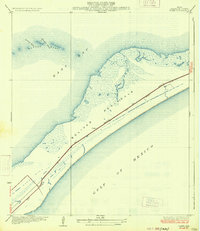
 1933 Bolivar Point1933 Print · USGSGalveston Bay and the Bolivar Peninsula are captured here in the early 1930s as vital maritime and rail corridors. Researchers can trace the path of the G C & S F railroad toward Bolivar Point or examine the reach of the Texas City Dike.2 unique versions available
 - 1933 Map of Flake
 1933 Flake1933 Print · USGSThe Texas coast at the Bolivar Peninsula is captured here in the early 1930s as a corridor of rail and road. Researchers can trace the early path of the Gulf Colorado and Santa Fe railroad and the small settlement at Flake.2 unique versions available
 - 1933 Map of Galveston, 1943 Print
 1933 Galveston1943 Print · USGSGalveston and the Bolivar Peninsula are shown in the early 1930s as a major hub for rail, sea, and military defense. Trace the dense network of rail lines ending at Union Sta, the numerous harbor docks, and coastal fortifications like Fort Crockett and Fort Travis.
End of results
Showing maps 1-12 of 12
Top cities near Texas City
- Houston historical maps
- Pasadena historical maps
- League City historical maps
- Galveston historical maps
- La Porte historical maps
- Alvin historical maps
See more
Top neighborhoods of Texas City
- Texas City Junction historical maps
- Nadeau historical maps
- Heights historical maps
- Virginia Point historical maps
- Lago Mar historical maps
Frequently asked questions
- What are the different types of historical maps available for Texas City?
- What is the oldest map of Texas City?
- Where can I purchase historical maps of Texas City for my home or office?
- Where can I download high-res historical maps of Texas City?
- Are there historical topographic maps available for Texas City?
- Is there historical aerial imagery available for Texas City?
- Where are historical maps of Texas City sourced from?