1960s Maps of Grimes County, Texas
Explore 16 historic maps of Grimes County from the 1960s. These maps offer a rare glimpse into what life looked like during the 1960s — showing old roads, neighborhoods, homes, and landmarks that have changed or disappeared over time.
Whether you're researching your family's past, planning a metal detecting trip, or studying how Grimes County's landscape evolved across the 1960s, these high-resolution maps are a powerful tool for exploring the history of this region.
- Focus on a specific era: All maps on this page are from the 1960s, giving you a focused view of this time period.
- See what’s changed: Compare century-old streets, trails, and buildings to today's modern landscape using overlays and satellite layers.
- Research with precision: Use these maps for genealogy, historical research, land use analysis, or educational projects.
- View, download, or print: Maps are fully viewable online in high resolution, and can be downloaded or printed for your own records.
Start exploring Grimes County's history through authentic maps from the 1960s. This is your window into the past.
Grimes County, TX maps
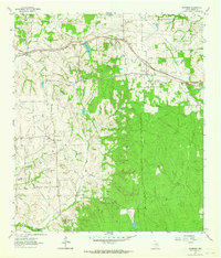
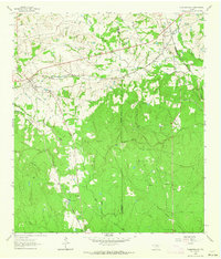
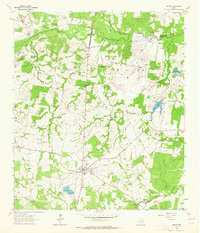
(16)- 1960 Map of Waller NW, 1962 Print
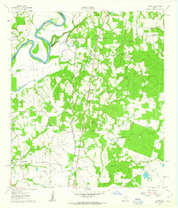
 1960 Waller NW1962 Print · USGSThe rural borderlands of Waller and Harris counties are captured here in the early sixties, showing a landscape of family farms and creek bottoms. You can trace the community heart of the era through sites like Community Hall, Reida Prairie Ch, and Rosenau Cem.2 unique versions available
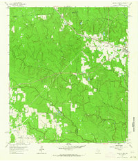
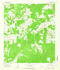
 - 1960 Map of Carlos, 1962 Print
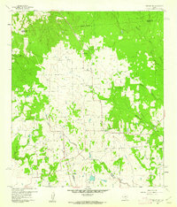
 1960 Carlos1962 Print · USGSIn the early sixties, this area of Grimes County was a mix of quiet ranch land and emerging industry. Genealogists and historians can trace the foundations of Carlos and Piedmont, or locate rural sites like Allen Cem and Blue Lake Ch.4 unique versions available
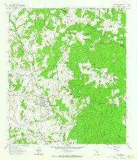
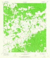
 - 1961 Map of Howth, 1963 Print
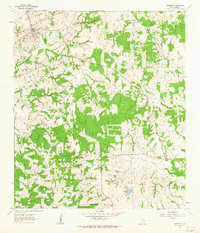
 1961 Howth1963 Print · USGSThe rural Brazos River valley comes to life in the early sixties, centered on the railroad town of Howth. Researchers can trace family history through sites like Salem Cem, St Luke Ch, and the small settlement of Rock Island.2 unique versions available
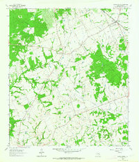
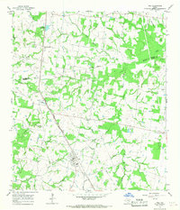
 - 1961 Map of Anderson, 1964 Print
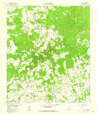
 1961 Anderson1964 Print · USGSGrimes County at the start of the 1960s reveals a landscape of rural schools, historic churches, and winding creek bottoms. Genealogists can trace family footprints at Mason Cem, St Stanislaus Ch, and the site of the Grimes Prairie Sch.2 unique versions available
 - 1961 Map of Stoneham, 1964 Print
 1961 Stoneham1964 Print · USGSGrimes County's rural communities and rail junctions are documented here in the early 1960s. Genealogists and historians can locate family burial grounds like Salem Cem and trace settlements along the MISSOURI PACIFIC rail line such as Yarboro and Stoneham.
 - 1961 Map of Singleton, 1964 Print
 1961 Singleton1964 Print · USGSGrimes County at the start of the sixties reveals a rural landscape defined by heavy rail and creek systems. Genealogists and local historians can trace the junction of the Chicago Rock Island and Pacific Railroad and the Fort Worth and Denver Railroad near Singleton, alongside Zion Hill Ch.2 unique versions available
 - 1962 Map of Dacus, 1963 Print
 1962 Dacus1963 Print · USGSSoutheast Texas at the start of the sixties reveals a transition from the Sam Houston National Forest into the rural creek-side communities of Grimes County. Genealogists can locate family sites near Bethel Cem, Mount Mariah Ch, and the settlement of Dacus.2 unique versions available
 - 1962 Map of Keith, 1964 Print
 1962 Keith1964 Print · USGSIn the early sixties, this portion of Grimes County was a landscape of winding cattle ranches and crossing rail lines. Genealogists can trace family footprints at Enon Cem, the old settlement of Keith, and the Kellum Springs area.2 unique versions available
 - 1962 Map of Plantersville, 1964 Print
 1962 Plantersville1964 Print · USGSPlantersville and its surrounding rail junctions are captured in the early sixties as they served the borderlands of Grimes and Montgomery Counties. Genealogists can trace family names through landmarks like Shannon Cem, Rose Hill Cem, and Center Point Ch.2 unique versions available
 - 1962 Map of Magnolia West, 1964 Print
 1962 Magnolia West1964 Print · USGSSoutheast Texas in the early sixties remains a landscape of timber and creek bottoms where county lines meet. Genealogists and historians can trace family locations near the Old Sanders Cem, the community of Fetzer, and the Lookout Tower Magnolia.3 unique versions available
 - 1962 Map of Richards, 1964 Print
 1962 Richards1964 Print · USGSRichards emerges as a vital railroad junction in the early sixties where two major rail lines met at the edge of the deep pine woods. Researchers can trace family history through sites like Bays Chapel Cem, the local High Sch, and rural landmarks like Robinson Hill.
 - 1962 Map of Roans Prairie, 1964 Print
 1962 Roans Prairie1964 Print · USGSGrimes County ranching and rail junctions come to life in this early 1960s survey of the Texas coastal plains. Genealogists can trace family sites at Roans Prairie Cem or Oakland Cemetery, while historians can follow the Old Railroad Grade.
 - 1963 Map of Bedias, 1964 Print
 1963 Bedias1964 Print · USGSThe rural landscape of southeast Texas is captured here in the early sixties as local life centered around the town of Bedias. Genealogists and researchers can trace family-named locations such as Upchurch and country landmarks like Lone Star Ch and the Old Railroad Grade.
 - 1963 Map of Steep Branch, 1964 Print
 1963 Steep Branch1964 Print · USGSThe rural borderlands of Walker, Madison, and Grimes counties come alive in the early sixties as a landscape of winding creeks and community anchors. Trace family history through landmarks like McAdams Cem, Oak Grove Sch, and the small settlement of Mossy Grove.
 - 1963 Map of Loma, 1965 Print
 1963 Loma1965 Print · USGSWalker County rural life in the early sixties is preserved here, centered on the settlement of Loma. Genealogists and historians can locate numerous community landmarks, from Mc Cowan Cem and Mustang Cem to the Hopewell Sch and Pilgrim Rest Ch.
 - 1965 Map of Iola, 1967 Print
 1965 Iola1967 Print · USGSGrimes and Madison counties are captured here in the mid-sixties, showing a landscape defined by small-town rail stops and rural churches. Genealogists can trace family locations near Iola, Zion Cem, and several country churches like Concord Ch.3 unique versions available
End of results
Showing maps 1-16 of 16
Top cities of Grimes County
Frequently asked questions
- What are the different types of historical maps available for Grimes County?
- What is the oldest map of Grimes County?
- Where can I purchase historical maps of Grimes County for my home or office?
- Where can I download high-res historical maps of Grimes County?
- Are there historical topographic maps available for Grimes County?
- Is there historical aerial imagery available for Grimes County?
- Where are historical maps of Grimes County sourced from?