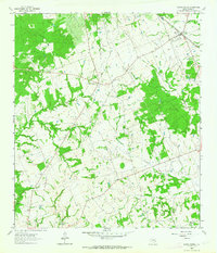
1962 Map of Roans Prairie
USGS Topo · Published 1964About this map
The community of Roans Prairie sits at the junction of several regional routes, serving as a focal point for the surrounding Grimes County ranching and timber lands. By the early 1960s, the landscape here was defined by its transition from older transport methods to modern infrastructure, evidenced by the Old Railroad Grade running north towards Roans Prairie Cem. Active rail lines including the Fort Worth and Denver and the Chicago Rock Island and Pacific pass through Shiro, where the Shiro Cemetery and local Lake mark the northern edge of the settlement. To the south and east, the map reveals a network of rural life tied to the land, featuring the Bethlehem Ch and Arbor Chapel, along with various Quarries and a Gravel Pit. Several creek systems, including Rocky Creek and Garretts Creek, drain the wooded terrain, which is also crossed by significant industrial Pipeline corridors.
Find a feature on this map
19 named features on this map. Tap any name to fly to it.
Don’t see what you’re looking for? This feature index may not catch every label — zoom into the map to look around manually.
Map Details
Editions of this 1962 Roans Prairie Map
This is the sole edition of this map. No revisions or reprints were ever made.
Other maps of this area

1914 · Navasota
USGS Topo · 1:62,500

1954 · Beaumont
USGS Topo · 1:250,000

1954 · Austin
USGS Topo · 1:250,000

1956 · Carlos
USGS Topo · 1:62,500

1957 · Beaumont
USGS Topo · 1:250,000

1958 · Navasota
USGS Topo · 1:24,000

1960 · Carlos
USGS Topo · 1:24,000

1961 · Anderson
USGS Topo · 1:24,000

1961 · Singleton
USGS Topo · 1:24,000

1962 · Dacus
USGS Topo · 1:24,000