1960s Maps of Fall Creek, Texas
Explore 2 historic maps of Fall Creek from the 1960s. These maps offer a rare glimpse into what life looked like during the 1960s — showing old roads, neighborhoods, homes, and landmarks that have changed or disappeared over time.
Whether you're researching your family's past, planning a metal detecting trip, or studying how Fall Creek's landscape evolved across the 1960s, these high-resolution maps are a powerful tool for exploring the history of this region.
- Focus on a specific era: All maps on this page are from the 1960s, giving you a focused view of this time period.
- See what’s changed: Compare century-old streets, trails, and buildings to today's modern landscape using overlays and satellite layers.
- Research with precision: Use these maps for genealogy, historical research, land use analysis, or educational projects.
- View, download, or print: Maps are fully viewable online in high resolution, and can be downloaded or printed for your own records.
Start exploring Fall Creek's history through authentic maps from the 1960s. This is your window into the past.
Fall Creek, TX maps
(2)- 1967 Map of Humble
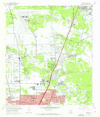 1967 Humble1967 Print · USGSNorthern Harris County is caught in a moment of rapid suburban and industrial expansion in the late sixties. Researchers can trace family sites at Rosewood Park Cem or locate the early footprints of Houston Intercontinental Airport and Douglas MacArthur High Sch.2 unique versions available
 - 1967 Map of Harmaston
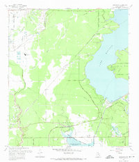 1967 Harmaston1967 Print · USGSNortheast Harris County in the late sixties shows the balance between oil production and the new reservoirs serving the Houston metro area. Genealogists and historians can trace the Missouri Pacific corridor through Harmaston, find the Jacinto Cem, or locate the Riverside Oil Field.2 unique versions available
End of results
Showing maps 1-2 of 2
Top cities near Fall Creek
- Houston historical maps
- Pasadena historical maps
- The Woodlands historical maps
- Atascocita historical maps
- Kingwood historical maps
- Baytown historical maps
See more
Top neighborhoods of Fall Creek
- Autumn Falls historical maps
- Fall Creek historical maps
- Heather Glen historical maps
- Lake Point historical maps
- Magnolia Falls historical maps
- Serrano Creek historical maps
See more
Frequently asked questions
- What are the different types of historical maps available for Fall Creek?
- What is the oldest map of Fall Creek?
- Where can I purchase historical maps of Fall Creek for my home or office?
- Where can I download high-res historical maps of Fall Creek?
- Are there historical topographic maps available for Fall Creek?
- Is there historical aerial imagery available for Fall Creek?
- Where are historical maps of Fall Creek sourced from?