1980s Maps of Fall Creek, Texas
Explore 2 historic maps of Fall Creek from the 1980s. These maps offer a rare glimpse into what life looked like during the 1980s — showing old roads, neighborhoods, homes, and landmarks that have changed or disappeared over time.
Whether you're researching your family's past, planning a metal detecting trip, or studying how Fall Creek's landscape evolved across the 1980s, these high-resolution maps are a powerful tool for exploring the history of this region.
- Focus on a specific era: All maps on this page are from the 1980s, giving you a focused view of this time period.
- See what’s changed: Compare century-old streets, trails, and buildings to today's modern landscape using overlays and satellite layers.
- Research with precision: Use these maps for genealogy, historical research, land use analysis, or educational projects.
- View, download, or print: Maps are fully viewable online in high resolution, and can be downloaded or printed for your own records.
Start exploring Fall Creek's history through authentic maps from the 1980s. This is your window into the past.
Fall Creek, TX maps
(2)- 1982 Map of Humble
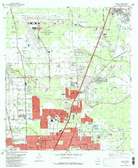 1982 Humble1982 Print · USGSNorth of Houston in the early eighties, the landscape is defined by the growth of modern aviation and expanding suburbs. Researchers can trace family roots through numerous sites like Brookside Memorial Park (Cem), Bordersville, and Mac Arthur High Sch.
 - 1982 Map of Harmaston
 1982 Harmaston1982 Print · USGSNortheast of Houston in the early 1980s, this area balances burgeoning residential developments with vital water and energy infrastructure. Genealogists and historians can trace the Old Pacific Railroad Grade, locate the Harrington Cem, and see the extent of the Riverside Oil Field.
End of results
Showing maps 1-2 of 2
Top cities near Fall Creek
- Houston historical maps
- Pasadena historical maps
- The Woodlands historical maps
- Atascocita historical maps
- Kingwood historical maps
- Baytown historical maps
See more
Top neighborhoods of Fall Creek
- Autumn Falls historical maps
- Fall Creek historical maps
- Heather Glen historical maps
- Lake Point historical maps
- Magnolia Falls historical maps
- Serrano Creek historical maps
See more
Frequently asked questions
- What are the different types of historical maps available for Fall Creek?
- What is the oldest map of Fall Creek?
- Where can I purchase historical maps of Fall Creek for my home or office?
- Where can I download high-res historical maps of Fall Creek?
- Are there historical topographic maps available for Fall Creek?
- Is there historical aerial imagery available for Fall Creek?
- Where are historical maps of Fall Creek sourced from?