1960s Maps of Hays County, Texas
Explore 21 historic maps of Hays County from the 1960s. These maps offer a rare glimpse into what life looked like during the 1960s — showing old roads, neighborhoods, homes, and landmarks that have changed or disappeared over time.
Whether you're researching your family's past, planning a metal detecting trip, or studying how Hays County's landscape evolved across the 1960s, these high-resolution maps are a powerful tool for exploring the history of this region.
- Focus on a specific era: All maps on this page are from the 1960s, giving you a focused view of this time period.
- See what’s changed: Compare century-old streets, trails, and buildings to today's modern landscape using overlays and satellite layers.
- Research with precision: Use these maps for genealogy, historical research, land use analysis, or educational projects.
- View, download, or print: Maps are fully viewable online in high resolution, and can be downloaded or printed for your own records.
Start exploring Hays County's history through authentic maps from the 1960s. This is your window into the past.
Hays County, TX maps
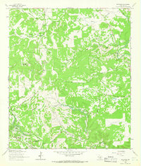
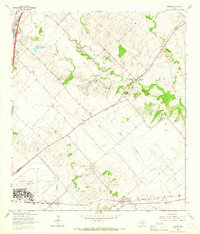
(21)- 1963 Map of Dripping Springs, 1965 Print
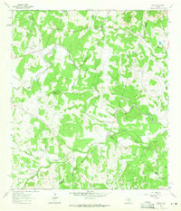
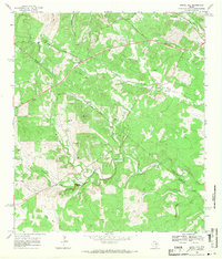
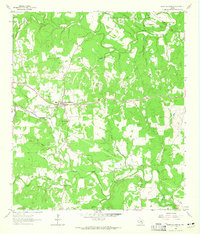 1963 Dripping Springs1965 Print · USGSDripping Springs and the Hays County backcountry are captured in the early sixties as a region of winding creeks and limestone hills. Researchers can trace family history at Fitzhugh Cem and Phillips Cem, or locate landmarks like Camp Ben McCulloch and Walnut Spring.2 unique versions available
 - 1963 Map of Rough Hollow, 1965 Print
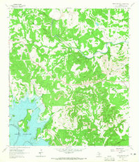
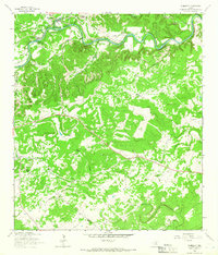
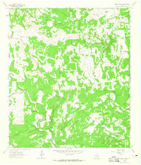 1963 Rough Hollow1965 Print · USGSThe Texas Hill Country comes alive in this early 1960s survey of the Blanco River valley. Trace family history at Mt Sharp Cem or locate the artesian flow of Jacobs Well (Flowing) and the historic Pleasant Valley Crossing.3 unique versions available
 - 1963 Map of Yeager Creek, 1965 Print
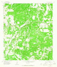 1963 Yeager Creek1965 Print · USGSBlanco County in the early sixties is shown here as a landscape of interconnected ranchlands and winding waterways. Researchers can trace historical property boundaries along Miller Creek, Yeager Creek, and the headwaters of Onion Creek.2 unique versions available
 - 1963 Map of Henly, 1965 Print
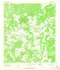 1963 Henly1965 Print · USGSHays County during the early sixties is captured here as a landscape of small family cemeteries and winding creek branches. Genealogists can locate several family plots including Middlebrooks Cem and Moore Cem near the community of Henly.4 unique versions available
 - 1963 Map of Payton, 1965 Print
 1963 Payton1965 Print · USGSIn the early sixties, the Texas Hill Country around the Blanco River remained a landscape of quiet rural communities and perennial springs. Researchers can trace the civic heart of Payton through its Payton Sch, Payton Cem, and the unique topography of The Narrows.3 unique versions available
 - 1963 Map of Devils Backbone, 1965 Print
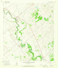
 1963 Devils Backbone1965 Print · USGSThe Comal and Hays county line near the Guadalupe River is shown here in the early sixties, just as the basin began filling. Researchers can locate family landmarks like Valley Ford Cemetery, El Rancho Cima, and the ridge road along the Devils Backbone.3 unique versions available
 - 1963 Map of Lockhart North, 1966 Print
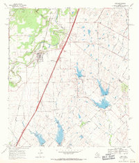
 1963 Lockhart North1966 Print · USGSCaldwell County's landscape in the early sixties showcases a growing Lockhart integrated with a sophisticated network of flood control reservoirs and rail lines. Family historians can trace rural roots through Ohlendorf Cem, Polonia Cem, and the Carver High Sch.3 unique versions available
 - 1964 Map of Hunter, 1965 Print
 1964 Hunter1965 Print · USGSMid-century Comal County is characterized by a dense network of family cemeteries and dual-rail transit through the settlement of Hunter. Researchers can locate historic rural burial grounds like Rosenthal Cem and trace the paths of the Missouri Pacific and Missouri Kansas Texas lines.5 unique versions available
 - 1964 Map of Martindale, 1966 Print
 1964 Martindale1966 Print · USGSThe river-bottom lands of Caldwell and Guadalupe counties come alive in the mid-1960s as the San Marcos River winds past rural farmsteads. Researchers can trace family history through a dense network of local burial sites including Martindale Cem, Staples Cem, and Kennedy Cem.3 unique versions available
 - 1964 Map of San Marcos South, 1966 Print
 1964 San Marcos South1966 Print · USGSThe rural hills south of San Marcos were defined by a junction of major railroads and creek-fed farms in the mid-1960s. Researchers can trace family history through sites like Pitts Cemetery or locate old school sites like Bowie School near Centerpoint.3 unique versions available
 - 1964 Map of Driftwood, 1966 Print
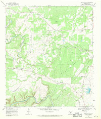
 1964 Driftwood1966 Print · USGSThe hills of Hays County are captured here in the mid-1960s, showing the early character of Wimberley and the rural roads near Driftwood. Genealogists and local researchers can trace family ranch lands like Storm Ranch and landmarks like Joe Wimberley Mountain.3 unique versions available
 - 1964 Map of Wimberley, 1966 Print
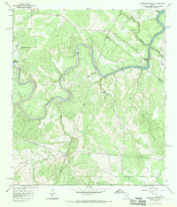
 1964 Wimberley1966 Print · USGSThe Wimberley area of the Texas Hill Country comes into focus during the mid-1960s, showing a landscape defined by the Blanco River and ranching heritage. Researchers can trace family-named lands like Freeman Ranch and Scrutchin Ranch or locate the early layout of Pioneer Town.2 unique versions available
 - 1964 Map of Uhland, 1966 Print
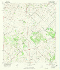
 1964 Uhland1966 Print · USGSThe Blackland Prairie of Hays and Caldwell Counties comes into focus during the mid-1960s, a time when small agricultural hubs still dominated the landscape. You can trace family roots through localized sites like Doyle Cem, San Juan Ch, and the rail-side community of Maxwell.3 unique versions available
 - 1964 Map of San Marcos North, 1966 Print
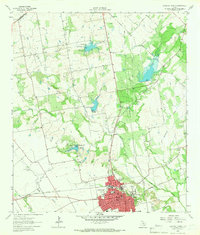
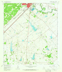
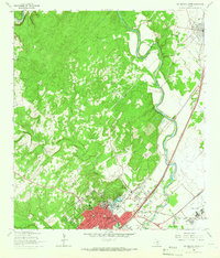 1964 San Marcos North1966 Print · USGSThe hill country transition near San Marcos and Kyle is documented here in the mid-1960s, showing the intersection of river, rail, and university life. Researchers can trace the grounds of Southwest Texas State College or find family sites at Kyle Cem and Guadalupe Cem.5 unique versions available
 - 1966 Map of Oak Hill, 1969 Print
 1966 Oak Hill1969 Print · USGSSouthwest Austin was undergoing a transformation in the late sixties as suburban development reached into Travis County. Researchers can trace early family sites and rural landmarks like Kineheonville, Manchaca, and Williamson Creek Cem.2 unique versions available
 - 1967 Map of Shingle Hills, 1970 Print
 1967 Shingle Hills1970 Print · USGSThe Travis and Hays County line crosses this central Texas landscape in the late sixties, where the hills meet the waters of Lake Travis. Family researchers and local historians can locate the Peryear Cem, the Shield Ranch Landing Strip, and springs like Bell Spring.
 - 1967 Map of Hammetts Crossing, 1970 Print
 1967 Hammetts Crossing1970 Print · USGSTexas Hill Country life centers on the river in the late sixties, where Blanco, Hays, and Travis counties meet. Researchers can trace historic river access at Hammetts Crossing, Dead Mans Ford, and the natural landmark at Hamilton Pool.2 unique versions available
 - 1968 Map of Signal Hill, 1971 Print
 1968 Signal Hill1971 Print · USGSTexas ranching life and early suburban development converge on the Travis and Hays county line during the late sixties. Researchers can trace family landmarks like Cedar Valley, Oliver Cem, and legacy properties such as Signal Hill Ranch.3 unique versions available
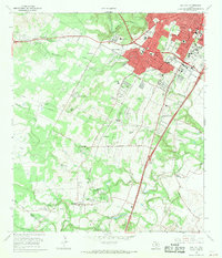
 - 1968 Map of Buda, 1971 Print
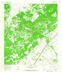
 1968 Buda1971 Print · USGSThe Hays and Travis County borderlands come to life in this late sixties survey of the Buda area. Genealogists and historians can trace family names and early rural centers through sites like Allen Cem, Science Hall, and the Martin Ch.4 unique versions available
 - 1968 Map of Creedmoor, 1971 Print
 1968 Creedmoor1971 Print · USGSCentral Texas farm country comes into focus in the late sixties as Creedmoor and Niederwald anchor the rural landscape. Trace family roots through local landmarks like Vasquez Cem, Creedmoor Cem, and the Center Union Ch.4 unique versions available
 - 1968 Map of Mountain City, 1971 Print
 1968 Mountain City1971 Print · USGSTexas Hill Country ranching life is well-documented here in the late sixties, showing the vast estates and rural outposts south of Austin. Researchers can trace family legacies at Kuykendall Ranch, Ruby Ranch, and the Barton Cem near the banks of Onion Creek.4 unique versions available
End of results
Showing maps 1-21 of 21
Top cities of Hays County
- San Marcos historical maps
- Kyle historical maps
- Buda historical maps
- Dripping Springs historical maps
- Wimberley historical maps
- Woodcreek historical maps
See more
Frequently asked questions
- What are the different types of historical maps available for Hays County?
- What is the oldest map of Hays County?
- Where can I purchase historical maps of Hays County for my home or office?
- Where can I download high-res historical maps of Hays County?
- Are there historical topographic maps available for Hays County?
- Is there historical aerial imagery available for Hays County?
- Where are historical maps of Hays County sourced from?