1980s Maps of Hunt County, Texas
Explore 9 historic maps of Hunt County from the 1980s. These maps offer a rare glimpse into what life looked like during the 1980s — showing old roads, neighborhoods, homes, and landmarks that have changed or disappeared over time.
Whether you're researching your family's past, planning a metal detecting trip, or studying how Hunt County's landscape evolved across the 1980s, these high-resolution maps are a powerful tool for exploring the history of this region.
- Focus on a specific era: All maps on this page are from the 1980s, giving you a focused view of this time period.
- See what’s changed: Compare century-old streets, trails, and buildings to today's modern landscape using overlays and satellite layers.
- Research with precision: Use these maps for genealogy, historical research, land use analysis, or educational projects.
- View, download, or print: Maps are fully viewable online in high resolution, and can be downloaded or printed for your own records.
Start exploring Hunt County's history through authentic maps from the 1980s. This is your window into the past.
Hunt County, TX maps
(9)- 1980 Map of Poetry
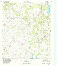 1980 Poetry1980 Print · USGSThe rural Texas landscape at the transition of the seventies and eighties reveals a network of water and energy infrastructure. Genealogists can locate several family and community landmarks, including Henderson-Mosley Cem, Campground Ch, and the old Poetry settlement.2 unique versions available
 - 1980 Map of West Tawakoni
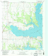 1980 West Tawakoni1980 Print · USGSHunt County and the shores of the great reservoir are captured here during the 1980s, a time of lakeside growth and rural transition. Local researchers can trace family landmarks like Mc Bride Cem or explore the development of West Tawakoni and the grounds of the Boles Home.2 unique versions available
 - 1980 Map of Emory North
 1980 Emory North1980 Print · USGSEast Texas at the turn of the 1980s reveals a landscape defined by its waterways and tight-knit rural communities. Genealogists can trace family heritage through numerous landmarks like Hill-Pippin Cem, County Line Ch, and the growing Lake Fork Reservoir.
 - 1980 Map of Iron Bridge Dam
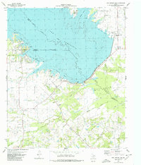 1980 Iron Bridge Dam1980 Print · USGSThe shorelines of Van Zandt and Hunt Counties are captured here as they appeared in the early eighties, centered on the massive Iron Bridge Dam. Genealogists and local historians can locate Bright Star Ch, Shook Cem, and the old settlement of Flats.
 - 1984 Map of Tyler
 1984 Tyler1984 Print · USGSEast Texas at the peak of its reservoir-building era shows a landscape defined by new lakes and established rail corridors. Trace the path of the St Louis Southwestern RR or locate industrial sites like the Longhorn Ordnance Works.3 unique versions available
 - 1985 Map of McKinney
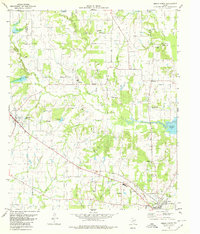
 1985 McKinney1985 Print · USGSNorth Texas in the mid-1980s was a landscape of rural communities connected by a complex web of railroads and creek systems. Researchers can trace family roots through settlements like Westminster, find local landmarks like Henslee Chapel, or map the industrial activity at various Gravel Pits.2 unique versions available
 - 1985 Map of Mineola
 1985 Mineola1985 Print · USGSUpper East Texas in the mid-eighties shows a region shaped by the Sabine River and large-scale water projects. Researchers can trace the rail heritage of the Missouri Pacific RR and locate rural landmarks like Ambassador College Res or the Oil Field.
 - 1985 Map of Sulphur Springs
 1985 Sulphur Springs1985 Print · USGSNortheast Texas in the mid-eighties shows a landscape transitioning between its deep-rooted rail towns and a new era of reservoir development. Genealogists and historians can trace family locations near Shooks Chapel, the rural Farmers Academy, and the banks of the South Sulphur River.
 - 1986 Map of Dallas
 1986 Dallas1986 Print · USGSThe North Texas metropolitan landscape comes into focus during the mid-eighties as urban growth expands toward the eastern reservoirs. Researchers can trace historic cemeteries like Oak Cliff Cem, rail corridors of the Texas & Pacific RR, and landmarks such as Southern Methodist University.3 unique versions available
End of results
Showing maps 1-9 of 9
Top cities of Hunt County
- Greenville historical maps
- Commerce historical maps
- Caddo Mills historical maps
- West Tawakoni historical maps
- West Tawakoni historical maps
- Quinlan historical maps
See more
Frequently asked questions
- What are the different types of historical maps available for Hunt County?
- What is the oldest map of Hunt County?
- Where can I purchase historical maps of Hunt County for my home or office?
- Where can I download high-res historical maps of Hunt County?
- Are there historical topographic maps available for Hunt County?
- Is there historical aerial imagery available for Hunt County?
- Where are historical maps of Hunt County sourced from?