Old Maps of Hunt County, Texas for Academic Research
Study the evolution of Hunt County with 179 high-resolution historic maps. Whether you're teaching, researching, or modeling changes in land use, these maps provide essential visual documentation of urban, environmental, and geographic change.
- Analyze long-term change: Track patterns in development, transportation, and natural features.
- Ideal for environmental or urban studies: Support academic projects with primary historical map data.
- Use in the classroom or lab: Educators and researchers rely on these maps to bring historical context to life.
These maps are a powerful tool for teaching, research, and visualizing how Hunt County has changed over the decades.
Hunt County, TX maps
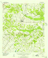
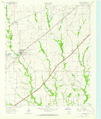
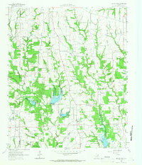
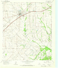
(179)- 1919 Map of Royse City
 1919 Royse City1919 Print · USGSThe agricultural heart of Northeast Texas is captured here just after the Great War, as the Blackland Prairie was crisscrossed by essential rail lines. Trace the locations of early rural landmarks like Locust Grove School, the Randle Ranch, and the vanished stop at Rockwall Station.
 - 1930 Map of Farmersville
 1930 Farmersville1930 Print · USGSSoutheastern Collin County in the early twentieth century shows a landscape of rail-connected towns and rural school districts. Genealogists can locate family landmarks like Stringtown, Cairo Sch, and BUMPASS BRIDGE along the East Fork Trinity River.2 unique versions available
 - 1953 Map of Texarkana, 1964 Print
 1953 Texarkana1964 Print · USGSThe Texas-Arkansas borderlands are captured here in the mid-fifties, during a decade of massive military and hydraulic engineering projects. Genealogists and researchers can locate family landmarks like Old Boston Cem, Siloam Ch, and the vast Red River Arsenal.4 unique versions available
 - 1954 Map of Dallas, 1963 Print
 1954 Dallas1963 Print · USGSNorth Texas in the mid-fifties and early sixties reveals a landscape of rapid urban growth and water management. Genealogists and historians can trace the evolution of the metroplex through landmarks like Hensley Field, Boles Orphan Home, and the Texas & Pacific RR.4 unique versions available
 - 1954 Map of Sherman, 1964 Print
 1954 Sherman1964 Print · USGSThe Red River valley and North Texas plains are captured here in the mid-fifties, showing the region as new reservoirs like Lake Texoma and Lavon Reservoir reshaped the land. Genealogists can trace family roots through specific local landmarks like Courtney P O, Pilot Grove Sch, and New Hope Ch.2 unique versions available
 - 1956 Map of Texarkana
 1956 Texarkana1956 Print · USGSThe Ark-La-Tex borderlands come alive in the mid-fifties, showing the transition from a rail-dependent rural economy to a post-war industrial landscape. Researchers can trace the massive Red River Ordnance Depot and find towns like Talco, Bogata, and Naples.
 - 1956 Map of Tyler
 1956 Tyler1956 Print · USGSEast Texas was a powerhouse of oil production and rail transport during the mid-fifties, centered on the sprawling East Texas Oil Field. Researchers can trace the heritage of industrial hubs like Kilgore, military sites such as the Longhorn Ordnance Works, and many rural landmarks like Mount Enterprise.5 unique versions available
 - 1956 Map of Quinlan, 1957 Print
 1956 Quinlan1957 Print · USGSNortheast Texas at the height of the post-war era is depicted here through its network of small crossroads communities and family farms. Researchers can trace rural lineages through local landmarks like Union Valley Sch, the Boys Home (Orphanage), and the Masonic Cem near Quinlan.3 unique versions available
 - 1956 Map of Emory, 1957 Print
 1956 Emory1957 Print · USGSRains County and its neighbors are shown here in the mid-fifties, just as the Sabine River valley prepared for the construction of the Iron Bridge Damsite. Genealogists can trace family roots through numerous small landmarks like Bright Star Ch, Cody Sch, and Parks Cem.3 unique versions available
 - 1958 Map of Dallas
 1958 Dallas1958 Print · USGSNorth Texas in the late fifties shows the dramatic expansion of the Metroplex as it absorbs surrounding farm towns. Genealogists and historians can trace old rail lines like the Missouri-Kansas-Texas and locate early lakefront developments at Eagle Mountain Lake and Lake Worth Village.
 - 1958 Map of Sherman, 1959 Print
 1958 Sherman1959 Print · USGSNorth Texas and Southern Oklahoma were undergoing significant development in the late fifties as the Red River Valley transit networks matured. Researchers can trace historic family-named locations such as Saddler Bend, the grounds of Perrin AFB, and early shoreline developments at Lake Texoma.
 - 1960 Map of Pike, 1962 Print
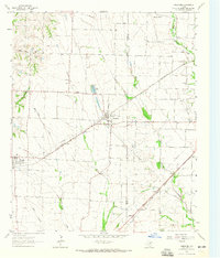
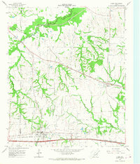
 1960 Pike1962 Print · USGSNortheast Texas at the start of the sixties is a landscape of quiet rural junctions and family homesteads where Collin, Fannin, and Hunt counties meet. Genealogists can trace early settler footprints at Indian Creek Cem, Fuller Cem, and the small settlement of Frognot.2 unique versions available
 - 1962 Map of Greenville NW, 1964 Print
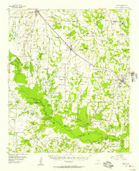
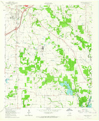
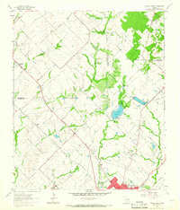
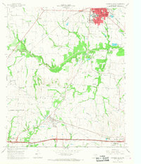
 1962 Greenville NW1964 Print · USGSHunt County, Texas, was a crossroads of the rail industry in the early sixties, defined by three major intersecting lines. Genealogists can trace family roots through the Barnett Boles Cem, McWright Cem, and rural centers like Floyd and Kingston.2 unique versions available
 - 1962 Map of Greenville SW, 1964 Print
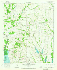
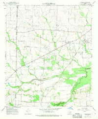
 1962 Greenville SW1964 Print · USGSHunt County, Texas, was a landscape of rail-driven towns and small agricultural communities in the early sixties. Genealogists can trace family footprints at the IOOF Cem, Paradise Ch, and the rural crossroads of Clinton or Hendrix.
 - 1962 Map of Greenville SE, 1964 Print
 1962 Greenville SE1964 Print · USGSIn the early sixties, the area southeast of Greenville was a landscape of aviation, oil exploration, and rural family settlements. Researchers can trace landownership through landmarks like Majors Field, Weiland Oil Field, and several country churches including Rattle Ax Ch.
 - 1962 Map of Farmersville, 1965 Print
 1962 Farmersville1965 Print · USGSFarmersville and the surrounding Collin County prairie are captured here in the early sixties as a thriving rail and agricultural center. Researchers can locate vanished rural landmarks and family sites like Welford Sch, Merit Cem, and the Highmound Park Training Track.3 unique versions available
 - 1962 Map of Lone Oak North, 1965 Print
 1962 Lone Oak North1965 Print · USGSHunt County at the start of the 1960s shows a landscape of traditional rural communities meeting new water infrastructure. Researchers can locate family roots at Sullivan Cem or Twin Oak Cem and trace the Old Railroad Grade through Lone Oak.
 - 1962 Map of Miller Grove, 1966 Print
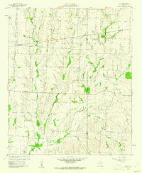
 1962 Miller Grove1966 Print · USGSCrossing the Hopkins and Hunt county line in the early sixties, this area shows a landscape of rural crossroads and creek-side settlements. Genealogists can trace early families at Donelton Cem, Liberty Point Cem, and the rural Donelton Ch.2 unique versions available
 - 1962 Map of Terrell North, 1966 Print
 1962 Terrell North1966 Print · USGSKaufman County in the early sixties reveals a landscape of small farming communities and the steady growth of Terrell. Trace historical footprints at Chisholm and Colquitt, or follow the Texas and Pacific Railroad line.
 - 1963 Map of Greenville NE, 1964 Print
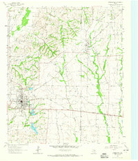
 1963 Greenville NE1964 Print · USGSHunt County in the early sixties is captured here as a critical rail hub where three major lines meet. Researchers can trace family history through sites like Old Concord Ch, Hopkins No 1 Cem, and the community of Neylandville.3 unique versions available
 - 1963 Map of Josephine, 1965 Print
 1963 Josephine1965 Print · USGSNortheastern Texas farmland near the Collin and Hunt County line is captured in the early sixties, showing a landscape defined by rail and creek. Trace local family history at the Josephine Cem, Needmore Cem, or the old Community Sch.2 unique versions available
 - 1963 Map of Royse City, 1966 Print
 1963 Royse City1966 Print · USGSThe Blackland Prairies of Rockwall and Collin counties are seen here in the early sixties as rural life began to meet modern infrastructure. Genealogists can trace early family sites like Zollner Ranch or locate burials at Blackland Cem and the village Cemetery near Royse City.2 unique versions available
 - 1964 Map of Cumby, 1968 Print
 1964 Cumby1968 Print · USGSThe rural landscape of Hopkins and Hunt Counties in the 1960s is defined by its rail-and-river network before major landscape changes. Genealogists can trace family landmarks like Oakland Cem and small settlements such as Ridgeway and Branom.2 unique versions available
 - 1964 Map of Commerce South, 1968 Print
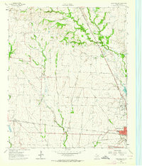
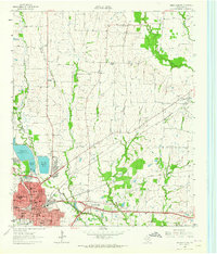
 1964 Commerce South1968 Print · USGSThe hunt for family roots and rural Texas history in the mid-sixties leads through Commerce and the South Sulphur River valley. Trace the old rail lines and find landmarks like East Texas State College, the Rodeo Ground, and numerous family burial sites like Brigham Cem.
 - 1964 Map of Klondike, 1968 Print
 1964 Klondike1968 Print · USGSDelta County agricultural life is captured here in the mid-sixties, showing a landscape defined by the Southern Pacific rail line and the Sulphur River forks. Genealogists can locate family landmarks like Shiloh Cem, Wintermute Mem Hosp, and the community of Klondike.2 unique versions available
Showing maps 1-25 of 179
Top cities of Hunt County
- Greenville historical maps
- Commerce historical maps
- Caddo Mills historical maps
- West Tawakoni historical maps
- West Tawakoni historical maps
- Quinlan historical maps
See more
Frequently asked questions
- What are the different types of historical maps available for Hunt County?
- What is the oldest map of Hunt County?
- Where can I purchase historical maps of Hunt County for my home or office?
- Where can I download high-res historical maps of Hunt County?
- Are there historical topographic maps available for Hunt County?
- Is there historical aerial imagery available for Hunt County?
- Where are historical maps of Hunt County sourced from?