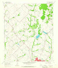
1962 Map of Terrell North
USGS Topo · Published 1966About this map
The northwest reaches of Terrell and the surrounding Kaufman County countryside appear here as they were transitioning in the early 1960s. The southern edge of the sheet is dominated by the Texas and Pacific Railroad and the expanding residential footprint of the city, including the Oak Grove Country Club and Forest Lawn Cem. Moving north, the landscape remains primarily agricultural, dotted with small rural communities and family-named landmarks like Chisholm, Lawrence, and Colquitt.
Find a feature on this map
33 named features on this map. Tap any name to fly to it.
Don’t see what you’re looking for? This feature index may not catch every label — zoom into the map to look around manually.
Map Details
Editions of this 1962 Terrell North Map
This is the sole edition of this map. No revisions or reprints were ever made.
Other maps of this area

1912 · Rockwall
USGS Topo · 1:31,680

1919 · Royse City
USGS Topo · 1:62,500

1954 · Dallas
USGS Topo · 1:250,000

1956 · Kaufman
USGS Topo · 1:62,500

1956 · Quinlan
USGS Topo · 1:62,500

1958 · Dallas
USGS Topo · 1:250,000

1962 · Elmo
USGS Topo · 1:24,000
1963 · Forney South
USGS Topo · 1:24,000
1963 · Terrell South
USGS Topo · 1:24,000
1963 · Forney North
USGS Topo · 1:24,000