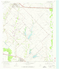
1963 Map of Forney South
USGS Topo · Published 1963About this map
Crandall and Forney anchor the rural landscape of Kaufman County in the early 1960s, a period marked by the development of water management structures along the East Fork Trinity River floodplain. The map documents the early stages of local reservoir planning through labeled lateral sites, such as Lower East Fork Lateral Site No 1 and Lateral Site No 2. These flood control measures intersect an older network of farm-to-market roads and historic family landmarks including Irish Ridge and the Blackland Cem.
Find a feature on this map
30 named features on this map. Tap any name to fly to it.
Don’t see what you’re looking for? This feature index may not catch every label — zoom into the map to look around manually.
Map Details
Editions of this 1963 Forney South Map
Other maps of this area

1891 · Dallas
USGS Topo · 1:125,000

1893 · Dallas
USGS Topo · 1:125,000

1919 · Royse City
USGS Topo · 1:62,500

1954 · Dallas
USGS Topo · 1:250,000

1956 · Kaufman
USGS Topo · 1:62,500

1958 · Dallas
USGS Topo · 1:250,000

1959 · Mesquite
USGS Topo · 1:24,000

1959 · Seagoville
USGS Topo · 1:24,000

1959 · India
USGS Topo · 1:24,000

1959 · Seagoville
USGS Topo · 1:62,500