
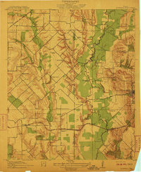
1919 Map of Royse City
USGS Topo · Published 1919About this map
Royse City and the surrounding prairie of Rockwall County appear here during a period of steady agrarian development at the edge of the East Fork of Trinity River. The landscape is defined by a dense network of early thoroughfares such as Valley View Pike and Colquitt Road, connecting numerous small community anchors. Researchers will find a high concentration of local educational landmarks, including Locust Grove School, Glen Hill School, and the uniquely named Lone Pecan School near Kruger.
Find a feature on this map
65 named features on this map. Tap any name to fly to it.
Don’t see what you’re looking for? This feature index may not catch every label — zoom into the map to look around manually.
Map Details
Editions of this 1919 Royse City Map
This is the sole edition of this map. No revisions or reprints were ever made.
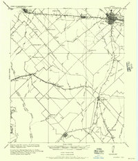
Other maps of this area

1891 · Dallas
USGS Topo · 1:125,000

1893 · Dallas
USGS Topo · 1:125,000
1912 · Rockwall
USGS Topo · 1:31,680

1924 · Farmersville 3-c
USGS Topo · 1:48,000

1924 · Mc Kinney 4-d
USGS Topo · 1:48,000

1929 · McKinney
USGS Topo · 1:62,500

1930 · Farmersville
USGS Topo · 1:62,500

1954 · Dallas
USGS Topo · 1:250,000

1954 · Sherman
USGS Topo · 1:250,000
1956 · Kaufman
USGS Topo · 1:62,500