
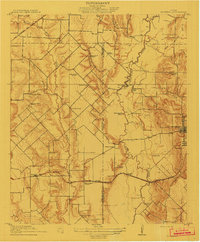
1912 Map of Rockwall
USGS Topo · Published 1912About this map
Rockwall anchors this 1909 survey, appearing as a compact settlement at the edge of the Bois D'Arc River bottomlands before the mid-century creation of major reservoirs. The landscape is defined by the sinuous path of the river and its many tributaries, including Muddy Creek and Rowlett Creek, which dictated the placement of early crossings like Wells Bridge. A dense network of rural infrastructure reveals the decentralized nature of early 20th-century life, with numerous independent schools such as Cottonwood School, Collin School, and Davis School serving isolated farmsteads. Two major rail lines, the Gulf Colorado and Santa Fe RR and the Missouri Kansas and Texas RR, bisect the area, providing the vital link between agricultural communities like Cheisa and Rowlett and the larger regional markets. Small landmarks like Lewis Store and Wards Chapel highlight the community centers of the era.
Find a feature on this map
44 named features on this map. Tap any name to fly to it.
Don’t see what you’re looking for? This feature index may not catch every label — zoom into the map to look around manually.
Map Details
Editions of this 1912 Rockwall Map
2 editions found
Other maps of this area

1891 · Dallas
USGS Topo · 1:125,000

1893 · Dallas
USGS Topo · 1:125,000

1919 · Royse City
USGS Topo · 1:62,500

1924 · Farmersville 3-c
USGS Topo · 1:48,000

1924 · Mc Kinney 4-d
USGS Topo · 1:48,000

1929 · McKinney
USGS Topo · 1:62,500

1930 · Farmersville
USGS Topo · 1:62,500

1954 · Dallas
USGS Topo · 1:250,000

1954 · Sherman
USGS Topo · 1:250,000

1958 · Dallas
USGS Topo · 1:250,000