1960s Maps of Hunt County, Texas
Explore 20 historic maps of Hunt County from the 1960s. These maps offer a rare glimpse into what life looked like during the 1960s — showing old roads, neighborhoods, homes, and landmarks that have changed or disappeared over time.
Whether you're researching your family's past, planning a metal detecting trip, or studying how Hunt County's landscape evolved across the 1960s, these high-resolution maps are a powerful tool for exploring the history of this region.
- Focus on a specific era: All maps on this page are from the 1960s, giving you a focused view of this time period.
- See what’s changed: Compare century-old streets, trails, and buildings to today's modern landscape using overlays and satellite layers.
- Research with precision: Use these maps for genealogy, historical research, land use analysis, or educational projects.
- View, download, or print: Maps are fully viewable online in high resolution, and can be downloaded or printed for your own records.
Start exploring Hunt County's history through authentic maps from the 1960s. This is your window into the past.
Hunt County, TX maps
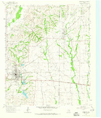
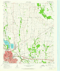
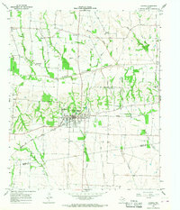
(20)- 1960 Map of Pike, 1962 Print
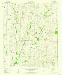 1960 Pike1962 Print · USGSNortheast Texas at the start of the sixties is a landscape of quiet rural junctions and family homesteads where Collin, Fannin, and Hunt counties meet. Genealogists can trace early settler footprints at Indian Creek Cem, Fuller Cem, and the small settlement of Frognot.2 unique versions available
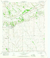
 - 1962 Map of Greenville NW, 1964 Print
 1962 Greenville NW1964 Print · USGSHunt County, Texas, was a crossroads of the rail industry in the early sixties, defined by three major intersecting lines. Genealogists can trace family roots through the Barnett Boles Cem, McWright Cem, and rural centers like Floyd and Kingston.2 unique versions available
 - 1962 Map of Greenville SW, 1964 Print
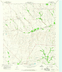
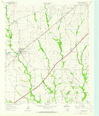 1962 Greenville SW1964 Print · USGSHunt County, Texas, was a landscape of rail-driven towns and small agricultural communities in the early sixties. Genealogists can trace family footprints at the IOOF Cem, Paradise Ch, and the rural crossroads of Clinton or Hendrix.
 - 1962 Map of Greenville SE, 1964 Print
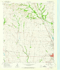
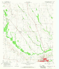
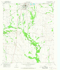
 1962 Greenville SE1964 Print · USGSIn the early sixties, the area southeast of Greenville was a landscape of aviation, oil exploration, and rural family settlements. Researchers can trace landownership through landmarks like Majors Field, Weiland Oil Field, and several country churches including Rattle Ax Ch.
 - 1962 Map of Farmersville, 1965 Print
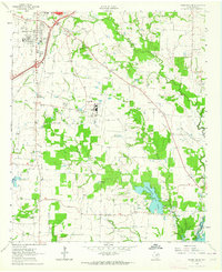
 1962 Farmersville1965 Print · USGSFarmersville and the surrounding Collin County prairie are captured here in the early sixties as a thriving rail and agricultural center. Researchers can locate vanished rural landmarks and family sites like Welford Sch, Merit Cem, and the Highmound Park Training Track.3 unique versions available
 - 1962 Map of Lone Oak North, 1965 Print
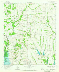 1962 Lone Oak North1965 Print · USGSHunt County at the start of the 1960s shows a landscape of traditional rural communities meeting new water infrastructure. Researchers can locate family roots at Sullivan Cem or Twin Oak Cem and trace the Old Railroad Grade through Lone Oak.
 - 1962 Map of Miller Grove, 1966 Print
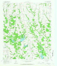 1962 Miller Grove1966 Print · USGSCrossing the Hopkins and Hunt county line in the early sixties, this area shows a landscape of rural crossroads and creek-side settlements. Genealogists can trace early families at Donelton Cem, Liberty Point Cem, and the rural Donelton Ch.2 unique versions available
 - 1962 Map of Terrell North, 1966 Print
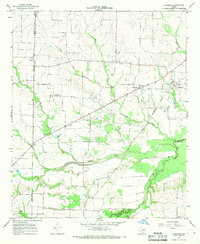
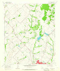 1962 Terrell North1966 Print · USGSKaufman County in the early sixties reveals a landscape of small farming communities and the steady growth of Terrell. Trace historical footprints at Chisholm and Colquitt, or follow the Texas and Pacific Railroad line.
 - 1963 Map of Greenville NE, 1964 Print
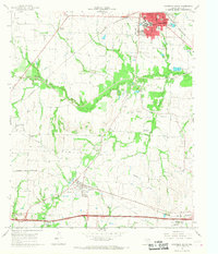
 1963 Greenville NE1964 Print · USGSHunt County in the early sixties is captured here as a critical rail hub where three major lines meet. Researchers can trace family history through sites like Old Concord Ch, Hopkins No 1 Cem, and the community of Neylandville.3 unique versions available
 - 1963 Map of Josephine, 1965 Print
 1963 Josephine1965 Print · USGSNortheastern Texas farmland near the Collin and Hunt County line is captured in the early sixties, showing a landscape defined by rail and creek. Trace local family history at the Josephine Cem, Needmore Cem, or the old Community Sch.2 unique versions available
 - 1963 Map of Royse City, 1966 Print
 1963 Royse City1966 Print · USGSThe Blackland Prairies of Rockwall and Collin counties are seen here in the early sixties as rural life began to meet modern infrastructure. Genealogists can trace early family sites like Zollner Ranch or locate burials at Blackland Cem and the village Cemetery near Royse City.2 unique versions available
 - 1964 Map of Cumby, 1968 Print
 1964 Cumby1968 Print · USGSThe rural landscape of Hopkins and Hunt Counties in the 1960s is defined by its rail-and-river network before major landscape changes. Genealogists can trace family landmarks like Oakland Cem and small settlements such as Ridgeway and Branom.2 unique versions available
 - 1964 Map of Commerce South, 1968 Print
 1964 Commerce South1968 Print · USGSThe hunt for family roots and rural Texas history in the mid-sixties leads through Commerce and the South Sulphur River valley. Trace the old rail lines and find landmarks like East Texas State College, the Rodeo Ground, and numerous family burial sites like Brigham Cem.
 - 1964 Map of Klondike, 1968 Print
 1964 Klondike1968 Print · USGSDelta County agricultural life is captured here in the mid-sixties, showing a landscape defined by the Southern Pacific rail line and the Sulphur River forks. Genealogists can locate family landmarks like Shiloh Cem, Wintermute Mem Hosp, and the community of Klondike.2 unique versions available
 - 1964 Map of Commerce North, 1968 Print
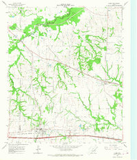
 1964 Commerce North1968 Print · USGSHunt County in the mid-1960s shows a landscape of rail-connected towns and meandering creeks before further modern expansion. Family historians can locate rural landmarks like Hope Cem, Fairlie, and the junction of the Southern Pacific and Cotton Belt railroads.
 - 1964 Map of Celeste, 1968 Print
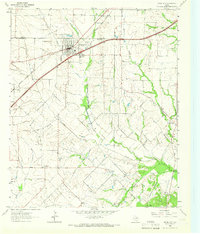
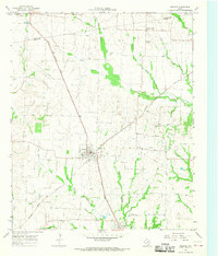 1964 Celeste1968 Print · USGSHunt County at the height of the mid-century rail era reveals a landscape shaped by competing locomotives and winding river forks. Genealogists and local historians can trace family ties through Nicholson Cemetery and Kingston Cemetery or locate old settlements like Hogeye and Lester.
 - 1964 Map of Ladonia, 1968 Print
 1964 Ladonia1968 Print · USGSNortheastern Texas crossroads near the Fannin and Hunt County line are captured here in the mid-sixties. Researchers can trace the Atchison Topeka and Santa Fe rail line and locate rural landmarks like Bug Tussle, Clark High Sch, and the Odd Fellows Cem.
 - 1964 Map of Pecan Gap, 1968 Print
 1964 Pecan Gap1968 Print · USGSPecan Gap and its surrounding farm country appear here in the mid-sixties, dominated by the winding Sulphur River. Genealogists can trace family sites via the many local burial grounds like Bledsoe Cem or the oddly named Jot Em Down community.2 unique versions available
 - 1964 Map of Gober, 1968 Print
 1964 Gober1968 Print · USGSNortheast Texas farmland along the Fannin and Hunt county line is captured here in the mid-sixties as rural life centered on small rail-side towns and river bottoms. Researchers can trace family sites at Rehobeth Cem, the community of Gober, and the Atchison Topeka and Santa Fe rail line.
 - 1965 Map of Wolfe City, 1968 Print
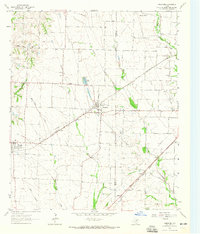
 1965 Wolfe City1968 Print · USGSWolfe City and the rural reaches of Hunt County are captured here in the mid-1960s during a period of agricultural stability. Genealogists and local historians can trace family roots at Westbrook Cem, visit the old Wesley Ch, or follow the Sante Fe and Atchison Topeka rail line.
End of results
Showing maps 1-20 of 20
Top cities of Hunt County
- Greenville historical maps
- Commerce historical maps
- Caddo Mills historical maps
- West Tawakoni historical maps
- West Tawakoni historical maps
- Quinlan historical maps
See more
Frequently asked questions
- What are the different types of historical maps available for Hunt County?
- What is the oldest map of Hunt County?
- Where can I purchase historical maps of Hunt County for my home or office?
- Where can I download high-res historical maps of Hunt County?
- Are there historical topographic maps available for Hunt County?
- Is there historical aerial imagery available for Hunt County?
- Where are historical maps of Hunt County sourced from?