1960s Maps of Caddo Mills, Texas
Explore 2 historic maps of Caddo Mills from the 1960s. These maps offer a rare glimpse into what life looked like during the 1960s — showing old roads, neighborhoods, homes, and landmarks that have changed or disappeared over time.
Whether you're researching your family's past, planning a metal detecting trip, or studying how Caddo Mills's landscape evolved across the 1960s, these high-resolution maps are a powerful tool for exploring the history of this region.
- Focus on a specific era: All maps on this page are from the 1960s, giving you a focused view of this time period.
- See what’s changed: Compare century-old streets, trails, and buildings to today's modern landscape using overlays and satellite layers.
- Research with precision: Use these maps for genealogy, historical research, land use analysis, or educational projects.
- View, download, or print: Maps are fully viewable online in high resolution, and can be downloaded or printed for your own records.
Start exploring Caddo Mills's history through authentic maps from the 1960s. This is your window into the past.
Caddo Mills, TX maps
(2)- 1962 Map of Greenville SW, 1964 Print
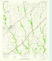 1962 Greenville SW1964 Print · USGSHunt County, Texas, was a landscape of rail-driven towns and small agricultural communities in the early sixties. Genealogists can trace family footprints at the IOOF Cem, Paradise Ch, and the rural crossroads of Clinton or Hendrix.
 - 1963 Map of Josephine, 1965 Print
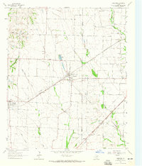 1963 Josephine1965 Print · USGSNortheastern Texas farmland near the Collin and Hunt County line is captured in the early sixties, showing a landscape defined by rail and creek. Trace local family history at the Josephine Cem, Needmore Cem, or the old Community Sch.2 unique versions available
End of results
Showing maps 1-2 of 2
Top cities near Caddo Mills
- Mesquite historical maps
- Rockwall historical maps
- Wylie historical maps
- Greenville historical maps
- Fate historical maps
- Royse City historical maps
See more
Top neighborhoods of Caddo Mills
Frequently asked questions
- What are the different types of historical maps available for Caddo Mills?
- What is the oldest map of Caddo Mills?
- Where can I purchase historical maps of Caddo Mills for my home or office?
- Where can I download high-res historical maps of Caddo Mills?
- Are there historical topographic maps available for Caddo Mills?
- Is there historical aerial imagery available for Caddo Mills?
- Where are historical maps of Caddo Mills sourced from?