1890s Maps of Rockpile Ranch, Texas
Explore 2 historic maps of Rockpile Ranch from the 1890s. These maps offer a rare glimpse into what life looked like during the 1890s — showing old roads, neighborhoods, homes, and landmarks that have changed or disappeared over time.
Whether you're researching your family's past, planning a metal detecting trip, or studying how Rockpile Ranch's landscape evolved across the 1890s, these high-resolution maps are a powerful tool for exploring the history of this region.
- Focus on a specific era: All maps on this page are from the 1890s, giving you a focused view of this time period.
- See what’s changed: Compare century-old streets, trails, and buildings to today's modern landscape using overlays and satellite layers.
- Research with precision: Use these maps for genealogy, historical research, land use analysis, or educational projects.
- View, download, or print: Maps are fully viewable online in high resolution, and can be downloaded or printed for your own records.
Start exploring Rockpile Ranch's history through authentic maps from the 1890s. This is your window into the past.
Rockpile Ranch, TX maps
(2)- 1894 Map of Valentine, 1959 Print
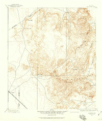 1894 Valentine1959 Print · USGSThe high peaks of West Texas come to life in this late-frontier survey of the Trans-Pecos ranching country. Researchers can trace the early rail influence at Valentine and locate numerous historic homesteads including Hardwicks Ranch and Newmans Ranch.
 - 1897 Map of Valentine
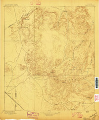 1897 Valentine1897 Print · USGSThe Davis Mountains frontier and the railroad town of Valentine are shown here in the mid-1890s. Researchers can locate remote high-country outposts like Prude's Ranch and Newman's Ranch or trace the early course of the Southern Pacific R. R.6 unique versions available
End of results
Showing maps 1-2 of 2
Top cities near Rockpile Ranch
Frequently asked questions
- What are the different types of historical maps available for Rockpile Ranch?
- What is the oldest map of Rockpile Ranch?
- Where can I purchase historical maps of Rockpile Ranch for my home or office?
- Where can I download high-res historical maps of Rockpile Ranch?
- Are there historical topographic maps available for Rockpile Ranch?
- Is there historical aerial imagery available for Rockpile Ranch?
- Where are historical maps of Rockpile Ranch sourced from?