1940s Maps of Taylor Landing, Texas
Explore 2 historic maps of Taylor Landing from the 1940s. These maps offer a rare glimpse into what life looked like during the 1940s — showing old roads, neighborhoods, homes, and landmarks that have changed or disappeared over time.
Whether you're researching your family's past, planning a metal detecting trip, or studying how Taylor Landing's landscape evolved across the 1940s, these high-resolution maps are a powerful tool for exploring the history of this region.
- Focus on a specific era: All maps on this page are from the 1940s, giving you a focused view of this time period.
- See what’s changed: Compare century-old streets, trails, and buildings to today's modern landscape using overlays and satellite layers.
- Research with precision: Use these maps for genealogy, historical research, land use analysis, or educational projects.
- View, download, or print: Maps are fully viewable online in high resolution, and can be downloaded or printed for your own records.
Start exploring Taylor Landing's history through authentic maps from the 1940s. This is your window into the past.
Taylor Landing, TX maps
(2)- 1943 Map of Fannett East, 1959 Print
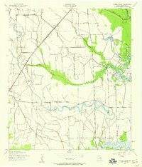 1943 Fannett East1959 Print · USGSJefferson County is mapped during the early 1940s, showing a coastal landscape of bayous and railroads at the height of its mid-century industrial growth. Researchers can trace family history at Broussard Cem or follow the Gulf Colorado and Santa Fe line through Cheek.2 unique versions available
 - 1945 Map of Fannett East
 1945 Fannett East1945 Print · USGSJefferson County coastal prairies and bayous are captured here during the mid-1940s. Researchers can trace local lineage through Broussard Cem, visit the old Fannett School, and map the water-driven economy of Lovell Lake and Bayou Din.
End of results
Showing maps 1-2 of 2
Top cities near Taylor Landing
- Beaumont historical maps
- Port Arthur historical maps
- Nederland historical maps
- Groves historical maps
- Port Neches historical maps
- China historical maps
Frequently asked questions
- What are the different types of historical maps available for Taylor Landing?
- What is the oldest map of Taylor Landing?
- Where can I purchase historical maps of Taylor Landing for my home or office?
- Where can I download high-res historical maps of Taylor Landing?
- Are there historical topographic maps available for Taylor Landing?
- Is there historical aerial imagery available for Taylor Landing?
- Where are historical maps of Taylor Landing sourced from?