1980s Maps of Jones County, Texas
Explore 12 historic maps of Jones County from the 1980s. These maps offer a rare glimpse into what life looked like during the 1980s — showing old roads, neighborhoods, homes, and landmarks that have changed or disappeared over time.
Whether you're researching your family's past, planning a metal detecting trip, or studying how Jones County's landscape evolved across the 1980s, these high-resolution maps are a powerful tool for exploring the history of this region.
- Focus on a specific era: All maps on this page are from the 1980s, giving you a focused view of this time period.
- See what’s changed: Compare century-old streets, trails, and buildings to today's modern landscape using overlays and satellite layers.
- Research with precision: Use these maps for genealogy, historical research, land use analysis, or educational projects.
- View, download, or print: Maps are fully viewable online in high resolution, and can be downloaded or printed for your own records.
Start exploring Jones County's history through authentic maps from the 1980s. This is your window into the past.
Jones County, TX maps
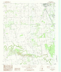
(12)- 1984 Map of Noodle NE
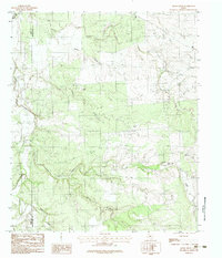
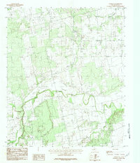 1984 Noodle NE1984 Print · USGSJones County's rural river valleys are captured here in the mid-1980s, documenting a landscape shaped by the Clear Fork Brazos River. Researchers can trace the winding paths of Noodle Creek and Sweetwater Creek to locate historical property boundaries.
 - 1984 Map of Hawley NE
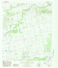
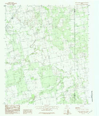
 1984 Hawley NE1984 Print · USGSJones County cattle and energy lands come into focus in the early eighties as utility networks expanded across the Texas plains. Genealogists and researchers can locate the Cem, trace the path of the Aqueduct, and identify the Tank Pumping Station.
 - 1984 Map of Flattop
 1984 Flattop1984 Print · USGSThe rural landscape of the West Texas plains is captured here in the mid-1980s, where three counties meet at the community of Flattop. Genealogists and historians can trace property lines and terrain near Deadman Creek, Spring Creek, and various local Gravel Pits.
 - 1984 Map of Noodle
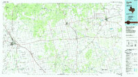
 1984 Noodle1984 Print · USGSThe rural landscape of the Texas Big Country in the late seventies is centered on the settlement of Noodle. Genealogists and historians can trace local infrastructure through the Landing Strip, an Oil Field, and old watercourses like Bitter Creek.
 - 1984 Map of Truby
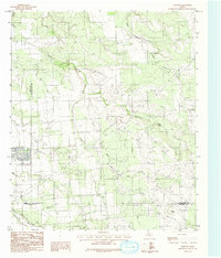
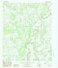
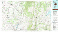
 1984 Truby1984 Print · USGSJones County ranching country and river bottoms are captured here in the early eighties. Genealogists and local historians can trace the course of the Clear Fork Brazos River past the settlement of Truby and the outskirts of Anson.
 - 1984 Map of Stith
 1984 Stith1984 Print · USGSThe rural boundary between Jones and Taylor counties comes into focus in the late 1970s, centered on the community of Stith. Researchers can trace the winding paths of Bitter Creek and Mulberry Creek or locate the local Cem near the settlement.
 - 1984 Map of Nugent
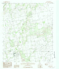
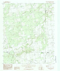
 1984 Nugent1984 Print · USGSJones County ranch lands come into focus during the late seventies, centered on the river-bend settlement of Nugent. Genealogists and historians can trace local landmarks like the Cem, the winding Clear Fork Brazos River, and Deadman Creek.
 - 1984 Map of Raven Creek South
 1984 Raven Creek South1984 Print · USGSFisher County ranchlands meet the borders of Jones, Nolan, and Taylor counties in the mid-1980s. Genealogists and land researchers can trace property locations along Sweetwater Creek, Raven Creek, and the uniquely named Stink Creek.
 - 1984 Map of Smoky Draw
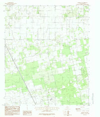
 1984 Smoky Draw1984 Print · USGSThe rural borderlands of Jones and Shackelford counties are captured in the mid-1980s, featuring a landscape shaped by petroleum and ranching. Genealogists and researchers can trace the course of the Clear Fork Brazos River and identify the extent of the Oil Field and Chimney Field.2 unique versions available
 - 1984 Map of Raven Creek North
 1984 Raven Creek North1984 Print · USGSFisher County and the neighboring border of Jones County are shown here in the mid-1980s, centered on the winding Clear Fork Brazos River. You can trace the rural landscape around Sylvester and locate specific local watercourses like China Creek and Raven Creek.2 unique versions available
 - 1985 Map of Snyder
 1985 Snyder1985 Print · USGSMid-1980s Scurry and Fisher Counties are captured here as a landscape of rail-driven commerce and river-bottom agriculture. Researchers can trace the pathways of the Missouri Pacific railroad or locate family-named landmarks like Mc Caulley and Hermleigh.2 unique versions available
 - 1985 Map of Stamford, 1992 Print
 1985 Stamford1992 Print · USGSMid-century West Texas comes alive in this survey of the Brazos River country, showing a landscape defined by oil production and rail transport. Researchers can locate family landmarks like the Avoca Sch, New Hope Ch, and the frontier history at Fort Griffin State Park.
End of results
Showing maps 1-12 of 12
Top cities of Jones County
Frequently asked questions
- What are the different types of historical maps available for Jones County?
- What is the oldest map of Jones County?
- Where can I purchase historical maps of Jones County for my home or office?
- Where can I download high-res historical maps of Jones County?
- Are there historical topographic maps available for Jones County?
- Is there historical aerial imagery available for Jones County?
- Where are historical maps of Jones County sourced from?