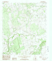
1984 Map of Noodle NE
USGS Topo · Published 1984About this map
The Clear Fork Brazos River winds across the center of this Jones County landscape, defining the topography of a region dominated by drainage networks and rolling plains. Surveyed in the late 1970s and edited in the early 1980s, the map reveals a rural Texas environment where water sources dictated the patterns of land use. Significant tributaries including Sweetwater Creek and Noodle Creek feed into the river system, while Thompson Creek marks the northeast corner of the quadrangle. The lack of concentrated settlements in this specific area highlights a landscape of dispersed ranching or agricultural activity, where geographic landmarks like river forks and creek confluences serve as the primary points of orientation for local history and land ownership research.
Find a feature on this map
4 named features on this map. Tap any name to fly to it.
Don’t see what you’re looking for? This feature index may not catch every label — zoom into the map to look around manually.
Map Details
Editions of this 1984 Noodle NE Map
This is the sole edition of this map. No revisions or reprints were ever made.
Other maps of this area

1891 · Anson
USGS Topo · 1:125,000

1893 · Roby
USGS Topo · 1:125,000

1893 · Anson
USGS Topo · 1:125,000

1954 · Big Spring
USGS Topo · 1:250,000

1954 · Abilene
USGS Topo · 1:250,000

1957 · Hawley
USGS Topo · 1:62,500

1957 · Noodle
USGS Topo · 1:62,500

1958 · Big Spring
USGS Topo · 1:250,000

1958 · Abilene
USGS Topo · 1:250,000
1965 · Neinda
USGS Topo · 1:24,000