1900s (20th Century) Maps of Falls City, Texas
Explore 8 historic maps of Falls City from the 1900s (20th Century). These maps offer a rare glimpse into what life looked like during the 1900s — showing old roads, neighborhoods, homes, and landmarks that have changed or disappeared over time.
Whether you're researching your family's past, planning a metal detecting trip, or studying how Falls City's landscape evolved across the 1900s, these high-resolution maps are a powerful tool for exploring the history of this region.
- Focus on a specific era: All maps on this page are from the 1900s, giving you a focused view of this time period.
- See what’s changed: Compare century-old streets, trails, and buildings to today's modern landscape using overlays and satellite layers.
- Research with precision: Use these maps for genealogy, historical research, land use analysis, or educational projects.
- View, download, or print: Maps are fully viewable online in high resolution, and can be downloaded or printed for your own records.
Start exploring Falls City's history through authentic maps from the 1900s. This is your window into the past.
Falls City, TX maps
(8)- 1925 Map of Tordia No. 1
 1925 Tordia No. 11925 Print · USGSKarnes and Wilson Counties are documented here in the mid-1920s as rural agriculture and rail lines shaped the river valley. Genealogists can trace family landmarks and local education hubs like Deweeville, Froshinn Hall, and the Three Oaks School.
 - 1931 Map of Falls City
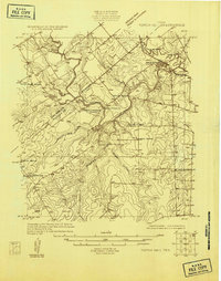
 1931 Falls City1931 Print · USGSSouth Texas river life and rail transport meet in this early thirties survey of Karnes and Wilson Counties. Trace the Southern Pacific through Falls City or locate rural landmarks like Froshinn Hall and Laake Sch.4 unique versions available
 - 1953 Map of Crystal City
 1953 Crystal City1953 Print · USGSSouth Texas in the early fifties was a landscape of expanding oil fields and vital rail connections. Genealogists and researchers can trace family lands along the Nueces River or locate heritage sites in Asherton, Big Wells, and Batesville.
 - 1955 Map of Crystal City, 1976 Print
 1955 Crystal City1976 Print · USGSSouth Texas ranching and oil country come into focus in the mid-fifties as the rail lines and rivers connect growing hubs. Researchers can trace the development of energy fields like Washburn Oil Field or locate historic settlements from Asherton to Three Rivers.
 - 1961 Map of Crystal City
 1961 Crystal City1961 Print · USGSSouth Texas in the early sixties reveals a landscape of massive cattle ranches and emerging oil fields. Genealogists and historians can trace the Missouri Pacific rail lines through Crystal City, or locate water features like Espantosa Lake and Boynton Reservoir.
 - 1961 Map of Falls City, 1963 Print
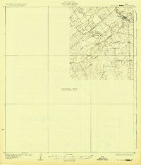
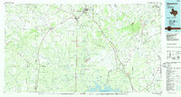
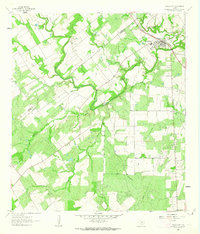 1961 Falls City1963 Print · USGSFalls City and the surrounding South Texas river country are shown here in the early sixties as the oil and quarrying industries expanded. Researchers can trace river crossings like Conquista Crossing, locate the Mueller Cem, and follow the Southern Pacific rail line.
 - 1968 Map of Crystal City
 1968 Crystal City1968 Print · USGSSouth Texas in the late sixties reveals a landscape shaped by ranching roots and the vital waters of the Nueces River. Researchers can trace the rail-driven growth of Crystal City or locate landmarks like Pilot Knob and Espantosa Lake.
 - 1985 Map of Pleasanton
 1985 Pleasanton1985 Print · USGSSouth Texas in the mid-1980s is characterized by the rise of petroleum and new water projects like the Choke Canyon Reservoir. Genealogists and historians can trace rail-side settlements along the Missouri Pacific and rural hubs such as Amphion, Fashing, and Campbellton.2 unique versions available
End of results
Showing maps 1-8 of 8
Top cities near Falls City
- San Antonio historical maps
- Floresville historical maps
- Karnes City historical maps
- Kenedy historical maps
- Poth historical maps
Frequently asked questions
- What are the different types of historical maps available for Falls City?
- What is the oldest map of Falls City?
- Where can I purchase historical maps of Falls City for my home or office?
- Where can I download high-res historical maps of Falls City?
- Are there historical topographic maps available for Falls City?
- Is there historical aerial imagery available for Falls City?
- Where are historical maps of Falls City sourced from?