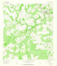
1961 Map of Falls City
USGS Topo · Published 1963About this map
Falls City serves as the primary hub of this landscape, situated at the confluence of the Southern Pacific railroad and the San Antonio River. The survey captures the transition between agricultural land and the burgeoning extraction industries of the early 1960s, evidenced by the numerous quarries and the presence of the Hobson Oil Field and Hysaw Oil Field Well. The river itself is a focal point of local geography and history, featuring named natural landmarks like Skiles Falls and established transit points such as Conquista Crossing and Moya Crossing. These crossings and falls reveal the historical reliance on specific river access points before modern infrastructure dominated the region. Rural life is further documented through family-named landmarks and essential community sites, including Falls City Cem and Mueller Cem, alongside various creek systems like Marcelinas Creek and Scared Dog Creek that define the drainage of the Wilson and Karnes county line.
Find a feature on this map
24 named features on this map. Tap any name to fly to it.
Don’t see what you’re looking for? This feature index may not catch every label — zoom into the map to look around manually.
Map Details
Editions of this 1961 Falls City Map
This is the sole edition of this map. No revisions or reprints were ever made.
Other maps of this area

1920 · Smiley
USGS Topo · 1:125,000

1925 · Tordia No. 1
USGS Topo · 1:48,000

1931 · Falls City
USGS Topo · 1:62,500

1936 · Floresville
USGS Topo · 1:62,500

1953 · Crystal City
USGS Topo · 1:250,000

1953 · Beeville
USGS Topo · 1:250,000

1953 · Seguin
USGS Topo · 1:250,000

1954 · San Antonio
USGS Topo · 1:250,000

1955 · Crystal City
USGS Topo · 1:250,000

1956 · Beeville
USGS Topo · 1:250,000