Old Maps of Wilson County, Texas
Explore 172 old maps of Wilson County, spanning from 1920 to today. These high-resolution historic maps reveal how streets, neighborhoods, landmarks, and natural features evolved over time — perfect for genealogy, metal detecting, research, and local history exploration.
What you can do with these maps:
- See how Wilson County changed over time: Compare historical maps to modern-day views to trace roads, homesites, rail lines & more.
- View detailed metadata: Each map includes creators, publishers, year, scale, and archive source.
- Overlay maps with satellite & LiDAR: Visualize the past alongside modern tools to explore terrain & human change.
- Trusted historical sources: Maps sourced from the USGS, Library of Congress, and other archives.
- Access maps your way: View online, download high-res files, or order prints for personal or research use.
Start exploring old maps of Wilson County to uncover forgotten places, hidden landmarks, and the deep history beneath your feet.
Wilson County, TX maps
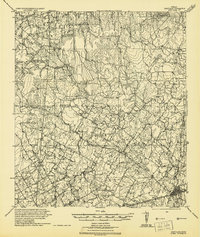
(172)- 1920 Map of Smiley
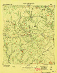 1920 Smiley1920 Print · USGSSouth Texas ranching and rail life are preserved here in the era following the first World War. Genealogists can trace family roots through labeled landmarks like Willow Springs Ranch, the Southern Pacific Railroad, and the settlement at Nixon.
 - 1925 Map of Tordia No. 1
 1925 Tordia No. 11925 Print · USGSKarnes and Wilson Counties are documented here in the mid-1920s as rural agriculture and rail lines shaped the river valley. Genealogists can trace family landmarks and local education hubs like Deweeville, Froshinn Hall, and the Three Oaks School.
 - 1931 Map of Falls City
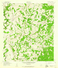
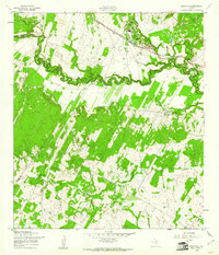
 1931 Falls City1931 Print · USGSSouth Texas river life and rail transport meet in this early thirties survey of Karnes and Wilson Counties. Trace the Southern Pacific through Falls City or locate rural landmarks like Froshinn Hall and Laake Sch.4 unique versions available
 - 1936 Map of Floresville, 1958 Print
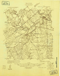
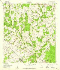
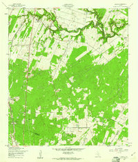
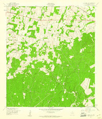
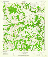
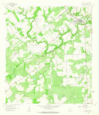
 1936 Floresville1958 Print · USGSWilson County was a landscape of independent ranches and river-bend missions in the mid-1930s. Genealogists can locate family landmarks like Dewees Ranch, rural schoolhouses such as Green School, and the historic site of Mission de las Cabras.
 - 1942 Map of Dewville
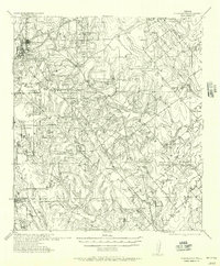
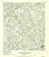
 1942 Dewville1942 Print · USGSThe rural borderlands of South Texas are mapped here just before the mid-century, showing a landscape of family ranches and crossroads stores. Researchers can locate ancestral sites like Thomas Springs Ranch and long-standing community centers such as Bethel School and Zion Hill Church.
 - 1953 Map of Crystal City
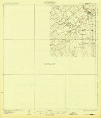
 1953 Crystal City1953 Print · USGSSouth Texas in the early fifties was a landscape of expanding oil fields and vital rail connections. Genealogists and researchers can trace family lands along the Nueces River or locate heritage sites in Asherton, Big Wells, and Batesville.
 - 1953 Map of Elmendorf, 1959 Print
 1953 Elmendorf1959 Print · USGSSoutheast of San Antonio in the early fifties, this area shows a landscape defined by the Southern Pacific rail line and active petroleum production. Genealogists can trace family names at the Cantu Cem and Flores Cem or locate the old Parita Ch.
 - 1953 Map of Seguin, 1965 Print
 1953 Seguin1965 Print · USGSSouth Texas in the early fifties shows a thriving river-and-rail economy across the Guadalupe and Colorado basins. Genealogists and historians can trace rail routes like the Southern Pacific through Seguin, locate oil wells, or find the Gary AAF near San Marcos.4 unique versions available
 - 1954 Map of San Antonio, 1964 Print
 1954 San Antonio1964 Print · USGSSan Antonio and the Texas Hill Country are captured here in the mid-fifties, showing a landscape defined by massive military air bases and the rising Canyon Reservoir. Trace family ties through historic rail towns like D'Hanis and Castroville or explore the Cold War footprint of Lackland AFB and Randolph AFB.3 unique versions available
 - 1955 Map of Crystal City, 1976 Print
 1955 Crystal City1976 Print · USGSSouth Texas ranching and oil country come into focus in the mid-fifties as the rail lines and rivers connect growing hubs. Researchers can trace the development of energy fields like Washburn Oil Field or locate historic settlements from Asherton to Three Rivers.
 - 1956 Map of Pleasanton
 1956 Pleasanton1956 Print · USGSPleasanton and the surrounding Atascosa County ranches appear here as they were mapped between the world wars. Genealogists and local historians can trace family properties like the Coughran Ranch and find rural landmarks like Hickcock School and the Temple church.
 - 1956 Map of Dewville
 1956 Dewville1956 Print · USGSGuadalupe and Wilson counties are captured here in the mid-1930s, showing a landscape defined by cattle ranching and rural schools. Genealogists can trace family homesteads like Joe Cliff Ranch and Ballard and Place Ranch or find ancestral sites at Zion Hill Church.
 - 1957 Map of San Antonio
 1957 San Antonio1957 Print · USGSSan Antonio and the Texas Hill Country are shown here during the mid-fifties, capturing the region's expanding post-war military and transportation footprint. Genealogists and local historians can trace the early residential boundaries of Alamo Heights or locate rural landmarks like St Hedwig and Medina Lake.
 - 1957 Map of New Berlin, 1961 Print
 1957 New Berlin1961 Print · USGSGuadalupe County rural life in the late fifties was a mix of quiet farming communities and active oil exploration. Genealogists can locate family landmarks like the Sweet Home Sch, Linne Cem, and the settlement of New Berlin before modern development.2 unique versions available
 - 1958 Map of Seguin
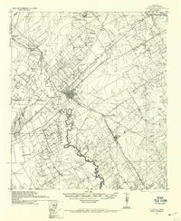
 1958 Seguin1958 Print · USGSSouth Texas in the late fifties was a network of river-valley settlements and active oilfields tied together by major rail lines. Genealogists and historians can trace family-named sites across Rabb Prairie, locate the Behring Store, or follow the Southern Pacific through Schulenburg.
 - 1958 Map of Losoya, 1961 Print
 1958 Losoya1961 Print · USGSBexar County south of San Antonio was a landscape of river-valley settlements and rural education during the late 1950s. Genealogists and local historians can locate Our Lady of Mt Carmel Ch, the community of Losoya, and the Thelma Sch along the Missouri Pacific line.3 unique versions available
 - 1958 Map of La Vernia SW, 1961 Print
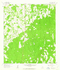
 1958 La Vernia SW1961 Print · USGSThe Wilson and Bexar County line in the late fifties was a rural landscape of oil exploration and rail transport. Genealogists and local historians can trace the Cooksey Oil Field, the La Vernia Cem, and the old Grass Pond Colony settlement.2 unique versions available
 - 1958 Map of Saspamco, 1961 Print
 1958 Saspamco1961 Print · USGSThe San Antonio River valley south of San Antonio comes into focus in the late fifties, showing a rural landscape of small settlements and rail stops. Local researchers can trace family roots through sites like Guadalupe Ch and the quiet community of Graytown.2 unique versions available
 - 1958 Map of Saint Hedwig, 1961 Print
 1958 Saint Hedwig1961 Print · USGSEast of San Antonio in the late fifties, this area shows the meeting point of Bexar, Guadalupe, and Wilson counties. Trace the rural landscape through Saint Hedwig and Zuehl, locating family landmarks like Goebel Sch and Hebron Ch.2 unique versions available
 - 1960 Map of Kosciusko, 1961 Print
 1960 Kosciusko1961 Print · USGSPolish-Texan heritage in the early sixties is preserved on this survey of the Wilson and Karnes county line. Genealogists and researchers can trace the rural landscape surrounding Kosciusko, including local landmarks like St Anns Ch, Pulaski Sch, and the winding Cibolo Creek.2 unique versions available
 - 1961 Map of Crystal City
 1961 Crystal City1961 Print · USGSSouth Texas in the early sixties reveals a landscape of massive cattle ranches and emerging oil fields. Genealogists and historians can trace the Missouri Pacific rail lines through Crystal City, or locate water features like Espantosa Lake and Boynton Reservoir.
 - 1961 Map of Nixon, 1963 Print
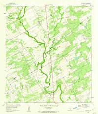
 1961 Nixon1963 Print · USGSThe South Texas prairie around Nixon is captured here in the early 1960s, showing a landscape shaped by the Southern Pacific railroad and local industry. Researchers can find many family landmarks, from the Claypits to rural sites like Union Valley Ch and Dewville Cem.3 unique versions available
 - 1961 Map of Stockdale, 1963 Print
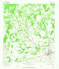
 1961 Stockdale1963 Print · USGSStockdale and the surrounding Wilson County ranch lands are documented here in the early sixties as the regional economy shifted from rail to oil. Researchers can trace family roots at Denhawken, the Dilworth Ranch Sch, and the Denhawken Cem.2 unique versions available
 - 1961 Map of Falls City, 1963 Print
 1961 Falls City1963 Print · USGSFalls City and the surrounding South Texas river country are shown here in the early sixties as the oil and quarrying industries expanded. Researchers can trace river crossings like Conquista Crossing, locate the Mueller Cem, and follow the Southern Pacific rail line.
 - 1961 Map of Thomas Springs, 1963 Print
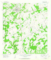
 1961 Thomas Springs1963 Print · USGSThe Guadalupe and Wilson county line comes alive in the early sixties, showing a landscape of dispersed ranches and creek-side communities. Genealogists can trace family footprints at Zion Hill Cem, Weinert Ranch, and Jakes Colony Ch.3 unique versions available
Showing maps 1-25 of 172
Top cities of Wilson County
Frequently asked questions
- What are the different types of historical maps available for Wilson County?
- What is the oldest map of Wilson County?
- Where can I purchase historical maps of Wilson County for my home or office?
- Where can I download high-res historical maps of Wilson County?
- Are there historical topographic maps available for Wilson County?
- Is there historical aerial imagery available for Wilson County?
- Where are historical maps of Wilson County sourced from?