1950s Maps of Wilson County, Texas
Explore 14 historic maps of Wilson County from the 1950s. These maps offer a rare glimpse into what life looked like during the 1950s — showing old roads, neighborhoods, homes, and landmarks that have changed or disappeared over time.
Whether you're researching your family's past, planning a metal detecting trip, or studying how Wilson County's landscape evolved across the 1950s, these high-resolution maps are a powerful tool for exploring the history of this region.
- Focus on a specific era: All maps on this page are from the 1950s, giving you a focused view of this time period.
- See what’s changed: Compare century-old streets, trails, and buildings to today's modern landscape using overlays and satellite layers.
- Research with precision: Use these maps for genealogy, historical research, land use analysis, or educational projects.
- View, download, or print: Maps are fully viewable online in high resolution, and can be downloaded or printed for your own records.
Start exploring Wilson County's history through authentic maps from the 1950s. This is your window into the past.
Wilson County, TX maps
(14)- 1953 Map of Crystal City
 1953 Crystal City1953 Print · USGSSouth Texas in the early fifties was a landscape of expanding oil fields and vital rail connections. Genealogists and researchers can trace family lands along the Nueces River or locate heritage sites in Asherton, Big Wells, and Batesville.
 - 1953 Map of Elmendorf, 1959 Print
 1953 Elmendorf1959 Print · USGSSoutheast of San Antonio in the early fifties, this area shows a landscape defined by the Southern Pacific rail line and active petroleum production. Genealogists can trace family names at the Cantu Cem and Flores Cem or locate the old Parita Ch.
 - 1953 Map of Seguin, 1965 Print
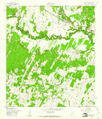
 1953 Seguin1965 Print · USGSSouth Texas in the early fifties shows a thriving river-and-rail economy across the Guadalupe and Colorado basins. Genealogists and historians can trace rail routes like the Southern Pacific through Seguin, locate oil wells, or find the Gary AAF near San Marcos.4 unique versions available
 - 1954 Map of San Antonio, 1964 Print
 1954 San Antonio1964 Print · USGSSan Antonio and the Texas Hill Country are captured here in the mid-fifties, showing a landscape defined by massive military air bases and the rising Canyon Reservoir. Trace family ties through historic rail towns like D'Hanis and Castroville or explore the Cold War footprint of Lackland AFB and Randolph AFB.3 unique versions available
 - 1955 Map of Crystal City, 1976 Print
 1955 Crystal City1976 Print · USGSSouth Texas ranching and oil country come into focus in the mid-fifties as the rail lines and rivers connect growing hubs. Researchers can trace the development of energy fields like Washburn Oil Field or locate historic settlements from Asherton to Three Rivers.
 - 1956 Map of Pleasanton
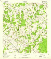
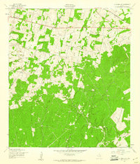
 1956 Pleasanton1956 Print · USGSPleasanton and the surrounding Atascosa County ranches appear here as they were mapped between the world wars. Genealogists and local historians can trace family properties like the Coughran Ranch and find rural landmarks like Hickcock School and the Temple church.
 - 1956 Map of Dewville
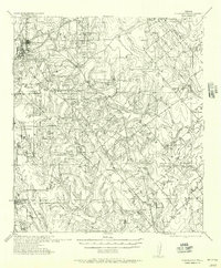
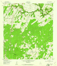
 1956 Dewville1956 Print · USGSGuadalupe and Wilson counties are captured here in the mid-1930s, showing a landscape defined by cattle ranching and rural schools. Genealogists can trace family homesteads like Joe Cliff Ranch and Ballard and Place Ranch or find ancestral sites at Zion Hill Church.
 - 1957 Map of San Antonio
 1957 San Antonio1957 Print · USGSSan Antonio and the Texas Hill Country are shown here during the mid-fifties, capturing the region's expanding post-war military and transportation footprint. Genealogists and local historians can trace the early residential boundaries of Alamo Heights or locate rural landmarks like St Hedwig and Medina Lake.
 - 1957 Map of New Berlin, 1961 Print
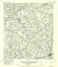
 1957 New Berlin1961 Print · USGSGuadalupe County rural life in the late fifties was a mix of quiet farming communities and active oil exploration. Genealogists can locate family landmarks like the Sweet Home Sch, Linne Cem, and the settlement of New Berlin before modern development.2 unique versions available
 - 1958 Map of Seguin
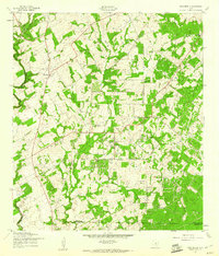
 1958 Seguin1958 Print · USGSSouth Texas in the late fifties was a network of river-valley settlements and active oilfields tied together by major rail lines. Genealogists and historians can trace family-named sites across Rabb Prairie, locate the Behring Store, or follow the Southern Pacific through Schulenburg.
 - 1958 Map of Losoya, 1961 Print
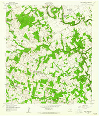
 1958 Losoya1961 Print · USGSBexar County south of San Antonio was a landscape of river-valley settlements and rural education during the late 1950s. Genealogists and local historians can locate Our Lady of Mt Carmel Ch, the community of Losoya, and the Thelma Sch along the Missouri Pacific line.3 unique versions available
 - 1958 Map of La Vernia SW, 1961 Print
 1958 La Vernia SW1961 Print · USGSThe Wilson and Bexar County line in the late fifties was a rural landscape of oil exploration and rail transport. Genealogists and local historians can trace the Cooksey Oil Field, the La Vernia Cem, and the old Grass Pond Colony settlement.2 unique versions available
 - 1958 Map of Saspamco, 1961 Print
 1958 Saspamco1961 Print · USGSThe San Antonio River valley south of San Antonio comes into focus in the late fifties, showing a rural landscape of small settlements and rail stops. Local researchers can trace family roots through sites like Guadalupe Ch and the quiet community of Graytown.2 unique versions available
 - 1958 Map of Saint Hedwig, 1961 Print
 1958 Saint Hedwig1961 Print · USGSEast of San Antonio in the late fifties, this area shows the meeting point of Bexar, Guadalupe, and Wilson counties. Trace the rural landscape through Saint Hedwig and Zuehl, locating family landmarks like Goebel Sch and Hebron Ch.2 unique versions available
End of results
Showing maps 1-14 of 14
Top cities of Wilson County
Frequently asked questions
- What are the different types of historical maps available for Wilson County?
- What is the oldest map of Wilson County?
- Where can I purchase historical maps of Wilson County for my home or office?
- Where can I download high-res historical maps of Wilson County?
- Are there historical topographic maps available for Wilson County?
- Is there historical aerial imagery available for Wilson County?
- Where are historical maps of Wilson County sourced from?