1960s Maps of Terrell, Texas
Explore 4 historic maps of Terrell from the 1960s. These maps offer a rare glimpse into what life looked like during the 1960s — showing old roads, neighborhoods, homes, and landmarks that have changed or disappeared over time.
Whether you're researching your family's past, planning a metal detecting trip, or studying how Terrell's landscape evolved across the 1960s, these high-resolution maps are a powerful tool for exploring the history of this region.
- Focus on a specific era: All maps on this page are from the 1960s, giving you a focused view of this time period.
- See what’s changed: Compare century-old streets, trails, and buildings to today's modern landscape using overlays and satellite layers.
- Research with precision: Use these maps for genealogy, historical research, land use analysis, or educational projects.
- View, download, or print: Maps are fully viewable online in high resolution, and can be downloaded or printed for your own records.
Start exploring Terrell's history through authentic maps from the 1960s. This is your window into the past.
Terrell, TX maps
(4)- 1962 Map of Elmo, 1965 Print
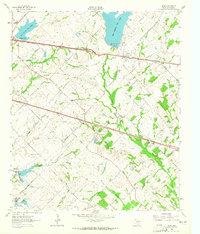 1962 Elmo1965 Print · USGSKaufman County's rural landscape is captured here in the early sixties as a major new highway was being carved through the countryside. Genealogists can locate family landmarks like Elmo Cem, College Mound, and the rural Black Jack Ch.2 unique versions available
 - 1962 Map of Terrell North, 1966 Print
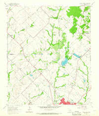 1962 Terrell North1966 Print · USGSKaufman County in the early sixties reveals a landscape of small farming communities and the steady growth of Terrell. Trace historical footprints at Chisholm and Colquitt, or follow the Texas and Pacific Railroad line.
 - 1963 Map of Forney South
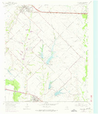 1963 Forney South1963 Print · USGSKaufman County agricultural life is captured here in the 1960s as water management projects began to reshape the Trinity River basin. Researchers can trace the rail lines of the Southern Pacific and locate family burial grounds like Shipley Cem and Antioch Cem.3 unique versions available
 - 1963 Map of Terrell South, 1965 Print
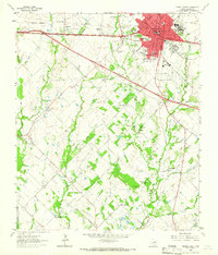 1963 Terrell South1965 Print · USGSTerrell enters a period of modern expansion in the early sixties as new four-lane highways are carved through the Kaufman County countryside. Researchers can trace historic family burial sites and rural communities like Union Valley, Post Oak Bend, and the East Bachelor Cemeteries.
End of results
Showing maps 1-4 of 4
Top cities near Terrell
- Dallas historical maps
- Garland historical maps
- Mesquite historical maps
- Rowlett historical maps
- Rockwall historical maps
- Forney historical maps
See more
Frequently asked questions
- What are the different types of historical maps available for Terrell?
- What is the oldest map of Terrell?
- Where can I purchase historical maps of Terrell for my home or office?
- Where can I download high-res historical maps of Terrell?
- Are there historical topographic maps available for Terrell?
- Is there historical aerial imagery available for Terrell?
- Where are historical maps of Terrell sourced from?