1980s Maps of Kerr County, Texas
Explore 4 historic maps of Kerr County from the 1980s. These maps offer a rare glimpse into what life looked like during the 1980s — showing old roads, neighborhoods, homes, and landmarks that have changed or disappeared over time.
Whether you're researching your family's past, planning a metal detecting trip, or studying how Kerr County's landscape evolved across the 1980s, these high-resolution maps are a powerful tool for exploring the history of this region.
- Focus on a specific era: All maps on this page are from the 1980s, giving you a focused view of this time period.
- See what’s changed: Compare century-old streets, trails, and buildings to today's modern landscape using overlays and satellite layers.
- Research with precision: Use these maps for genealogy, historical research, land use analysis, or educational projects.
- View, download, or print: Maps are fully viewable online in high resolution, and can be downloaded or printed for your own records.
Start exploring Kerr County's history through authentic maps from the 1980s. This is your window into the past.
Kerr County, TX maps
(4)- 1985 Map of New Braunfels
 1985 New Braunfels1985 Print · USGSThe Texas Hill Country meets the growing San Antonio suburbs in the mid-1980s, showing a landscape of river-fed towns and military grounds. Trace family roots in historic Gruene or Boerne, and locate landmarks like Canyon Lake and Randolph Air Force Base.
 - 1985 Map of Kerrville
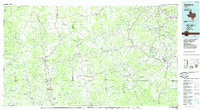
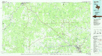 1985 Kerrville1985 Print · USGSThe Texas Hill Country comes into focus in the mid-eighties as a landscape of ranching roads and river headwaters. Trace the historic sites of Old Noxville, the remote Garven Store, and the early campus of Schreiner College.2 unique versions available
 - 1985 Map of Bandera
 1985 Bandera1985 Print · USGSThe Texas Hill Country in the mid-eighties was a land of winding river valleys and high limestone ridges. You can trace the rural road networks and find local landmarks like Garner State Park, Utopia, and Lost Maples State Park.2 unique versions available
 - 1985 Map of Pedernales River
 1985 Pedernales River1985 Print · USGSThe Texas Hill Country comes alive in the mid-1980s, documenting a landscape of ranching roots and presidential history. Researchers can trace historic settlements like Luckenbach, the presidential grounds of Lyndon B. Johnson National Historic Park, and the early rail path of the Southern Pacific Railroad.2 unique versions available
End of results
Showing maps 1-4 of 4
Top cities of Kerr County
- Kerrville historical maps
- Center Point historical maps
- Ingram historical maps
- Camp Verde historical maps
Frequently asked questions
- What are the different types of historical maps available for Kerr County?
- What is the oldest map of Kerr County?
- Where can I purchase historical maps of Kerr County for my home or office?
- Where can I download high-res historical maps of Kerr County?
- Are there historical topographic maps available for Kerr County?
- Is there historical aerial imagery available for Kerr County?
- Where are historical maps of Kerr County sourced from?