1900s (20th Century) Maps of Ingram, Texas
Explore 6 historic maps of Ingram from the 1900s (20th Century). These maps offer a rare glimpse into what life looked like during the 1900s — showing old roads, neighborhoods, homes, and landmarks that have changed or disappeared over time.
Whether you're researching your family's past, planning a metal detecting trip, or studying how Ingram's landscape evolved across the 1900s, these high-resolution maps are a powerful tool for exploring the history of this region.
- Focus on a specific era: All maps on this page are from the 1900s, giving you a focused view of this time period.
- See what’s changed: Compare century-old streets, trails, and buildings to today's modern landscape using overlays and satellite layers.
- Research with precision: Use these maps for genealogy, historical research, land use analysis, or educational projects.
- View, download, or print: Maps are fully viewable online in high resolution, and can be downloaded or printed for your own records.
Start exploring Ingram's history through authentic maps from the 1900s. This is your window into the past.
Ingram, TX maps
(6)- 1954 Map of Llano, 1964 Print
 1954 Llano1964 Print · USGSThe Texas Hill Country and Highland Lakes appear in the mid-fifties, just as new reservoirs began reshaping the landscape. Trace ranching history and river routes from Mason to Llano, or follow the Gulf Colorado and Santa Fe RR past Buchanan Lake.2 unique versions available
 - 1955 Map of Llano
 1955 Llano1955 Print · USGSCentral Texas and the Hill Country are seen here during the mid-1950s growth of the Highland Lakes. Trace old settlements and geologic landmarks from Enchanted Rock and Longhorn Cavern to the small community of Luckenbach.
 - 1956 Map of Llano, 1976 Print
 1956 Llano1976 Print · USGSThe Texas Hill Country comes alive in this mid-seventies survey of the Llano Uplift and Colorado River lakes. Genealogists and historians can trace family roots through settlements like Luckenbach and Castell or locate the famed L B J Ranch and Enchanted Rock.
 - 1964 Map of Kerrville, 1967 Print
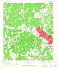 1964 Kerrville1967 Print · USGSThe Texas Hill Country centers on the winding Guadalupe River during a period of steady institutional and residential growth in the mid-sixties. Genealogists and historians can locate family landmarks like the Nichols Cem, the Schreiner Institute campus, and the early grounds of Old Lake Ingram.3 unique versions available
 - 1964 Map of Hunt, 1967 Print
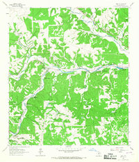 1964 Hunt1967 Print · USGSThe Texas Hill Country near the forks of the Guadalupe River was a hub for summer camps and family ranches in the early 1960s. Genealogists and historians can trace the foundations of Hunt, local burials at Hunt Cem, and recreation at Camp Rio Vista or Camp Stewart.3 unique versions available
 - 1985 Map of Kerrville
 1985 Kerrville1985 Print · USGSThe Texas Hill Country comes into focus in the mid-eighties as a landscape of ranching roads and river headwaters. Trace the historic sites of Old Noxville, the remote Garven Store, and the early campus of Schreiner College.2 unique versions available
End of results
Showing maps 1-6 of 6
Top cities near Ingram
- Kerrville historical maps
- Center Point historical maps
- Harper historical maps
- Camp Verde historical maps
Frequently asked questions
- What are the different types of historical maps available for Ingram?
- What is the oldest map of Ingram?
- Where can I purchase historical maps of Ingram for my home or office?
- Where can I download high-res historical maps of Ingram?
- Are there historical topographic maps available for Ingram?
- Is there historical aerial imagery available for Ingram?
- Where are historical maps of Ingram sourced from?