1980s Maps of Paris, Texas
Explore 4 historic maps of Paris from the 1980s. These maps offer a rare glimpse into what life looked like during the 1980s — showing old roads, neighborhoods, homes, and landmarks that have changed or disappeared over time.
Whether you're researching your family's past, planning a metal detecting trip, or studying how Paris's landscape evolved across the 1980s, these high-resolution maps are a powerful tool for exploring the history of this region.
- Focus on a specific era: All maps on this page are from the 1980s, giving you a focused view of this time period.
- See what’s changed: Compare century-old streets, trails, and buildings to today's modern landscape using overlays and satellite layers.
- Research with precision: Use these maps for genealogy, historical research, land use analysis, or educational projects.
- View, download, or print: Maps are fully viewable online in high resolution, and can be downloaded or printed for your own records.
Start exploring Paris's history through authentic maps from the 1980s. This is your window into the past.
Paris, TX maps
(4)- 1984 Map of Biardstown
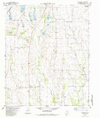 1984 Biardstown1984 Print · USGSSoutheast of Paris, Texas, in the late seventies, this rural landscape centers on the small agricultural hub of Biardstown. Researchers can trace old family roots and land use patterns through numerous landmarks like Mc Donald Cem, Delmar Sch, and the vanished tracks of an Old Railroad Grade.
 - 1984 Map of Toco, 1985 Print
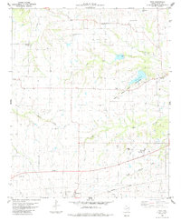 1984 Toco1985 Print · USGSLamar County in the mid-1980s was a landscape of small agricultural hubs and vital watercourses. Genealogists can trace family landmarks at Shiloh Cemetery and Jackson Cemetery, while rail historians can follow the Missouri Pacific line through Brookston.
 - 1984 Map of Paris, 1985 Print
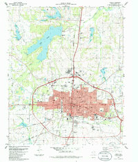 1984 Paris1985 Print · USGSThe rail-and-road network of Paris, Texas, is captured here in the mid-eighties, showing a bustling county seat at a point of significant transition. Researchers can locate specific neighborhood institutions like the First Ward Sch, trace the old Missouri Pacific Railroad lines, or find family plots in Evergreen Cem.
 - 1985 Map of Paris
 1985 Paris1985 Print · USGSThe Red River Valley in the mid-eighties shows a landscape of military training grounds and rail-connected agricultural towns. Genealogists and historians can trace local landmarks like Allens Chapel Cem, the grounds of Camp Maxey, and the early footprint of Paris Junior College.
End of results
Showing maps 1-4 of 4
Top cities near Paris
- Reno historical maps
- Blossom historical maps
- Roxton historical maps
- Toco historical maps
- Sun Valley historical maps
Top neighborhoods of Paris
Frequently asked questions
- What are the different types of historical maps available for Paris?
- What is the oldest map of Paris?
- Where can I purchase historical maps of Paris for my home or office?
- Where can I download high-res historical maps of Paris?
- Are there historical topographic maps available for Paris?
- Is there historical aerial imagery available for Paris?
- Where are historical maps of Paris sourced from?