1960s Maps of Paris, Texas
Explore 2 historic maps of Paris from the 1960s. These maps offer a rare glimpse into what life looked like during the 1960s — showing old roads, neighborhoods, homes, and landmarks that have changed or disappeared over time.
Whether you're researching your family's past, planning a metal detecting trip, or studying how Paris's landscape evolved across the 1960s, these high-resolution maps are a powerful tool for exploring the history of this region.
- Focus on a specific era: All maps on this page are from the 1960s, giving you a focused view of this time period.
- See what’s changed: Compare century-old streets, trails, and buildings to today's modern landscape using overlays and satellite layers.
- Research with precision: Use these maps for genealogy, historical research, land use analysis, or educational projects.
- View, download, or print: Maps are fully viewable online in high resolution, and can be downloaded or printed for your own records.
Start exploring Paris's history through authentic maps from the 1960s. This is your window into the past.
Paris, TX maps
(2)- 1964 Map of Pattonville, 1967 Print
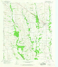 1964 Pattonville1967 Print · USGSLamar County's rural communities and creek-side settlements are captured here in the mid-1960s. Genealogists and local historians can trace family roots through landmarks like Biardstown Cem, the Plainview Community Hall, and the Old Railroad Grade that once spanned the county.
 - 1964 Map of Blossom, 1967 Print
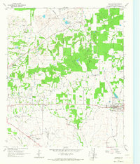 1964 Blossom1967 Print · USGSLamar County life centered on the rail-and-road corridor between Paris and Blossom during the mid-sixties. Researchers can trace family history at Corn Cem, Sikes Cem, or Providence Ch and locate era-specific landmarks like the Drive-in Theater and Cox Field.
End of results
Showing maps 1-2 of 2
Top cities near Paris
- Reno historical maps
- Blossom historical maps
- Roxton historical maps
- Toco historical maps
- Sun Valley historical maps
Top neighborhoods of Paris
Frequently asked questions
- What are the different types of historical maps available for Paris?
- What is the oldest map of Paris?
- Where can I purchase historical maps of Paris for my home or office?
- Where can I download high-res historical maps of Paris?
- Are there historical topographic maps available for Paris?
- Is there historical aerial imagery available for Paris?
- Where are historical maps of Paris sourced from?