1960s Maps of McLennan County, Texas
Explore 6 historic maps of McLennan County from the 1960s. These maps offer a rare glimpse into what life looked like during the 1960s — showing old roads, neighborhoods, homes, and landmarks that have changed or disappeared over time.
Whether you're researching your family's past, planning a metal detecting trip, or studying how McLennan County's landscape evolved across the 1960s, these high-resolution maps are a powerful tool for exploring the history of this region.
- Focus on a specific era: All maps on this page are from the 1960s, giving you a focused view of this time period.
- See what’s changed: Compare century-old streets, trails, and buildings to today's modern landscape using overlays and satellite layers.
- Research with precision: Use these maps for genealogy, historical research, land use analysis, or educational projects.
- View, download, or print: Maps are fully viewable online in high resolution, and can be downloaded or printed for your own records.
Start exploring McLennan County's history through authentic maps from the 1960s. This is your window into the past.
McLennan County, TX maps
(6)- 1965 Map of Troy, 1967 Print
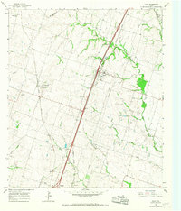 1965 Troy1967 Print · USGSBell County's agricultural heartland in the mid-sixties reveals a landscape shaped by competing rail lines and rural community centers. Genealogists can locate family names at Old Troy Cem, Pleasant View Cem, and the Willow Grove Ch.3 unique versions available
 - 1965 Map of Moody, 1967 Print
 1965 Moody1967 Print · USGSCentral Texas prairie life in the mid-sixties is captured here along the busy rail lines of the Santa Fe and M-K-T railroads. Genealogists can locate family landmarks like Perry Cem, Naler Cem, and the rural Liberty Hill Ch.3 unique versions available
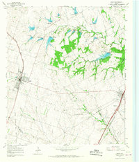
 - 1965 Map of Eagle Springs, 1968 Print
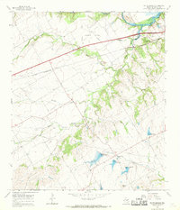
 1965 Eagle Springs1968 Print · USGSThe Leon River valley and the expanding Belton Reservoir define this mid-sixties survey of the Texas interior. Local researchers can locate rural landmarks like Stockton Chapel, the Atchison Topeka and Santa Fe rail line, and family cemeteries including Alexander Cemetery.2 unique versions available
 - 1965 Map of McGregor, 1969 Print
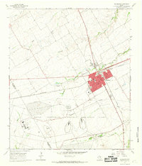 1965 McGregor1969 Print · USGSMcGregor stands at a major rail intersection in the mid-1960s, characterized by its transition from a transit hub to a center for military industry. Genealogists and historians can trace family plots at Comanche Springs Cemetery and study the massive Naval Industrial Reserve Ordinance Plant footprint.2 unique versions available
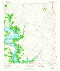
 - 1965 Map of South Bosque, 1969 Print
 1965 South Bosque1969 Print · USGSMcLennan County's suburban and rural landscape comes into focus in the mid-1960s as Woodway begins to expand near the shores of Lake Waco. Genealogists and historians can trace the paths of the St Louis Southwestern rail line or locate the historic Horne Cem and Harris Creek Ch.3 unique versions available
 - 1966 Map of Smiths Bend, 1969 Print
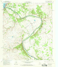 1966 Smiths Bend1969 Print · USGSThe Brazos River valley north of Waco in the mid-sixties reveals a landscape of limestone bluffs and rural settlements. Genealogists and historians can trace family sites at Smiths Bend-Coon Creek Cem or locate the old Spivey Crossing ford.2 unique versions available
End of results
Showing maps 1-6 of 6
Top cities of McLennan County
- Waco historical maps
- Hewitt historical maps
- Robinson historical maps
- Bellmead historical maps
- Woodway historical maps
- Lacy Lakeview historical maps
See more
Frequently asked questions
- What are the different types of historical maps available for McLennan County?
- What is the oldest map of McLennan County?
- Where can I purchase historical maps of McLennan County for my home or office?
- Where can I download high-res historical maps of McLennan County?
- Are there historical topographic maps available for McLennan County?
- Is there historical aerial imagery available for McLennan County?
- Where are historical maps of McLennan County sourced from?