1950s Maps of Medina County, Texas
Explore 9 historic maps of Medina County from the 1950s. These maps offer a rare glimpse into what life looked like during the 1950s — showing old roads, neighborhoods, homes, and landmarks that have changed or disappeared over time.
Whether you're researching your family's past, planning a metal detecting trip, or studying how Medina County's landscape evolved across the 1950s, these high-resolution maps are a powerful tool for exploring the history of this region.
- Focus on a specific era: All maps on this page are from the 1950s, giving you a focused view of this time period.
- See what’s changed: Compare century-old streets, trails, and buildings to today's modern landscape using overlays and satellite layers.
- Research with precision: Use these maps for genealogy, historical research, land use analysis, or educational projects.
- View, download, or print: Maps are fully viewable online in high resolution, and can be downloaded or printed for your own records.
Start exploring Medina County's history through authentic maps from the 1950s. This is your window into the past.
Medina County, TX maps
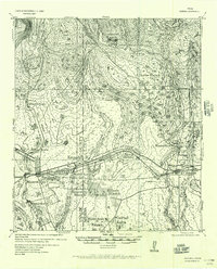
(9)- 1954 Map of San Antonio, 1964 Print
 1954 San Antonio1964 Print · USGSSan Antonio and the Texas Hill Country are captured here in the mid-fifties, showing a landscape defined by massive military air bases and the rising Canyon Reservoir. Trace family ties through historic rail towns like D'Hanis and Castroville or explore the Cold War footprint of Lackland AFB and Randolph AFB.3 unique versions available
 - 1956 Map of Sabinal
 1956 Sabinal1956 Print · USGSRanching and rail transit define this South Texas landscape in the mid-1950s. Genealogists and historians can trace family holdings like the A Rothe Ranch, locate the industry of the Brick Yard, and follow the old Fort Clark-San Antonio Road past Sabinal.
 - 1956 Map of New Fountain
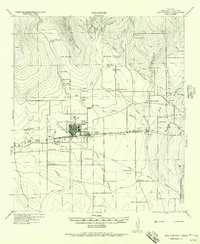 1956 New Fountain1956 Print · USGSMedina County comes into focus during the war years, showing a landscape defined by ranching and military training. Genealogy researchers can trace family lines through labeled homesteads like HJ Meyers and Lee Batot, or locate the Hondo Navigation School and Blue Waterhole.
 - 1956 Map of Tarpley
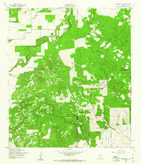
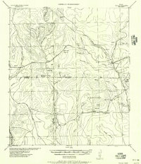 1956 Tarpley1956 Print · USGSThe Texas Hill Country around Tarpley comes into focus in this mid-century survey, showing the transition from family ranches to early industrial infrastructure. Trace old property lines and landmarks like Old Montell Camp, the German Settlement, and the Humble Pipeline.
 - 1956 Map of Bandera
 1956 Bandera1956 Print · USGSThe Texas Hill Country comes alive in the mid-1950s as a landscape of remote ranches and critical waterholes. Genealogists and historians can trace family holdings like Hanson Ranch or locate unique landmarks such as the Line Walkers Shanty and Bat Cave.
 - 1956 Map of Medina Lake
 1956 Medina Lake1956 Print · USGSMedina Lake and the surrounding Texas highlands are captured here in the 1920s and early 1930s. Genealogists and local historians can trace family properties like Kallison Ranch and the Granieri Hotel, or locate landmarks such as the Mico P.O. and Toll Gate.
 - 1957 Map of San Antonio
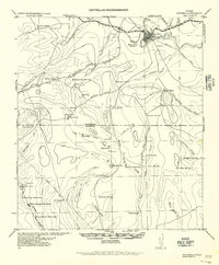
 1957 San Antonio1957 Print · USGSSan Antonio and the Texas Hill Country are shown here during the mid-fifties, capturing the region's expanding post-war military and transportation footprint. Genealogists and local historians can trace the early residential boundaries of Alamo Heights or locate rural landmarks like St Hedwig and Medina Lake.
 - 1958 Map of La Coste, 1961 Print
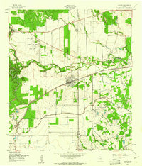 1958 La Coste1961 Print · USGSMedina County during the late fifties shows a rural landscape shaped by the Medina River and the expanding irrigation systems of South Texas. Researchers can find long-standing landmarks like Our Lady of Grace Sch and the Castroville Air Force Auxiliary Field.3 unique versions available
 - 1958 Map of La Coste NE, 1961 Print
 1958 La Coste NE1961 Print · USGSMedina and Bexar Counties are captured in the late fifties, showcasing a transitional landscape of central Texas creek beds and rising hills. Local historians can trace the intricate drainages of Potranca Creek, Medio Creek, and the slopes of Loma Alta.2 unique versions available
End of results
Showing maps 1-9 of 9
Top cities of Medina County
Frequently asked questions
- What are the different types of historical maps available for Medina County?
- What is the oldest map of Medina County?
- Where can I purchase historical maps of Medina County for my home or office?
- Where can I download high-res historical maps of Medina County?
- Are there historical topographic maps available for Medina County?
- Is there historical aerial imagery available for Medina County?
- Where are historical maps of Medina County sourced from?