1970s Maps of Medina County, Texas
Explore 10 historic maps of Medina County from the 1970s. These maps offer a rare glimpse into what life looked like during the 1970s — showing old roads, neighborhoods, homes, and landmarks that have changed or disappeared over time.
Whether you're researching your family's past, planning a metal detecting trip, or studying how Medina County's landscape evolved across the 1970s, these high-resolution maps are a powerful tool for exploring the history of this region.
- Focus on a specific era: All maps on this page are from the 1970s, giving you a focused view of this time period.
- See what’s changed: Compare century-old streets, trails, and buildings to today's modern landscape using overlays and satellite layers.
- Research with precision: Use these maps for genealogy, historical research, land use analysis, or educational projects.
- View, download, or print: Maps are fully viewable online in high resolution, and can be downloaded or printed for your own records.
Start exploring Medina County's history through authentic maps from the 1970s. This is your window into the past.
Medina County, TX maps
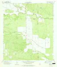
(10)- 1970 Map of San Geronimo, 1973 Print
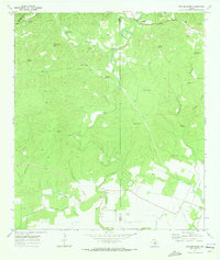 1970 San Geronimo1973 Print · USGSThe Texas Hill Country ranching culture is well preserved in this 1970s survey, showing large estates and remote water sources. Researchers can locate family sites like Lee Cem, the Maverick Sch, and landmarks including Blue Gallagher Heaven.3 unique versions available
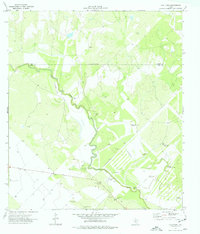
 - 1970 Map of Irishman Hill, 1973 Print
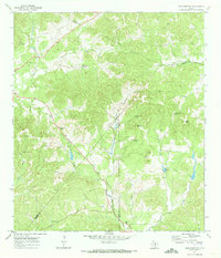
 1970 Irishman Hill1973 Print · USGSSettled along the border of Uvalde and Medina counties in the early 1970s, this landscape shows the rural intersection of the Sabinal River and its many tributaries. Genealogists and local historians can locate the Brown Cem and landmarks like Irishman Hill and Pilot Knob.
 - 1970 Map of Murphy School, 1973 Print
 1970 Murphy School1973 Print · USGSMedina County rural life in the late sixties is centered on the drainage of Hondo Creek and the Southern Pacific line. Genealogists and historians can locate the Murphy Sch, a local Cem, and numerous Oil Wells across the landscape.2 unique versions available
 - 1970 Map of D'hanis, 1973 Print
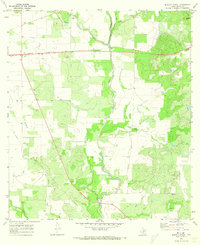
 1970 D'hanis1973 Print · USGSMedina County comes into focus in the early 1970s, centered on the rail-side community of D'Hanis. Researchers can trace local lineage through several cemeteries like Rothe Cem and Cortez Cem, or locate early industry at the Kilns near the Southern Pacific tracks.2 unique versions available
 - 1970 Map of Hondo, 1973 Print
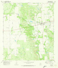
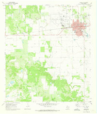 1970 Hondo1973 Print · USGSHondo sits at a crossroads of rail and air travel in the early 1970s, as the community expanded around the Southern Pacific tracks. Researchers can trace local lineage through St John Sch and Cottonwood Cem, or locate the historic Municipal Airport.2 unique versions available
 - 1970 Map of Sabinal, 1973 Print
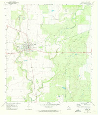 1970 Sabinal1973 Print · USGSThe community of Sabinal thrives at the intersection of rail and river during the early 1970s. Genealogists can locate family landmarks such as St Patrick Cem and Davenport Cem, or trace the Southern Pacific line past the local Rodeo Ground.
 - 1970 Map of Jack Mountain, 1973 Print
 1970 Jack Mountain1973 Print · USGSThe Texas Hill Country at the intersection of Bandera, Bexar, and Medina counties is captured here in the early seventies. Genealogists and local researchers can trace family landmarks like the Heimsath Cem and the Clifton Sch among the springs of San Geronimo Creek.2 unique versions available
 - 1970 Map of Frio Town NE, 1973 Print
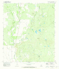
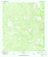 1970 Frio Town NE1973 Print · USGSMedina County ranch lands and drainage basins are captured here during the early 1970s. Researchers can trace rural water sources like Seco Creek alongside isolated landmarks such as a remote Landing Strip and various Gravel Pits.2 unique versions available
 - 1974 Map of Gross Tank, 1977 Print
 1974 Gross Tank1977 Print · USGSThe ranchlands of Zavala and Uvalde counties are captured here in the mid-1970s at a time of increasing energy exploration. Researchers can trace the water-dependent settlement patterns along the Frio River, identified by numerous Gas Wells and remote landmarks like Gross Tank.
 - 1974 Map of Frio Town, 1977 Print
 1974 Frio Town1977 Print · USGSThe ranchlands of South Texas are captured in the mid-1970s as the historic settlement of Frio Town remained a vital landmark. Researchers can trace the riverfront at Rock House Ranch, find the Frio Town Cem, and locate numerous family and industrial sites like TJ Windmill.
End of results
Showing maps 1-10 of 10
Top cities of Medina County
Frequently asked questions
- What are the different types of historical maps available for Medina County?
- What is the oldest map of Medina County?
- Where can I purchase historical maps of Medina County for my home or office?
- Where can I download high-res historical maps of Medina County?
- Are there historical topographic maps available for Medina County?
- Is there historical aerial imagery available for Medina County?
- Where are historical maps of Medina County sourced from?