1900s (20th Century) Maps of Mineral Wells, Texas
Explore 9 historic maps of Mineral Wells from the 1900s (20th Century). These maps offer a rare glimpse into what life looked like during the 1900s — showing old roads, neighborhoods, homes, and landmarks that have changed or disappeared over time.
Whether you're researching your family's past, planning a metal detecting trip, or studying how Mineral Wells's landscape evolved across the 1900s, these high-resolution maps are a powerful tool for exploring the history of this region.
- Focus on a specific era: All maps on this page are from the 1900s, giving you a focused view of this time period.
- See what’s changed: Compare century-old streets, trails, and buildings to today's modern landscape using overlays and satellite layers.
- Research with precision: Use these maps for genealogy, historical research, land use analysis, or educational projects.
- View, download, or print: Maps are fully viewable online in high resolution, and can be downloaded or printed for your own records.
Start exploring Mineral Wells's history through authentic maps from the 1900s. This is your window into the past.
Mineral Wells, TX maps
(9)- 1918 Map of Palo Pinto
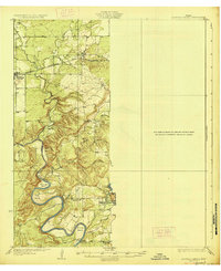
 1918 Palo Pinto1918 Print · USGSPalo Pinto County and the Brazos River valley appear here in the final year of the Great War, showing a landscape shaped by coal and steam. Genealogists and historians can locate defunct river crossings like Oaks Ferry, early rural education at Marsden School, and the extensive Coal Mines that once powered the regional economy.
 - 1927 Map of Mineral Wells
 1927 Mineral Wells1927 Print · USGSThe Brazos River carves a winding path through Palo Pinto County in the mid-1920s, defining a landscape of deep hollows and sharp river bends. Researchers can trace early rural schools like Union Hill School and the route of the Weatherford Mineral Wells and Northwestern rail line.2 unique versions available
 - 1954 Map of Abilene, 1966 Print
 1954 Abilene1966 Print · USGSThe Texas Big Country comes into focus in the mid-1950s as petroleum and new water projects reshape the landscape. Local historians can trace the Butterfield Trail, find the Fort Phantom Hill Ruins, and locate numerous small communities along the Texas & Pacific line.2 unique versions available
 - 1958 Map of Abilene
 1958 Abilene1958 Print · USGSMid-century West Texas comes alive in this survey of the Abilene and Stephenville region during a period of steady oil expansion and military growth. Genealogists and local historians can trace the paths of the Texas & Pacific RR through historic towns, locate the Fort Griffin Ruins, and find smaller settlements like Desdemona and Lueders.
 - 1959 Map of Mineral Wells, 1960 Print
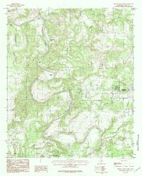
 1959 Mineral Wells1960 Print · USGSMineral Wells and the surrounding Palo Pinto ranch lands are captured here during the height of the Cold War helicopter training era. Researchers can trace the massive footprint of Camp Wolters, the winding Brazos River bends, and local landmarks like Staggs Prairie Cem.2 unique versions available
 - 1984 Map of Whitt
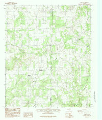 1984 Whitt1984 Print · USGSThe ranchlands along the Palo Pinto and Parker County border are documented here in the early 1980s. Local researchers can trace the rural layout of Whitt, Peadenville, and Salesville, along with landmarks like Rock Crusher Lake and Turkey Creek.
 - 1984 Map of Mineral Wells West
 1984 Mineral Wells West1984 Print · USGSThe western edges of Mineral Wells and the deep bends of the Brazos River are captured here in the late seventies and early eighties. Researchers can trace the river's winding path through Ballenger Bend or locate landmarks like Barber Mountain and Coronados Camp.2 unique versions available
 - 1984 Map of Mineral Wells East, 1986 Print
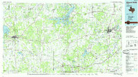
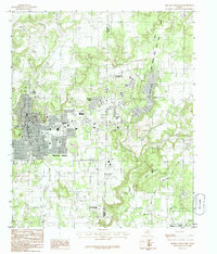 1984 Mineral Wells East1986 Print · USGSMineral Wells and its eastern neighbors are shown in the early 1980s as the region transitioned from military influence to recreation and education. Genealogists can trace family connections in Wolters Village, Sturdivant, or Millsap and locate landmarks like Weatherford College.
 - 1985 Map of Mineral Wells
 1985 Mineral Wells1985 Print · USGSNorth-central Texas in the mid-eighties shows a landscape of deep river valleys and massive reservoirs. Genealogists and historians can trace the Missouri Pacific rail line and locate rural settlements like Thurber, Necessity, and Palo Pinto.2 unique versions available
End of results
Showing maps 1-9 of 9
Top cities near Mineral Wells
- Graford historical maps
- Millsap historical maps
- Perrin historical maps
- Palo Pinto historical maps
- Cool historical maps
Top neighborhoods of Mineral Wells
Frequently asked questions
- What are the different types of historical maps available for Mineral Wells?
- What is the oldest map of Mineral Wells?
- Where can I purchase historical maps of Mineral Wells for my home or office?
- Where can I download high-res historical maps of Mineral Wells?
- Are there historical topographic maps available for Mineral Wells?
- Is there historical aerial imagery available for Mineral Wells?
- Where are historical maps of Mineral Wells sourced from?