1960s Maps of Navarro County, Texas
Explore 27 historic maps of Navarro County from the 1960s. These maps offer a rare glimpse into what life looked like during the 1960s — showing old roads, neighborhoods, homes, and landmarks that have changed or disappeared over time.
Whether you're researching your family's past, planning a metal detecting trip, or studying how Navarro County's landscape evolved across the 1960s, these high-resolution maps are a powerful tool for exploring the history of this region.
- Focus on a specific era: All maps on this page are from the 1960s, giving you a focused view of this time period.
- See what’s changed: Compare century-old streets, trails, and buildings to today's modern landscape using overlays and satellite layers.
- Research with precision: Use these maps for genealogy, historical research, land use analysis, or educational projects.
- View, download, or print: Maps are fully viewable online in high resolution, and can be downloaded or printed for your own records.
Start exploring Navarro County's history through authentic maps from the 1960s. This is your window into the past.
Navarro County, TX maps
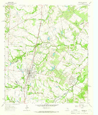
(27)- 1960 Map of Tool, 1961 Print
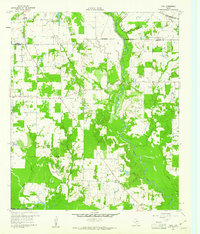 1960 Tool1961 Print · USGSThe rural Henderson County landscape of the early 1960s is preserved here, centered on the creek-fed agricultural lands near the Trinity River. Genealogists and local historians can trace the foundations of Tool, Tolosa, and Aley, alongside family landmarks like Baker Cem and King Cem.3 unique versions available
 - 1960 Map of Winkler, 1961 Print
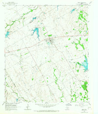
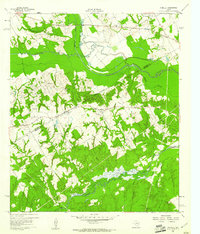 1960 Winkler1961 Print · USGSNavarro and Freestone Counties appear here in the early sixties as a network of creek-side settlements and rural churches. Genealogists and researchers can trace local roots at Winkler, St Elmo, and the Sweetman Cem.4 unique versions available
 - 1960 Map of Streetman, 1961 Print
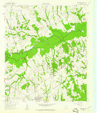 1960 Streetman1961 Print · USGSThe Navarro and Freestone county line comes alive in the early sixties, showing a landscape of rail-connected farming communities. Genealogists can locate family landmarks like Birdston Cem, Johnson Cem, and rural churches such as Friendship Ch.4 unique versions available
 - 1960 Map of Creslenn Ranch, 1961 Print
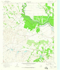
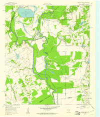 1960 Creslenn Ranch1961 Print · USGSThe Trinity River bottoms and the Cayuga oil country are captured here at the start of the 1960s. Genealogists and local historians can trace the Princeton Cem, the remote Creslenn Ranch, and landmarks like Hall Lake and Trinidad.3 unique versions available
 - 1960 Map of Goodlow Park, 1961 Print
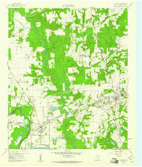
 1960 Goodlow Park1961 Print · USGSNavarro County life in the early sixties centers on small farming communities and the growing oil industry. Genealogists can locate family landmarks like Alligator Ch, Petersburg Cem, and the settlements of Rural Shade and Goodnight.3 unique versions available
 - 1960 Map of Malakoff, 1961 Print
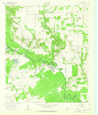
 1960 Malakoff1961 Print · USGSThe Trinity River valley in 1960 reveals a landscape of industrial power and small-town growth between Trinidad and Malakoff. Genealogists and historians can trace local landmarks like the St Paul Industrial Sch, Kilman Hospital, and Isaac Cem.4 unique versions available
 - 1960 Map of Roustabout Camp, 1961 Print
 1960 Roustabout Camp1961 Print · USGSThe Trinity River bottoms at the Freestone and Anderson county line show a busy mid-century landscape of energy production and river-fed agriculture. Genealogists and historians can trace industrial camps like Roustabout Camp and Amerada Camp or local landmarks such as Harp Ch.4 unique versions available
 - 1961 Map of Kerens, 1962 Print
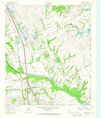
 1961 Kerens1962 Print · USGSKerens and the fertile Trinity River bottomlands are captured here in the early sixties, showing a landscape defined by rail, oil, and water. Genealogists and researchers can locate Oak Grove Ch, the Bazette Oil Field, and family-named water features like Singletary Lake.3 unique versions available
 - 1961 Map of Chatfield, 1966 Print
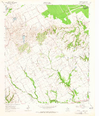
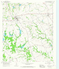
 1961 Chatfield1966 Print · USGSNavarro County's petroleum and agricultural heartland is documented here during the early sixties, showing the expansion of the Corsicana Oil Field. Genealogists and historians can trace family locations near Chatfield Cem, Roane, and the Tupelo Ch.
 - 1962 Map of Bazette, 1965 Print
 1962 Bazette1965 Print · USGSThe Trinity River bottomlands and the crossroads of Bazette are captured here in the early sixties. Genealogists and local historians can trace family locations through Phillips Cem, Roane Ch, and the numerous Oil Wells scattered across the prairie.2 unique versions available
 - 1962 Map of Emhouse, 1965 Print
 1962 Emhouse1965 Print · USGSNorth of Corsicana in the early sixties, the borderlands of Navarro and Ellis Counties supported a landscape of prairie creeks and busy rail lines. Trace family history near Emhouse, locate the Pattison Cem, and follow the path of the Rock Island and Pacific railroad.2 unique versions available
 - 1962 Map of Ennis East, 1965 Print
 1962 Ennis East1965 Print · USGSEastern Ellis County in the early 1960s shows a landscape of rail-linked prairie towns and country schools. Genealogists can trace family footprints at Redwine Cem, Alma, and the St Johns Ch.3 unique versions available
 - 1962 Map of Rosser SW, 1965 Print
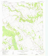
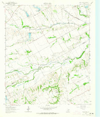
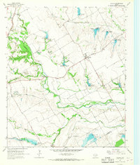
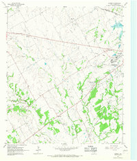
 1962 Rosser SW1965 Print · USGSNavarro County in the early 1960s was a landscape of rural family farms and emerging water management systems along the Trinity River. Local researchers can locate Rice Cem, the Hopewell Ch, and several named reservoirs along Grays Creek.
 - 1962 Map of Styx, 1965 Print
 1962 Styx1965 Print · USGSHenderson and Kaufman Counties in the early 1960s were defined by the deep bends of the Trinity River and small rural outposts. Researchers can trace family history at Timothy Cem, locate the old Finch Sch, or find the crossroads at Styx.2 unique versions available
 - 1962 Map of Cryer Creek, 1965 Print
 1962 Cryer Creek1965 Print · USGSThe Ellis and Navarro county line in the early sixties remains a landscape of quiet agrarian settlements and sprawling creek networks. Genealogists and local historians can trace family sites at Grange Hall Cem and Antioch Ch or locate the Flying Sams Airfield near Rankin.2 unique versions available
 - 1963 Map of Richland, 1966 Print
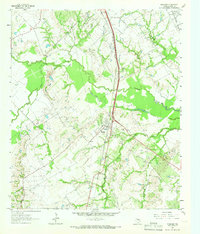 1963 Richland1966 Print · USGSThe Richland area in the early sixties is a study in Texas rail and oil history, centered on the crossing of the Southern Pacific and Fort Worth & Denver lines. Genealogists and researchers can trace local roots at Carroll Chapel Cem, Richland Sch, and the Powell Oil Field.2 unique versions available
 - 1963 Map of Wortham, 1966 Print
 1963 Wortham1966 Print · USGSThe community of Wortham sits at the heart of the Texas oil patch in the early sixties. Genealogists and researchers can trace the Southern Pacific rail line between Currie and Gude, and locate family sites like Miller Cem or Red Cem.2 unique versions available
 - 1963 Map of Kirvin, 1966 Print
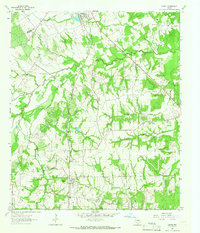 1963 Kirvin1966 Print · USGSFreestone County in the early sixties maintains its rural character through a series of small settlements and church communities. You can trace family roots at St Session Cemetery or explore the rail corridor of the Chicago Rock Island and Pacific.2 unique versions available
 - 1965 Map of Corsicana, 1967 Print
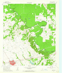
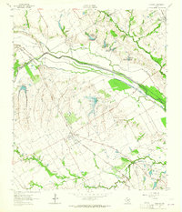
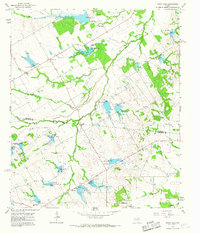
 1965 Corsicana1967 Print · USGSMid-century Navarro County is defined here by its expanding energy sector and the industrial footprint of the rail lines. Researchers can trace family history at Woodland Cemetery or locate old school sites like Crockett School and the Mildred-Navarro School Substation.3 unique versions available
 - 1965 Map of Coolidge, 1967 Print
 1965 Coolidge1967 Print · USGSCoolidge and the surrounding Limestone County prairie are captured here during a period of significant water management in the mid-sixties. Genealogists and local historians can trace the rural landscape through the Dover Cem and settlements like Munger or Calina.2 unique versions available
 - 1965 Map of Avalon, 1967 Print
 1965 Avalon1967 Print · USGSSouthern Ellis County is captured here in the mid-sixties, a landscape of family farms and extensive creek-side water management. Researchers can locate the Missouri-Kansas-Texas rail line, local landmarks like Forreston Cem, and the rural community of Avalon.2 unique versions available
 - 1965 Map of Blooming Grove, 1967 Print
 1965 Blooming Grove1967 Print · USGSNorthwest Navarro County in the mid-1960s shows a landscape of steady agricultural life and evolving water management. Genealogists and local historians can trace the foundations of Blooming Grove and Dresden or locate family sites at Old Raleigh Cem and Lone Oak Cem.
 - 1965 Map of Corbet, 1967 Print
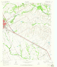
 1965 Corbet1967 Print · USGSThe western outskirts of Corsicana in the mid-1960s show a landscape of rail-line intersections and local institutions. Genealogists can trace family landmarks like Cunningham Cem, the State Orphans Home, and the Whites Chapel community.2 unique versions available
 - 1965 Map of Frost, 1967 Print
 1965 Frost1967 Print · USGSNavarro County's agricultural heartland is captured here in the mid-sixties, centered on the hub of Frost. Historians and genealogists can trace rural family roots through several local burial grounds like Blanton-Hooser Cem, Richland Cem, and Pevehouse Cem.
 - 1965 Map of Union High, 1967 Print
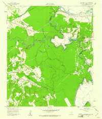
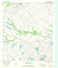
 1965 Union High1967 Print · USGSThe rural borderlands of Navarro and Limestone counties are shown in the mid-1960s, featuring a landscape undergoing major hydrological changes. Researchers can locate vanished landmarks like Union High and Shady Grove Ch, or trace the numerous soil conservation reservoirs from Dam No 31 to Dam No 19.
Showing maps 1-25 of 27
Top cities of Navarro County
- Corsicana historical maps
- Kerens historical maps
- Rice historical maps
- Blooming Grove historical maps
- Dawson historical maps
- Frost historical maps
See more
Frequently asked questions
- What are the different types of historical maps available for Navarro County?
- What is the oldest map of Navarro County?
- Where can I purchase historical maps of Navarro County for my home or office?
- Where can I download high-res historical maps of Navarro County?
- Are there historical topographic maps available for Navarro County?
- Is there historical aerial imagery available for Navarro County?
- Where are historical maps of Navarro County sourced from?