1960s Maps of Rice, Texas
Explore 4 historic maps of Rice from the 1960s. These maps offer a rare glimpse into what life looked like during the 1960s — showing old roads, neighborhoods, homes, and landmarks that have changed or disappeared over time.
Whether you're researching your family's past, planning a metal detecting trip, or studying how Rice's landscape evolved across the 1960s, these high-resolution maps are a powerful tool for exploring the history of this region.
- Focus on a specific era: All maps on this page are from the 1960s, giving you a focused view of this time period.
- See what’s changed: Compare century-old streets, trails, and buildings to today's modern landscape using overlays and satellite layers.
- Research with precision: Use these maps for genealogy, historical research, land use analysis, or educational projects.
- View, download, or print: Maps are fully viewable online in high resolution, and can be downloaded or printed for your own records.
Start exploring Rice's history through authentic maps from the 1960s. This is your window into the past.
Rice, TX maps
(4)- 1961 Map of Chatfield, 1966 Print
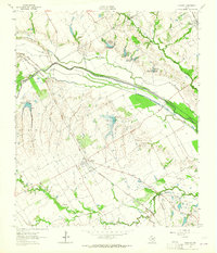
 1961 Chatfield1966 Print · USGSNavarro County's petroleum and agricultural heartland is documented here during the early sixties, showing the expansion of the Corsicana Oil Field. Genealogists and historians can trace family locations near Chatfield Cem, Roane, and the Tupelo Ch.
 - 1962 Map of Emhouse, 1965 Print
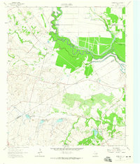
 1962 Emhouse1965 Print · USGSNorth of Corsicana in the early sixties, the borderlands of Navarro and Ellis Counties supported a landscape of prairie creeks and busy rail lines. Trace family history near Emhouse, locate the Pattison Cem, and follow the path of the Rock Island and Pacific railroad.2 unique versions available
 - 1962 Map of Ennis East, 1965 Print
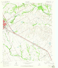 1962 Ennis East1965 Print · USGSEastern Ellis County in the early 1960s shows a landscape of rail-linked prairie towns and country schools. Genealogists can trace family footprints at Redwine Cem, Alma, and the St Johns Ch.3 unique versions available
 - 1962 Map of Rosser SW, 1965 Print
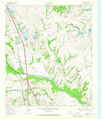
 1962 Rosser SW1965 Print · USGSNavarro County in the early 1960s was a landscape of rural family farms and emerging water management systems along the Trinity River. Local researchers can locate Rice Cem, the Hopewell Ch, and several named reservoirs along Grays Creek.
End of results
Showing maps 1-4 of 4
Top cities near Rice
- Corsicana historical maps
- Ennis historical maps
- Palmer historical maps
- Seven Points historical maps
- Blooming Grove historical maps
- Bardwell historical maps
See more
Frequently asked questions
- What are the different types of historical maps available for Rice?
- What is the oldest map of Rice?
- Where can I purchase historical maps of Rice for my home or office?
- Where can I download high-res historical maps of Rice?
- Are there historical topographic maps available for Rice?
- Is there historical aerial imagery available for Rice?
- Where are historical maps of Rice sourced from?