1960s Maps of Richland, Texas
Explore 2 historic maps of Richland from the 1960s. These maps offer a rare glimpse into what life looked like during the 1960s — showing old roads, neighborhoods, homes, and landmarks that have changed or disappeared over time.
Whether you're researching your family's past, planning a metal detecting trip, or studying how Richland's landscape evolved across the 1960s, these high-resolution maps are a powerful tool for exploring the history of this region.
- Focus on a specific era: All maps on this page are from the 1960s, giving you a focused view of this time period.
- See what’s changed: Compare century-old streets, trails, and buildings to today's modern landscape using overlays and satellite layers.
- Research with precision: Use these maps for genealogy, historical research, land use analysis, or educational projects.
- View, download, or print: Maps are fully viewable online in high resolution, and can be downloaded or printed for your own records.
Start exploring Richland's history through authentic maps from the 1960s. This is your window into the past.
Richland, TX maps
(2)- 1963 Map of Richland, 1966 Print
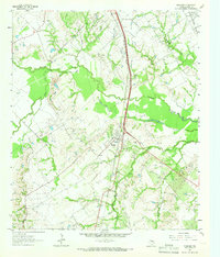 1963 Richland1966 Print · USGSThe Richland area in the early sixties is a study in Texas rail and oil history, centered on the crossing of the Southern Pacific and Fort Worth & Denver lines. Genealogists and researchers can trace local roots at Carroll Chapel Cem, Richland Sch, and the Powell Oil Field.2 unique versions available
 - 1963 Map of Wortham, 1966 Print
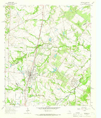 1963 Wortham1966 Print · USGSThe community of Wortham sits at the heart of the Texas oil patch in the early sixties. Genealogists and researchers can trace the Southern Pacific rail line between Currie and Gude, and locate family sites like Miller Cem or Red Cem.2 unique versions available
End of results
Showing maps 1-2 of 2
Top cities near Richland
- Corsicana historical maps
- Mexia historical maps
- Teague historical maps
- Fairfield historical maps
- Wortham historical maps
- Coolidge historical maps
See more
Frequently asked questions
- What are the different types of historical maps available for Richland?
- What is the oldest map of Richland?
- Where can I purchase historical maps of Richland for my home or office?
- Where can I download high-res historical maps of Richland?
- Are there historical topographic maps available for Richland?
- Is there historical aerial imagery available for Richland?
- Where are historical maps of Richland sourced from?